
ဖိုင်:EU Pop2008 1024.PNG

ဤနမူနာ၏ အရွယ်အစား - ၆၀၀ × ၅၉၉ ပစ်ဇယ်။ အခြား ပုံရိပ်ပြတ်သားမှု: ၂၄၀ × ၂၄၀ ပစ်ဇယ် | ၄၈၁ × ၄၈၀ ပစ်ဇယ် | ၇၆၉ × ၇၆၈ ပစ်ဇယ် | ၁၀၂၅ × ၁၀၂၄ ပစ်ဇယ် | ၁၅၃၆ × ၁၅၃၄ ပစ်ဇယ်။
မူရင်းဖိုင် (၁၅၃၆ × ၁၅၃၄ pixels, ဖိုင်အရွယ်အစား - ၂၄၉ KB, MIME အမျိုးအစား image/png)
| ဤဖိုင်သည် Wikimedia Commons မှဖြစ်ပြီး အခြားပရောဂျက်များတွင် သုံးကောင်းသုံးလိမ့်မည်။ ယင်း၏ ဖိုင်အကြောင်းစာမျက်နှာ တွင် ဖော်ပြထားချက်ကို အောက်တွင် ပြထားသည်။ Commons သည် မူပိုင်ခွင့်လွတ်လပ်သော မီဒီယာဖိုင်များ သိုလှောင်ထားရာ နေရာ ဖြစ်သည်။ သင်လည်း ပါဝင်ကူညီနိုင်ပါသည်။ |

|
This demographic map image could be re-created using vector graphics as an SVG file. This has several advantages; see Commons:Media for cleanup for more information. If an SVG form of this image is available, please upload it and afterwards replace this template with
{{vector version available|new image name}}.
It is recommended to name the SVG file “EU Pop2008 1024.svg”—then the template Vector version available (or Vva) does not need the new image name parameter. |
အကျဉ်းချုပ်
| ဖော်ပြချက် |
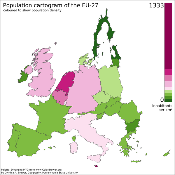
English: A preliminary population cartogram of the EU-27 made with ScapeToad 1.1 using a cut-down and reprojected public domain world shapefile (projection: Lambert Azimuthal Equal Area) and January 2008 population data from Eurostat. This version includes Dutch barrier islands. |
| ရက်စွဲ | |
| ရင်းမြစ် | ကိုယ်ပိုင်ဖန်တီးမှု |
| စာရေးသူ | Vinny Burgoo |
| အခြား ဗားရှင်းများ | Derivative works of this file: EU Pop2008 1024 new.png |
See also Geoilex's EU cartogram.
လိုင်စင်သတ်မှတ်ခြင်း
| I, the copyright holder of this work, release this work into the public domain. This applies worldwide. In some countries this may not be legally possible; if so: အကျွန်ုပ်သည် ဤဖန်တီးမှုလက်ရာကို ဥပဒေအရလိုအပ်ခြင်းမရှိသည့် မည်သည့်အခြေအနေမျိုးတွက်မဆို၊ မည်သို့သော ရည်ရွယ်ချက်အတွက်မဆို ၎င်းကို မည်သူမဆို အသုံးပြုပိုင်ခွင့်အား ပေးအပ်သည်။ |
ဖိုင်မှတ်တမ်း
ဖိုင်ကို ယင်းနေ့စွဲ အတိုင်း မြင်နိုင်ရန် နေ့စွဲ/အချိန် တစ်ခုခုပေါ်တွင် ကလစ်နှိပ်ပါ။
| နေ့စွဲ/အချိန် | နမူနာပုံငယ် | မှတ်တမ်း ဒိုင်မန်းရှင်းများ | အသုံးပြုသူ | မှတ်ချက် | |
|---|---|---|---|---|---|
| ကာလပေါ် | ၁၇:၀၄၊ ၁၁ နိုဝင်ဘာ ၂၀၁၂ | | ၁၅၃၆ × ၁၅၃၄ (၂၄၉ KB) | Veikk0.ma | Optimised with OptiPNG. |
| ၁၈:၄၂၊ ၂၇ ဇူလိုင် ၂၀၀၈ |  | ၁၅၃၆ × ၁၅၃၄ (၃၆၆ KB) | Vinny Burgoo | {{Information |Description= |Source= |Date= |Author= |Permission= |other_versions= }} | |
| ၂၃:၁၂၊ ၁၄ ဇူလိုင် ၂၀၀၈ |  | ၁၀၅၄ × ၁၀၂၄ (၂၁၀ KB) | Vinny Burgoo | {{Information |Description= |Source= |Date= |Author= |Permission= |other_versions= }} | |
| ၀၁:၄၃၊ ၁၄ ဇွန် ၂၀၀၈ |  | ၁၀၂၄ × ၁၀၂၄ (၂၃၃ KB) | Vinny Burgoo | {{Information |Description= |Source= |Date= |Author= |Permission= |other_versions= }} | |
| ၁၉:၅၅၊ ၆ ဇွန် ၂၀၀၈ |  | ၁၀၂၄ × ၇၆၈ (၆၁ KB) | Vinny Burgoo | {{Information |Description={{en|1=A preliminary population cartogram of the EU-27 made with [http://chorogram.choros.ch/scapetoad/ ScapeToad] and data and shapefiles from ... can't remember.}} |Source=Own work by uploader |Author=[[User:Vinny Burgoo|Vinny |
ဖိုင်သုံးစွဲမှု
ဤဖိုင်ကို အသုံးပြုထားသော စာမျက်နှာများမရှိပါ။
ဂလိုဘယ် ဖိုင်သုံးစွဲမှု
အောက်ပါ အခြားဝီကီများတွင် ဤဖိုင်ကို အသုံးပြုထားသည်-
- af.wikipedia.org တွင် အသုံးပြုမှု
- ar.wikipedia.org တွင် အသုံးပြုမှု
- cs.wikipedia.org တွင် အသုံးပြုမှု
- en.wikipedia.org တွင် အသုံးပြုမှု
- fi.wikipedia.org တွင် အသုံးပြုမှု
- gu.wikipedia.org တွင် အသုံးပြုမှု
- hi.wikipedia.org တွင် အသုံးပြုမှု
- it.wikipedia.org တွင် အသုံးပြုမှု
- ja.wikipedia.org တွင် အသုံးပြုမှု
- ms.wikipedia.org တွင် အသုံးပြုမှု
- pt.wikipedia.org တွင် အသုံးပြုမှု
- sv.wikipedia.org တွင် အသုံးပြုမှု
- ta.wikipedia.org တွင် အသုံးပြုမှု
- tw.wikipedia.org တွင် အသုံးပြုမှု
- uk.wikipedia.org တွင် အသုံးပြုမှု
- ur.wikipedia.org တွင် အသုံးပြုမှု