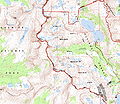
ဖိုင်:Conness-topo.jpg

အခြားဘာသာစကားများဖြင့် စာမျက်နှာအကြောင်းအရာများကို ပံ့ပိုးမထားပါ။
This is a file from the Wikimedia Commons
ဝီကီပီးဒီးယား မှ

မူရင်းဖိုင်(၅၉၈၄ × ၅၁၉၈ pixels, ဖိုင်အရွယ်အစား - ၈.၄၂ MB, MIME အမျိုးအစား image/jpeg)

အကျဉ်းချုပ်

ဖော်ပြချက်
English: Topographic map of the Mount Conness area and Hoover Wilderness Area, eastern-central Sierra Nevada, California.
ရင်းမြစ် California's archive of USGS DRG maps cropped by me
စာရေးသူ USGS
ခွင့်ပြုချက်
(ဤဖိုင်ကို ပြန်လည်အသုံးပြုခြင်း)
Public domain
This image is in the public domain in the United States because it only contains materials that originally came from the United States Geological Survey, an agency of the United States Department of the Interior. For more information, see the official USGS copyright policy.

Bahasa Indonesia  català  čeština  Deutsch  eesti  English  español  français  galego  italiano  Nederlands  português  polski  sicilianu  suomi  Tiếng Việt  Türkçe  български  македонски  русский  മലയാളം  한국어  日本語  中文  中文(简体)  中文(繁體)  العربية  فارسی  +/−

ပုံစာများ

ဤဖိုင်၏ဆိုလိုရင်းကို စာတစ်ကြောင်းရှင်းလင်းချက်ဖြင့် ထည့်သွင်းရန်

Items portrayed in this file

depicts အင်္ဂလိပ်

media type အင်္ဂလိပ်

image/jpeg

checksum အင်္ဂလိပ်

e9408282c29a8ded932ebffebc4d9e68a93b3672

determination method အင်္ဂလိပ်: SHA-1 အင်္ဂလိပ်

data size အင်္ဂလိပ်

၈၈၂၈၄၇၀ ဘိုက်

height အင်္ဂလိပ်

၅၁၉၈ pixel

width အင်္ဂလိပ်

၅၉၈၄ pixel

ဖိုင်မှတ်တမ်း

ဖိုင်ကို ယင်းနေ့စွဲ အတိုင်း မြင်နိုင်ရန် နေ့စွဲ/အချိန် တစ်ခုခုပေါ်တွင် ကလစ်နှိပ်ပါ။

နေ့စွဲ/အချိန်နမူနာပုံငယ်မှတ်တမ်း ဒိုင်မန်းရှင်းများအသုံးပြုသူမှတ်ချက်
ကာလပေါ် ၀၅:၀၁၊ ၆ ဇူလိုင် ၂၀၀၈ ၀၅:၀၁၊ ၆ ဇူလိုင် ၂၀၀၈ ရက်က မူအတွက် နမူနာပုံငယ်၅၉၈၄ × ၅၁၉၈ (၈.၄၂ MB)Eeek~commonswiki{{Information |Description={{en|1=Topographic map of the Mount Conness Area}} |Source=California's archive of USGS DRG maps cropped by me |Author=USGS |Date= |Permission= |other_versions= }} {{ImageUpload|full}}

ဤဖိုင်ကို အသုံးပြုထားသော စာမျက်နှာများမရှိပါ။

ဂလိုဘယ် ဖိုင်သုံးစွဲမှု

အောက်ပါ အခြားဝီကီများတွင် ဤဖိုင်ကို အသုံးပြုထားသည်-

မီတာဒေတာ