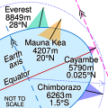
ဖိုင်:Comparison of Earth farthest points.svg

အခြားဘာသာစကားများဖြင့် စာမျက်နှာအကြောင်းအရာများကို ပံ့ပိုးမထားပါ။
This is a file from the Wikimedia Commons
ဝီကီပီးဒီးယား မှ

မူရင်းဖိုင်(SVG ဖိုင်, ၅၁၂ × ၅၁၂ pixels ကို အကြံပြုသည်, ဖိုင်အရွယ်အစား - ၃ KB)

အကျဉ်းချုပ်

ဖော်ပြချက် Highly exaggerated comparison of highest elevation (green), highest from its base (orange), farthest point from Earth's axis (pink) and farthest point from Earth's centre (blue), by CMG Lee.
ရင်းမြစ် ကိုယ်ပိုင်ဖန်တီးမှု
စာရေးသူ Cmglee
SVG genesis
InfoField
W3C grn 
SVG ၏ ကုဒ်သည် ခိုင်လုံသည်.
Unknown logo-V 
This diagram was created with unknown tool.
OOjs UI icon language-constructive 
This diagram uses translateable embedded text.

လိုင်စင်သတ်မှတ်ခြင်း

ကျွန်ုပ်၊ ဤလုပ်ဆောင်ချက်၏ မူပိုင်ခွင့်ပိုင်ရှင်အနေဖြင့် ဤနေရာမှ အောက်ပါလိုင်စင်များအောက်တွင် ထုတ်လွှင့်ပါသည်:
w:my:Creative Commons
မှတ်ယူနိုင်ခြင်း ထပ်တူမျှဝေ
ဤဖိုင်သည် Creative Commons Attribution-Share Alike 4.0 နိုင်ငံတကာ လိုင်စင်အောက်တွင် လိုင်စင်သတ်မှတ်ထားပါသည်။
သင်သည် လွတ်လပ်စွာ:
  • မျှဝေရန် – ဖန်တီးမှုကို ကူးယူရန်၊ ဖြန့်ဖြူးရန်နှင့် ထုတ်လွှင့်ရန်
  • ပြန်ရောနှောရန် – ဖန်တီးမှုကို ပြင်ဆင်ညှိနှိုင်းရန်
အောက်ပါ အခြေအနေများတွင်:
  • မှတ်ယူနိုင်ခြင်း – ပြောင်းလဲမှုများ ပြုလုပ်ခဲ့ပါက ဖန်တီးသူ သို့မဟုတ် လိုင်စင်ရှိသူမှ သတ်မှတ်သော အမျိုးအစားကို လိုက်နာရမည် (ဆိုလိုသည်မှာ သင့်အား သို့မဟုတ် သင့်ဖန်တီးမှုတွင် အသုံးပြုခြင်းအား ထောက်ခံချက်ပေးသည်ဟု မဆိုလိုပါ)။
  • ထပ်တူမျှဝေ – ဤဖန်တီးမှုအား ပြင်ဆင်ခြင်း၊ ပြောင်းလဲခြင်း သို့မဟုတ် ထပ်ဆင့် ဖန်တီးခြင်း ပြုလုပ်ပါက ရရှိလာသော ဖန်တီးမှုကို ဤဖန်တီးမှုနှင့် သို့မဟုတ် ဆင်တူသော လိုင်စင်ဖြင့်သာ ဖြန့်ချိသင့်သည်။
GNU head ဤစာတမ်းကို GNU Free Documentation License, ဗားရှင်း ၁.၂ သို့မဟုတ် Free Software Foundation မှ ဖြန့်ချီထားသော မည်သည့်ယခင်ဗားရှင်းတစ်ခုခုအောက်တွင် Invariant Sections, Front-Cover Texts နှင့် Back-Cover Texts များမပါဝင်ဘဲ ကူးယူခြင်း၊ ဖြန့်ချီခြင်း နှင့်/သို့မဟုတ် ပြင်ဆင်ပြောင်းလဲနိုင်ရန် ခွင့်ပြုသည်။ လိုင်စင်မူပွားကို GNU Free Documentation License ခေါင်းစဉ်အောက်တွင် ထည့်သွင်းထားသည်။
သင်အလိုရှိရာ လိုင်စင်ကို ရွေးချယ်နိုင်ပါသည်။

ပုံစာများ

ဤဖိုင်၏ဆိုလိုရင်းကို စာတစ်ကြောင်းရှင်းလင်းချက်ဖြင့် ထည့်သွင်းရန်

Items portrayed in this file

depicts အင်္ဂလိပ်

media type အင်္ဂလိပ်

image/svg+xml

checksum အင်္ဂလိပ်

c3f5f396a108a49be6240a0a36473b6d4c5d2441

determination method အင်္ဂလိပ်: SHA-1 အင်္ဂလိပ်

data size အင်္ဂလိပ်

၃၅၆၀ ဘိုက်

height အင်္ဂလိပ်

၅၁၂ pixel

width အင်္ဂလိပ်

၅၁၂ pixel

ဖိုင်မှတ်တမ်း

ဖိုင်ကို ယင်းနေ့စွဲ အတိုင်း မြင်နိုင်ရန် နေ့စွဲ/အချိန် တစ်ခုခုပေါ်တွင် ကလစ်နှိပ်ပါ။

နေ့စွဲ/အချိန်နမူနာပုံငယ်မှတ်တမ်း ဒိုင်မန်းရှင်းများအသုံးပြုသူမှတ်ချက်
ကာလပေါ် ၀၉:၃၀၊ ၇ မေ ၂၀၂၃ ၀၉:၃၀၊ ၇ မေ ၂၀၂၃ ရက်က မူအတွက် နမူနာပုံငယ်၅၁၂ × ၅၁၂ (၃ KB)CmgleeAdd Mauna Kea
၁၀:၂၃၊ ၃၀ ဧပြီ ၂၀၂၃ ၁၀:၂၃၊ ၃၀ ဧပြီ ၂၀၂၃ ရက်က မူအတွက် နမူနာပုံငယ်၅၁၂ × ၅၁၂ (၃ KB)CmgleeReduce font size // Editing SVG source code using c:User:Rillke/SVGedit.js
၁၃:၁၃၊ ၂၃ အောက်တိုဘာ ၂၀၂၁ ၁၃:၁၃၊ ၂၃ အောက်တိုဘာ ၂၀၂၁ ရက်က မူအတွက် နမူနာပုံငယ်၅၁၂ × ၅၁၂ (၃ KB)Cmglee{{Information |Description=Comparisons of Earth's highest elevation (green), the farthest point from Earth's axis (red) and farthest point from Earth's centre (blue) by CMG Lee. |Source={{own}} |Date= |Author= Cmglee |Permission= |other_versions= }} Category:Geodesy Category:Cayambe Category:Chimborazo

ဤဖိုင်ကို အသုံးပြုထားသော စာမျက်နှာများမရှိပါ။

ဂလိုဘယ် ဖိုင်သုံးစွဲမှု

အောက်ပါ အခြားဝီကီများတွင် ဤဖိုင်ကို အသုံးပြုထားသည်-

မီတာဒေတာ