
ဖိုင်:Commonwealth republics.svg

Size of this PNG preview of this SVG file: ၈၀၀ × ၄၀၆ ပစ်ဇယ်. အခြား ပုံရိပ်ပြတ်သားမှု: ၃၂၀ × ၁၆၂ ပစ်ဇယ် | ၆၄၀ × ၃၂၅ ပစ်ဇယ် | ၁၀၂၄ × ၅၂၀ ပစ်ဇယ် | ၁၂၈၀ × ၆၅၀ ပစ်ဇယ် | ၂၅၆၀ × ၁၃၀၀ ပစ်ဇယ် | ၂၇၅၄ × ၁၃၉၈ ပစ်ဇယ်။
မူရင်းဖိုင် (SVG ဖိုင်, ၂၇၅၄ × ၁၃၉၈ pixels ကို အကြံပြုသည်, ဖိုင်အရွယ်အစား - ၁.၀၅ MB)
| ဤဖိုင်သည် Wikimedia Commons မှဖြစ်ပြီး အခြားပရောဂျက်များတွင် သုံးကောင်းသုံးလိမ့်မည်။ ယင်း၏ ဖိုင်အကြောင်းစာမျက်နှာ တွင် ဖော်ပြထားချက်ကို အောက်တွင် ပြထားသည်။ Commons သည် မူပိုင်ခွင့်လွတ်လပ်သော မီဒီယာဖိုင်များ သိုလှောင်ထားရာ နေရာ ဖြစ်သည်။ သင်လည်း ပါဝင်ကူညီနိုင်ပါသည်။ |
အကျဉ်းချုပ်
| ဖော်ပြချက် |
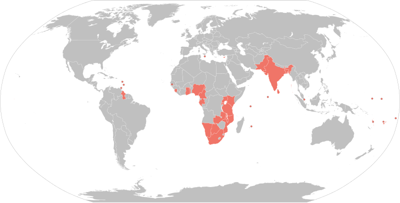
English: States within the Commonwealth of Nations that are Republics shaded in red. A Robinson projection map of the world. |
| ရက်စွဲ | |
| ရင်းမြစ် | Based on File:BlankMap-World6.svg (previous revisions based on File:World Map Blank.svg) |
| စာရေးသူ | Rcsprinter123 |
| အခြား ဗားရှင်းများ |
See also  |
လိုင်စင်သတ်မှတ်ခြင်း
ကျွန်ုပ်၊ ဤလုပ်ဆောင်ချက်၏ မူပိုင်ခွင့်ပိုင်ရှင်အနေဖြင့် ဤနေရာမှ အောက်ပါလိုင်စင်အောက်တွင် ထုတ်လွှင့်ပါသည်:
ဤဖိုင်သည် Creative Commons Attribution 3.0 Unported လိုင်စင်အောက်တွင် လိုင်စင်သတ်မှတ်ထားပါသည်။
- သင်သည် လွတ်လပ်စွာ:
- မျှဝေရန် – ဖန်တီးမှုကို ကူးယူရန်၊ ဖြန့်ဖြူးရန်နှင့် ထုတ်လွှင့်ရန်
- ပြန်ရောနှောရန် – ဖန်တီးမှုကို ပြင်ဆင်ညှိနှိုင်းရန်
- အောက်ပါ အခြေအနေများတွင်:
- မှတ်ယူနိုင်ခြင်း – ပြောင်းလဲမှုများ ပြုလုပ်ခဲ့ပါက ဖန်တီးသူ သို့မဟုတ် လိုင်စင်ရှိသူမှ သတ်မှတ်သော အမျိုးအစားကို လိုက်နာရမည် (ဆိုလိုသည်မှာ သင့်အား သို့မဟုတ် သင့်ဖန်တီးမှုတွင် အသုံးပြုခြင်းအား ထောက်ခံချက်ပေးသည်ဟု မဆိုလိုပါ)။
ဖိုင်မှတ်တမ်း
ဖိုင်ကို ယင်းနေ့စွဲ အတိုင်း မြင်နိုင်ရန် နေ့စွဲ/အချိန် တစ်ခုခုပေါ်တွင် ကလစ်နှိပ်ပါ။
| နေ့စွဲ/အချိန် | နမူနာပုံငယ် | မှတ်တမ်း ဒိုင်မန်းရှင်းများ | အသုံးပြုသူ | မှတ်ချက် | |
|---|---|---|---|---|---|
| ကာလပေါ် | ၂၂:၀၈၊ ၁၈ ဇူလိုင် ၂၀၂၂ | | ၂၇၅၄ × ၁၃၉၈ (၁.၀၅ MB) | M.Bitton | Added Gabon and Togo, per request |
| ၀၃:၀၀၊ ၂၁ ဒီဇင်ဘာ ၂၀၂၁ |  | ၂၇၅၄ × ၁၃၉၈ (၁.၀၅ MB) | Floogan | Reverted to version as of 02:51, 21 December 2021 (UTC) | |
| ၀၂:၅၃၊ ၂၁ ဒီဇင်ဘာ ၂၀၂၁ |  | ၈၆၃ × ၄၄၃ (၁.၅၉ MB) | Floogan | Reverted to version as of 22:32, 10 February 2018 (UTC) | |
| ၀၂:၅၁၊ ၂၁ ဒီဇင်ဘာ ၂၀၂၁ |  | ၂၇၅၄ × ၁၃၉၈ (၁.၀၅ MB) | Floogan | adding maldives and barbados | |
| ၂၂:၃၂၊ ၁၀ ဖေဖော်ဝါရီ ၂၀၁၈ |  | ၈၆၃ × ၄၄၃ (၁.၅၉ MB) | DrKay | remove Northern Cyprus add Gambia | |
| ၁၄:၃၃၊ ၂၅ နိုဝင်ဘာ ၂၀၁၆ |  | ၈၆၃ × ၄၄၃ (၁.၅၉ MB) | Maproom | Maldives from orange to grey, they left the Commonwealth in October 2016 | |
| ၀၄:၁၄၊ ၂၇ ဖေဖော်ဝါရီ ၂၀၁၆ |  | ၈၆၃ × ၄၄၃ (၁.၅၉ MB) | Jolly Janner | Adding Tanzania per article | |
| ၂၁:၁၆၊ ၂၉ ဇူလိုင် ၂၀၁၅ |  | ၈၆၃ × ၄၄၃ (၁.၅၅ MB) | MellonDor | Now using BlankMap-World6.svg as the template and added some missing republics. | |
| ၁၁:၅၅၊ ၁၁ ဧပြီ ၂၀၁၅ |  | ၂၇၅၃ × ၁၅၃၈ (၂.၁၇ MB) | Rcsprinter123 | User created page with UploadWizard |
ဖိုင်သုံးစွဲမှု
ဤဖိုင်ကို အသုံးပြုထားသော စာမျက်နှာများမရှိပါ။
ဂလိုဘယ် ဖိုင်သုံးစွဲမှု
အောက်ပါ အခြားဝီကီများတွင် ဤဖိုင်ကို အသုံးပြုထားသည်-
- en.wikipedia.org တွင် အသုံးပြုမှု
- fr.wikipedia.org တွင် အသုံးပြုမှု
- fr.wiktionary.org တွင် အသုံးပြုမှု
- sq.wikipedia.org တွင် အသုံးပြုမှု
- te.wikipedia.org တွင် အသုံးပြုမှု
- tr.wikipedia.org တွင် အသုံးပြုမှု