
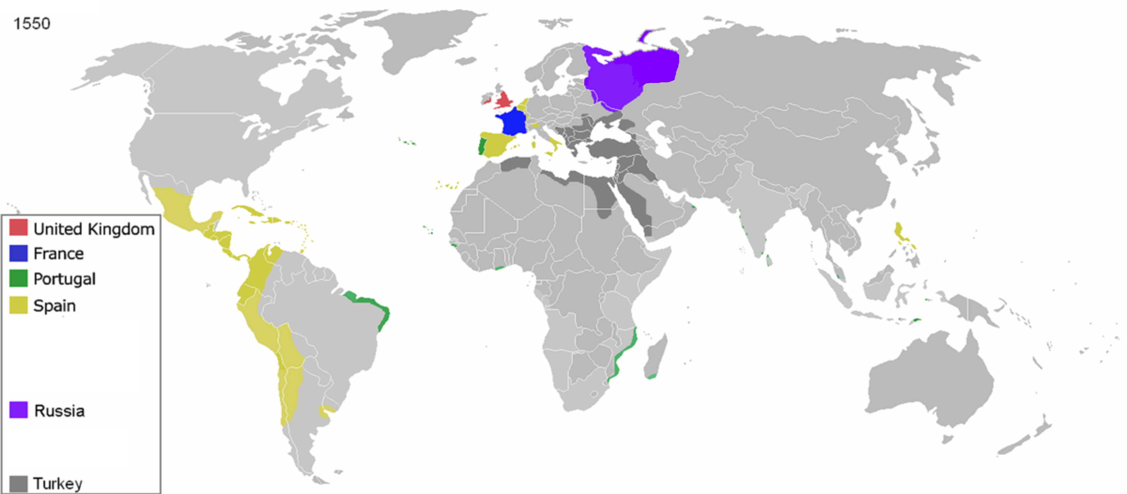
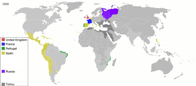
ဖိုင်:Colonisation 1550.png
မူရင်းဖိုင် (၃၆၀၀ × ၁၅၇၈ pixels, ဖိုင်အရွယ်အစား - ၁.၁၄ MB, MIME အမျိုးအစား image/png)
| ဤဖိုင်သည် Wikimedia Commons မှဖြစ်ပြီး အခြားပရောဂျက်များတွင် သုံးကောင်းသုံးလိမ့်မည်။ ယင်း၏ ဖိုင်အကြောင်းစာမျက်နှာ တွင် ဖော်ပြထားချက်ကို အောက်တွင် ပြထားသည်။ Commons သည် မူပိုင်ခွင့်လွတ်လပ်သော မီဒီယာဖိုင်များ သိုလှောင်ထားရာ နေရာ ဖြစ်သည်။ သင်လည်း ပါဝင်ကူညီနိုင်ပါသည်။ |
| ဖော်ပြချက် |
Map of major world powers by year
As the orriginal licence of the animation was Public Domain, this image which has been derived from it is too:
|
||||||||||||||||||
| ရက်စွဲ | |||||||||||||||||||
| ရင်းမြစ် | public domain animated map by ArdadN here | ||||||||||||||||||
| စာရေးသူ | ArdadN | ||||||||||||||||||
.jpg)
._LOC_2001620596.jpg)

|
This historical map image could be re-created using vector graphics as an SVG file. This has several advantages; see Commons:Media for cleanup for more information. If an SVG form of this image is available, please upload it and afterwards replace this template with
{{vector version available|new image name}}.
It is recommended to name the SVG file “Colonisation 1550.svg”—then the template Vector version available (or Vva) does not need the new image name parameter. |
ဖိုင်မှတ်တမ်း
ဖိုင်ကို ယင်းနေ့စွဲ အတိုင်း မြင်နိုင်ရန် နေ့စွဲ/အချိန် တစ်ခုခုပေါ်တွင် ကလစ်နှိပ်ပါ။
| နေ့စွဲ/အချိန် | နမူနာပုံငယ် | မှတ်တမ်း ဒိုင်မန်းရှင်းများ | အသုံးပြုသူ | မှတ်ချက် | |
|---|---|---|---|---|---|
| ကာလပေါ် | ၁၁:၃၂၊ ၂၆ ဧပြီ ၂၀၂၀ | | ၃၆၀၀ × ၁၅၇၈ (၁.၁၄ MB) | Ориенталист | Clarified the territory of Russia by 1550 |
| ၀၉:၂၅၊ ၅ ဧပြီ ၂၀၂၀ |  | ၃၆၀၀ × ၁၅၇၈ (၁.၁၄ MB) | Ориенталист | cosmetic changes | |
| ၁၄:၅၅၊ ၂၇ မတ် ၂၀၂၀ |  | ၄၂၇၅ × ၁၈၇၅ (၁.၀၅ MB) | Ориенталист | Clarified the territory of Russia. | |
| ၂၃:၂၅၊ ၃ မေ ၂၀၁၀ |  | ၁၄၂၅ × ၆၂၅ (၇၃ KB) | Kieran4 | Fixed errors. | |
| ၁၀:၄၀၊ ၂၂ မတ် ၂၀၀၇ |  | ၁၄၂၅ × ၆၂၅ (၆၅ KB) | Roke~commonswiki | {{Information |Description=Map of major world powers by year {{Maps of world history}} As the orriginal licence of the animation was Public Domain, this image which has been derived from it is too: {{PD-User|Andrei nacu}} |Source=public domain animated m |
ဖိုင်သုံးစွဲမှု
ဤဖိုင်ကို အသုံးပြုထားသော စာမျက်နှာများမရှိပါ။
ဂလိုဘယ် ဖိုင်သုံးစွဲမှု
အောက်ပါ အခြားဝီကီများတွင် ဤဖိုင်ကို အသုံးပြုထားသည်-
- af.wikipedia.org တွင် အသုံးပြုမှု
- ast.wikipedia.org တွင် အသုံးပြုမှု
- bn.wikipedia.org တွင် အသုံးပြုမှု
- bs.wikipedia.org တွင် အသုံးပြုမှု
- cs.wikipedia.org တွင် အသုံးပြုမှု
- de.wikipedia.org တွင် အသုံးပြုမှု
- en.wikipedia.org တွင် အသုံးပြုမှု
- es.wikipedia.org တွင် အသုံးပြုမှု
- fa.wikipedia.org တွင် အသုံးပြုမှု
- fr.wikipedia.org တွင် အသုံးပြုမှု
- he.wikipedia.org တွင် အသုံးပြုမှု
- kk.wikipedia.org တွင် အသုံးပြုမှု
- mg.wikipedia.org တွင် အသုံးပြုမှု
- no.wikipedia.org တွင် အသုံးပြုမှု
- pt.wikipedia.org တွင် အသုံးပြုမှု
- sk.wikipedia.org တွင် အသုံးပြုမှု