ဖိုင်:China map.png

အခြားဘာသာစကားများဖြင့် စာမျက်နှာအကြောင်းအရာများကို ပံ့ပိုးမထားပါ။
This is a file from the Wikimedia Commons
ဝီကီပီးဒီးယား မှ

မူရင်းဖိုင်(၇၀၅ × ၇၀၅ pixels, ဖိုင်အရွယ်အစား - ၁၃၅ KB, MIME အမျိုးအစား image/png)

အကျဉ်းချုပ်

This locator map image could be re-created using vector graphics as an SVG file. This has several advantages; see Commons:Media for cleanup for more information. If an SVG form of this image is available, please upload it and afterwards replace this template with {{vector version available|new image name}}.


It is recommended to name the SVG file “China map.svg”—then the template Vector version available (or Vva) does not need the new image name parameter.
ဖော်ပြချက်
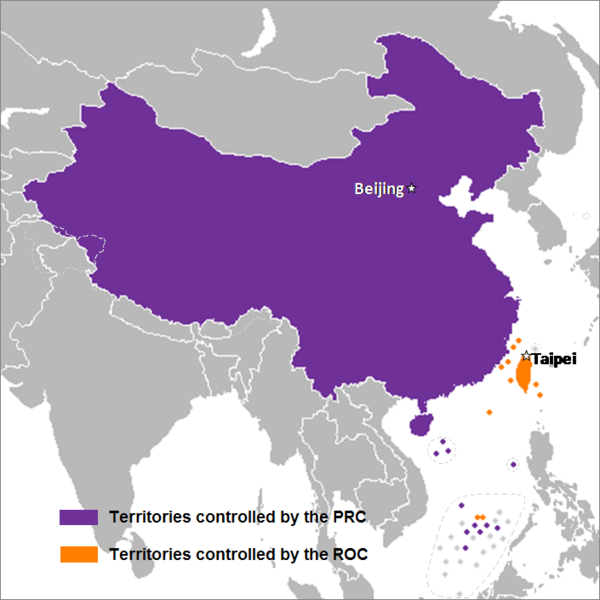
English: This is a map of the two states that officially use the name "China" in their names and depicts the actual "line of control" and not any claims that states often make. Key words: actual administration and actual maintaining of control of the territories.
中文(简体):这是一个关于两个都把“中华”用在自己的国名里的国家的地图,这个地图描绘了两国的实际“控制线”并跟两国通常声称的完全不是一回事。关键词:实际管辖和维持实际控制区域。
中文(繁體):這是一個關於兩個都把“中華”用在自己的國名裡的國家的地圖,這個地圖描繪了兩國的實際“控制線”並跟兩國通常聲稱的完全不是一回事。關鍵字:實際管轄和維持實際控制區域。
ရက်စွဲ ၂၄ စက်တင်ဘာ ၂၀၀၇ (original upload date)
ရင်းမြစ် Transferred from en.wikipedia to Commons by Sreejithk2000 using CommonsHelper.
စာရေးသူ Nat at အင်္ဂလိပ် ဝီကီပီးဒီးယား

လိုင်စင်သတ်မှတ်ခြင်း

Nat at အင်္ဂလိပ် ဝီကီပီးဒီးယား၊ ဤလုပ်ဆောင်ချက်၏ မူပိုင်ခွင့်ပိုင်ရှင်အနေဖြင့် ဤနေရာမှ အောက်ပါလိုင်စင်များအောက်တွင် ထုတ်လွှင့်ပါသည်:
GNU head ဤစာတမ်းကို GNU Free Documentation License, ဗားရှင်း ၁.၂ သို့မဟုတ် Free Software Foundation မှ ဖြန့်ချီထားသော မည်သည့်ယခင်ဗားရှင်းတစ်ခုခုအောက်တွင် Invariant Sections, Front-Cover Texts နှင့် Back-Cover Texts များမပါဝင်ဘဲ ကူးယူခြင်း၊ ဖြန့်ချီခြင်း နှင့်/သို့မဟုတ် ပြင်ဆင်ပြောင်းလဲနိုင်ရန် ခွင့်ပြုသည်။ လိုင်စင်မူပွားကို GNU Free Documentation License ခေါင်းစဉ်အောက်တွင် ထည့်သွင်းထားသည်။
w:my:Creative Commons
မှတ်ယူနိုင်ခြင်း
ဤဖိုင်သည် Creative Commons Attribution 3.0 Unported လိုင်စင်အောက်တွင် လိုင်စင်သတ်မှတ်ထားပါသည်။
မှတ်ယူနိုင်ခြင်း: Nat at အင်္ဂလိပ် ဝီကီပီးဒီးယား
သင်သည် လွတ်လပ်စွာ:
  • မျှဝေရန် – ဖန်တီးမှုကို ကူးယူရန်၊ ဖြန့်ဖြူးရန်နှင့် ထုတ်လွှင့်ရန်
  • ပြန်ရောနှောရန် – ဖန်တီးမှုကို ပြင်ဆင်ညှိနှိုင်းရန်
အောက်ပါ အခြေအနေများတွင်:
  • မှတ်ယူနိုင်ခြင်း – ပြောင်းလဲမှုများ ပြုလုပ်ခဲ့ပါက ဖန်တီးသူ သို့မဟုတ် လိုင်စင်ရှိသူမှ သတ်မှတ်သော အမျိုးအစားကို လိုက်နာရမည် (ဆိုလိုသည်မှာ သင့်အား သို့မဟုတ် သင့်ဖန်တီးမှုတွင် အသုံးပြုခြင်းအား ထောက်ခံချက်ပေးသည်ဟု မဆိုလိုပါ)။
သင်အလိုရှိရာ လိုင်စင်ကို ရွေးချယ်နိုင်ပါသည်။

မူရင်းတင်ထားသောမှတ်တမ်း

ဖော်ပြချက် မူရင်းစာမျက်နှာမှာ here ဖြစ်သည်။ အောက်ပါအသုံးပြုသူ အမည်များအားလုံးသည် en.wikipedia ကို ရည်ညွှန်းသည်။
  • 2008-05-29 22:44 Shibo77 705×705× (136871 bytes)
  • 2008-05-29 21:59 Shibo77 705×705× (135686 bytes)
  • 2008-05-29 21:53 Shibo77 705×705× (132630 bytes) Reverted to version as of 00:46, 16 May 2008
  • 2008-05-29 08:51 Sontung007 556×537× (31782 bytes) Reverted to the neutral version to avoid disputes and ambiguity
  • 2008-05-16 00:46 Taktser 705×705× (132630 bytes)
  • 2008-05-16 00:44 Taktser 705×705× (132710 bytes)
  • 2008-05-03 20:22 T-1000 705×705× (115888 bytes) Reverted to version as of 22:31, 4 April 2008
  • 2008-04-08 17:10 Heavyrain2408 705×705× (129360 bytes) Chinese people use tricky word "administration" to mislead readers to believe these islands belonging to them. Please stop these kinds of actions.
  • 2008-04-04 22:31 Taktser 705×705× (115888 bytes) Reverted to version as of 20:02, 27 March 2008 (administration is clearly stated, not the question of sovereignty over these territories, Arunachal Pradesh is excluded; Aksai Chin, the Spratly islands and some of the Paracel islands are included)
  • 2008-03-30 05:36 Heavyrain2408 705×705× (129360 bytes) Constroversary parts should not be included. This could result readers think that these parts belong to China.
  • 2008-03-27 20:02 Taktser 705×705× (115888 bytes) Reverted to version as of 20:31, 10 March 2008 It's clearly stated as administration not sovereignty
  • 2008-03-21 21:11 Sontung007 705×705× (129360 bytes) the previous map wrongly included unresolved disputed islands
  • 2008-03-10 20:31 Taktser 705×705× (115888 bytes) Reverted to version as of 16:33, 16 November 2007
  • 2008-01-24 15:26 Sinoevils 705×705× (129360 bytes) This is the real China Map
  • 2008-01-24 15:24 Sinoevils 705×705× (129360 bytes) This is the real China Map
  • 2007-11-16 16:33 Nat 705×705× (115888 bytes)
  • 2007-11-06 18:53 Nat 556×537× (30702 bytes)
  • 2007-11-05 22:48 Nat 556×537× (33377 bytes)
  • 2007-10-28 07:25 Jjhcap99 556×537× (31782 bytes) Added country names.
  • 2007-10-19 22:35 Jerrch 556×537× (30043 bytes) Capitalized the capitals
  • 2007-10-16 22:23 Nat 556×537× (30403 bytes) Reverted to version as of 19:37, 9 October 2007
  • 2007-10-16 20:34 Jerrch 556×537× (30411 bytes) Reverted to version as of 19:56, 29 September 2007
  • 2007-10-15 13:05 Jjhcap99 556×537× (33989 bytes)
  • 2007-10-09 19:37 Nat 556×537× (30403 bytes) This is the work of {{user|Nat}}
  • 2007-10-09 19:32 Nat 556×537× (32238 bytes) This is the work of {{User7|Nat}}.
  • 2007-09-29 19:56 Jerrch 556×537× (30411 bytes) changed color a little bit to make it just a little more neutral.
  • 2007-09-24 23:16 Nat 556×537× (30343 bytes)
  • 2007-09-24 01:44 Nat 1127×1069× (958918 bytes)
Annotations
InfoField
This image is annotated: View the annotations at Commons

ပုံစာများ

ဤဖိုင်၏ဆိုလိုရင်းကို စာတစ်ကြောင်းရှင်းလင်းချက်ဖြင့် ထည့်သွင်းရန်

Items portrayed in this file

depicts အင်္ဂလိပ်

၂၄ စက်တင်ဘာ 2007

media type အင်္ဂလိပ်

image/png

checksum အင်္ဂလိပ်

a3914e0e367e3234152db8229f8c9413a6fc7c3e

determination method အင်္ဂလိပ်: SHA-1 အင်္ဂလိပ်

data size အင်္ဂလိပ်

၁၃၈၅၇၈ ဘိုက်

height အင်္ဂလိပ်

၇၀၅ pixel

width အင်္ဂလိပ်

၇၀၅ pixel

ဖိုင်မှတ်တမ်း

ဖိုင်ကို ယင်းနေ့စွဲ အတိုင်း မြင်နိုင်ရန် နေ့စွဲ/အချိန် တစ်ခုခုပေါ်တွင် ကလစ်နှိပ်ပါ။

နေ့စွဲ/အချိန်နမူနာပုံငယ်မှတ်တမ်း ဒိုင်မန်းရှင်းများအသုံးပြုသူမှတ်ချက်
ကာလပေါ် ၀၆:၁၄၊ ၁၅ ဒီဇင်ဘာ ၂၀၁၄ ၀၆:၁၄၊ ၁၅ ဒီဇင်ဘာ ၂၀၁၄ ရက်က မူအတွက် နမူနာပုံငယ်၇၀၅ × ၇၀၅ (၁၃၅ KB)Shibo77..
၁၀:၂၆၊ ၂ ဇွန် ၂၀၁၀ ၁၀:၂၆၊ ၂ ဇွန် ၂၀၁၀ ရက်က မူအတွက် နမူနာပုံငယ်၇၀၅ × ၇၀၅ (၁၃၄ KB)File Upload Bot (Magnus Manske) {{BotMoveToCommons|en.wikipedia|year={{subst:CURRENTYEAR}}|month={{subst:CURRENTMONTHNAME}}|day={{subst:CURRENTDAY}}}} {{Information |Description={{en|This is a map of the two states that officially use the name "China" in their names and depicts the act

အောက်ပါ စာမျက်နှာ သည် ဤဖိုင်ကို အသုံးပြုထားသည်:

ဂလိုဘယ် ဖိုင်သုံးစွဲမှု

အောက်ပါ အခြားဝီကီများတွင် ဤဖိုင်ကို အသုံးပြုထားသည်-

ဤဖိုင်ကို အခြားနေရာများတွင် အသုံးပြုထားမှုများအား ကြည့်ရှုရန်။

မီတာဒေတာ