
ဖိုင်:China, 742.svg

Size of this PNG preview of this SVG file: ၇၀၅ × ၅၉၉ ပစ်ဇယ်. အခြား ပုံရိပ်ပြတ်သားမှု: ၂၈၂ × ၂၄၀ ပစ်ဇယ် | ၅၆၅ × ၄၈၀ ပစ်ဇယ် | ၉၀၄ × ၇၆၈ ပစ်ဇယ် | ၁၂၀၅ × ၁၀၂၄ ပစ်ဇယ် | ၂၄၀၉ × ၂၀၄၈ ပစ်ဇယ် | ၁၀၀၀ × ၈၅၀ ပစ်ဇယ်။
မူရင်းဖိုင် (SVG ဖိုင်, ၁၀၀၀ × ၈၅၀ pixels ကို အကြံပြုသည်, ဖိုင်အရွယ်အစား - ၁၆၈ KB)
| ဤဖိုင်သည် Wikimedia Commons မှဖြစ်ပြီး အခြားပရောဂျက်များတွင် သုံးကောင်းသုံးလိမ့်မည်။ ယင်း၏ ဖိုင်အကြောင်းစာမျက်နှာ တွင် ဖော်ပြထားချက်ကို အောက်တွင် ပြထားသည်။ Commons သည် မူပိုင်ခွင့်လွတ်လပ်သော မီဒီယာဖိုင်များ သိုလှောင်ထားရာ နေရာ ဖြစ်သည်။ သင်လည်း ပါဝင်ကူညီနိုင်ပါသည်။ |
အကျဉ်းချုပ်
| ဖော်ပြချက် |
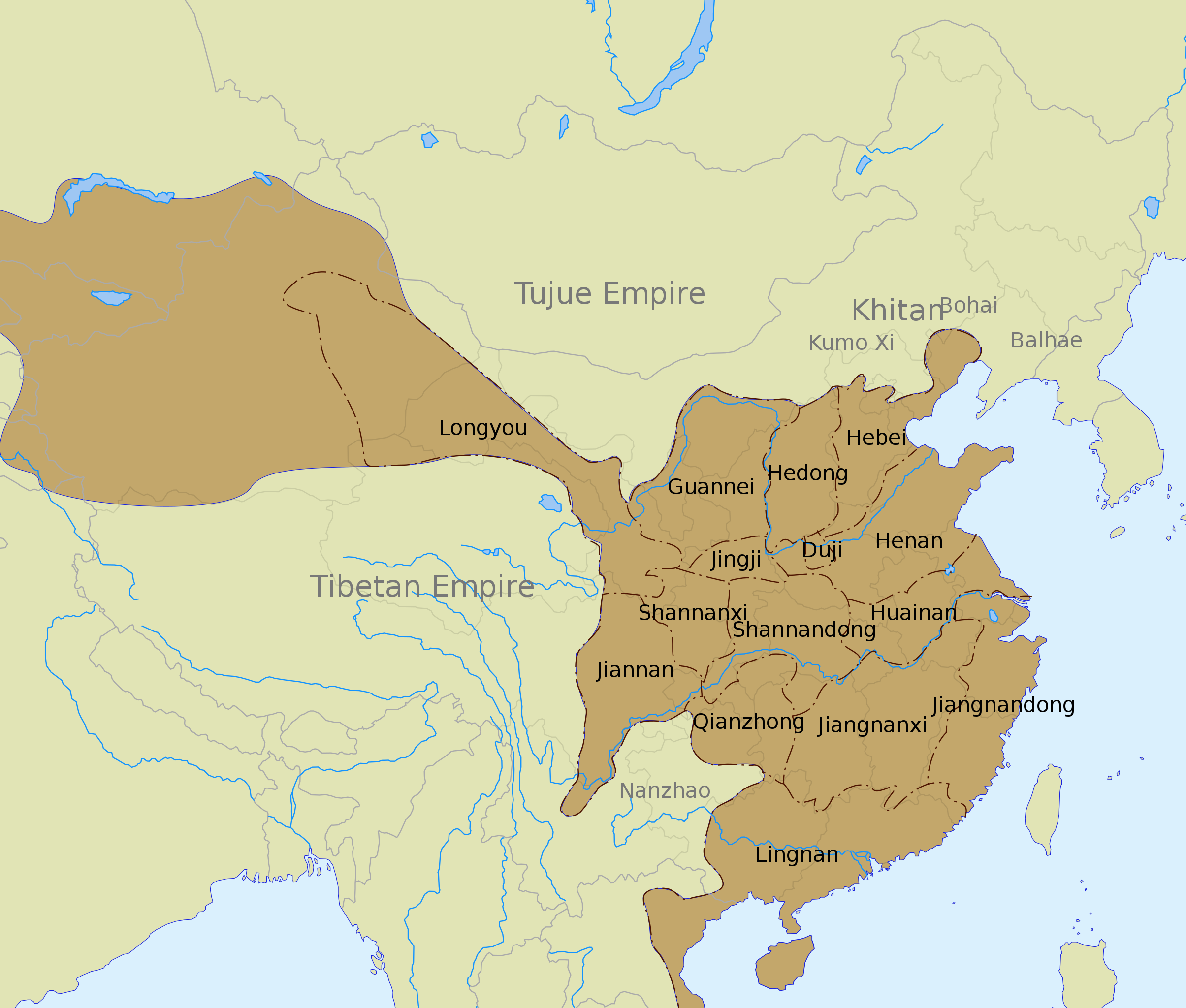
English: The Tang dynasty territory and inspection circuits (道 dào) in 742, according to the Cambridge History of China. |
| ရက်စွဲ | |
| ရင်းမြစ် |
See also:
|
| စာရေးသူ | Yug |
| အခြား ဗားရှင်းများ |
Derivative works of this file: |
| SVG genesis |
လိုင်စင်သတ်မှတ်ခြင်း
ကျွန်ုပ်၊ ဤလုပ်ဆောင်ချက်၏ မူပိုင်ခွင့်ပိုင်ရှင်အနေဖြင့် ဤနေရာမှ အောက်ပါလိုင်စင်အောက်တွင် ထုတ်လွှင့်ပါသည်:
ဤဖိုင်ကို Creative Commons Attribution-Share Alike 3.0 Unported လိုင်စင်ဖြင့် သတ်မှတ်ထားသည်။
- သင်သည် လွတ်လပ်စွာ:
- မျှဝေရန် – ဖန်တီးမှုကို ကူးယူရန်၊ ဖြန့်ဖြူးရန်နှင့် ထုတ်လွှင့်ရန်
- ပြန်ရောနှောရန် – ဖန်တီးမှုကို ပြင်ဆင်ညှိနှိုင်းရန်
- အောက်ပါ အခြေအနေများတွင်:
- မှတ်ယူနိုင်ခြင်း – ပြောင်းလဲမှုများ ပြုလုပ်ခဲ့ပါက ဖန်တီးသူ သို့မဟုတ် လိုင်စင်ရှိသူမှ သတ်မှတ်သော အမျိုးအစားကို လိုက်နာရမည် (ဆိုလိုသည်မှာ သင့်အား သို့မဟုတ် သင့်ဖန်တီးမှုတွင် အသုံးပြုခြင်းအား ထောက်ခံချက်ပေးသည်ဟု မဆိုလိုပါ)။
- ထပ်တူမျှဝေ – ဤဖန်တီးမှုအား ပြင်ဆင်ခြင်း၊ ပြောင်းလဲခြင်း သို့မဟုတ် ထပ်ဆင့် ဖန်တီးခြင်း ပြုလုပ်ပါက ရရှိလာသော ဖန်တီးမှုကို ဤဖန်တီးမှုနှင့် သို့မဟုတ် ဆင်တူသော လိုင်စင်ဖြင့်သာ ဖြန့်ချိသင့်သည်။
ဖိုင်မှတ်တမ်း
ဖိုင်ကို ယင်းနေ့စွဲ အတိုင်း မြင်နိုင်ရန် နေ့စွဲ/အချိန် တစ်ခုခုပေါ်တွင် ကလစ်နှိပ်ပါ။
| နေ့စွဲ/အချိန် | နမူနာပုံငယ် | မှတ်တမ်း ဒိုင်မန်းရှင်းများ | အသုံးပြုသူ | မှတ်ချက် | |
|---|---|---|---|---|---|
| ကာလပေါ် | ၀၁:၄၅၊ ၁၂ မတ် ၂၀၂၀ | | ၁၀၀၀ × ၈၅၀ (၁၆၈ KB) | Jonteemil | Fake SVG Reverted to version as of 17:36, 16 December 2012 (UTC) |
| ၀၆:၁၀၊ ၁၄ ဇန်နဝါရီ ၂၀၁၉ |  | ၁၀၀၀ × ၈၅၀ (၂၇၈ KB) | 复旦大学张超 | Bohai and Balhae are the same | |
| ၁၇:၃၆၊ ၁၆ ဒီဇင်ဘာ ၂၀၁၂ |  | ၁၀၀၀ × ၈၅၀ (၁၆၈ KB) | Kanguole | Revise western extent of civil administration per Cambridge History | |
| ၀၄:၄၀၊ ၃၀ မေ ၂၀၀၈ |  | ၁၀၀၀ × ၈၅၀ (၂၂၁ KB) | Yug | Correction for the eastern area, according to a newly find sources. | |
| ၀၅:၀၄၊ ၂၉ မေ ၂၀၀၈ |  | ၁၀၀၀ × ၈၅၀ (၂၂၁ KB) | Yug | ||
| ၁၈:၅၆၊ ၂၈ မေ ၂၀၀၈ |  | ၁၀၀၀ × ၈၅၀ (၂၁၈ KB) | Yug | {{Information |Description={{en|1=The Tang dynasty territory and provinces in 742, according to the Cambridge History of China.<br />NB: The Western area was not depict by my source, accordingly, this area (Longyou province, 隴右) is show by a blur area |
ဖိုင်သုံးစွဲမှု
ဤဖိုင်ကို အသုံးပြုထားသော စာမျက်နှာများမရှိပါ။
ဂလိုဘယ် ဖိုင်သုံးစွဲမှု
အောက်ပါ အခြားဝီကီများတွင် ဤဖိုင်ကို အသုံးပြုထားသည်-
- azb.wikipedia.org တွင် အသုံးပြုမှု
- bo.wikipedia.org တွင် အသုံးပြုမှု
- ca.wikipedia.org တွင် အသုံးပြုမှု
- ce.wikipedia.org တွင် အသုံးပြုမှု
- de.wikipedia.org တွင် အသုံးပြုမှု
- en.wikipedia.org တွင် အသုံးပြုမှု
- History of China
- Tang dynasty
- Han Chinese
- History of the Khitans
- Circuit (administrative division)
- An Lushan
- Emperor Xuanzong of Tang
- Wikipedia:Graphics Lab/Images to improve/Archive/Jul 2008
- User talk:PericlesofAthens/Archive 5
- Jiangnanxi Circuit
- Jiangnan Circuit
- Administrative divisions of the Tang dynasty
- Administration of territory in dynastic China
- Talk:Tang dynasty/Archive 4
- User:Falcaorib/Medieval Empires (650-800 AD)
- fa.wikipedia.org တွင် အသုံးပြုမှု
- fr.wikipedia.org တွင် အသုံးပြုမှု
- hak.wikipedia.org တွင် အသုံးပြုမှု
- id.wikipedia.org တွင် အသုံးပြုမှု
- lt.wikipedia.org တွင် အသုံးပြုမှု
- nl.wikipedia.org တွင် အသုံးပြုမှု
- no.wikipedia.org တွင် အသုံးပြုမှု
- ru.wikipedia.org တွင် အသုံးပြုမှု
- tr.wikipedia.org တွင် အသုံးပြုမှု
- uk.wikipedia.org တွင် အသုံးပြုမှု
- uz.wikipedia.org တွင် အသုံးပြုမှု
- vi.wikipedia.org တွင် အသုံးပြုမှု
- www.wikidata.org တွင် အသုံးပြုမှု
ဤဖိုင်ကို အခြားနေရာများတွင် အသုံးပြုထားမှုများအား ကြည့်ရှုရန်။