
ဖိုင်:Cartlinearlarge.png
သည်ထက်ကြီးသော resolution မရှိပါ.
Cartlinearlarge.png (၇၀၁ × ၄၄၈ pixels, ဖိုင်အရွယ်အစား - ၁၈၅ KB, MIME အမျိုးအစား image/png)
| ဤဖိုင်သည် Wikimedia Commons မှဖြစ်ပြီး အခြားပရောဂျက်များတွင် သုံးကောင်းသုံးလိမ့်မည်။ ယင်း၏ ဖိုင်အကြောင်းစာမျက်နှာ တွင် ဖော်ပြထားချက်ကို အောက်တွင် ပြထားသည်။ Commons သည် မူပိုင်ခွင့်လွတ်လပ်သော မီဒီယာဖိုင်များ သိုလှောင်ထားရာ နေရာ ဖြစ်သည်။ သင်လည်း ပါဝင်ကူညီနိုင်ပါသည်။ |
အကျဉ်းချုပ်
| ဖော်ပြချက် |
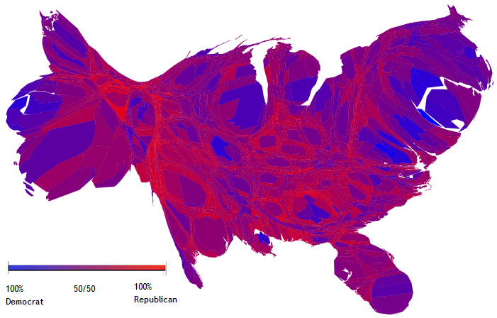
English: A cartogram depicting popular votes in the 2004 US Presidential election, in which the sizes of counties have been rescaled according to their population. |
| ရက်စွဲ | ၉ နိုဝင်ဘာ ၂၀၀၄ (original upload date) |
| ရင်းမြစ် | http://www-personal.umich.edu/~mejn/election/ |
| စာရေးသူ | Created by Michael Gastner, Cosma Shalizi, and Mark Newman of the University of Michigan. |
| အခြား ဗားရှင်းများ | File:Countycartlinear1280x1024.png |
လိုင်စင်သတ်မှတ်ခြင်း
ဤဖိုင်သည် Creative Commons Attribution 2.0 Generic လိုင်စင်အောက်တွင် လိုင်စင်သတ်မှတ်ထားပါသည်။
မှတ်ယူနိုင်ခြင်း: M. E. J. Newman
- သင်သည် လွတ်လပ်စွာ:
- မျှဝေရန် – ဖန်တီးမှုကို ကူးယူရန်၊ ဖြန့်ဖြူးရန်နှင့် ထုတ်လွှင့်ရန်
- ပြန်ရောနှောရန် – ဖန်တီးမှုကို ပြင်ဆင်ညှိနှိုင်းရန်
- အောက်ပါ အခြေအနေများတွင်:
- မှတ်ယူနိုင်ခြင်း – ပြောင်းလဲမှုများ ပြုလုပ်ခဲ့ပါက ဖန်တီးသူ သို့မဟုတ် လိုင်စင်ရှိသူမှ သတ်မှတ်သော အမျိုးအစားကို လိုက်နာရမည် (ဆိုလိုသည်မှာ သင့်အား သို့မဟုတ် သင့်ဖန်တီးမှုတွင် အသုံးပြုခြင်းအား ထောက်ခံချက်ပေးသည်ဟု မဆိုလိုပါ)။
This file, which was originally posted to
http://www-personal.umich.edu/~mejn/election/2008/, was reviewed on 29 January 2011 by reviewer Kelly, who confirmed that it was available there under the stated license on that date.
|
မူရင်းတင်ထားသောမှတ်တမ်း
ဖော်ပြချက် မူရင်းစာမျက်နှာမှာ here ဖြစ်သည်။ အောက်ပါအသုံးပြုသူ အမည်များအားလုံးသည် en.wikipedia ကို ရည်ညွှန်းသည်။
- 2005-10-19 03:55 Kyorosuke 701×448× (189341 bytes) Reverted to earlier revision
- 2005-10-19 03:54 Kyorosuke 701×448× (186897 bytes) Reverted to earlier revision
- 2005-08-09 20:07 JDoorjam 701×448× (189341 bytes) Reverted to earlier revision
- 2004-11-11 23:47 Ed g2s 701×448× (186897 bytes) cleanup key
- 2004-11-09 13:50 Jacoplane 701×448× (189341 bytes) Reverted to earlier revision
- 2004-11-09 13:50 Jacoplane 701×448× (185095 bytes) Reverted to earlier revision
- 2004-11-09 13:49 Jacoplane 701×448× (189341 bytes) add color description
- 2004-11-09 12:05 Jacoplane 701×448× (185095 bytes) a cartogram, a map in which the sizes of states have been rescaled according to their population.
ဖိုင်မှတ်တမ်း
ဖိုင်ကို ယင်းနေ့စွဲ အတိုင်း မြင်နိုင်ရန် နေ့စွဲ/အချိန် တစ်ခုခုပေါ်တွင် ကလစ်နှိပ်ပါ။
| နေ့စွဲ/အချိန် | နမူနာပုံငယ် | မှတ်တမ်း ဒိုင်မန်းရှင်းများ | အသုံးပြုသူ | မှတ်ချက် | |
|---|---|---|---|---|---|
| ကာလပေါ် | ၀၇:၅၄၊ ၂ ဇွန် ၂၀၁၀ | | ၇၀၁ × ၄၄၈ (၁၈၅ KB) | File Upload Bot (Magnus Manske) | {{BotMoveToCommons|en.wikipedia|year={{subst:CURRENTYEAR}}|month={{subst:CURRENTMONTHNAME}}|day={{subst:CURRENTDAY}}}} {{Information |Description={{en|A en:cartogram depicting popular votes in the en:2004 US Presidential election, in which th |
ဖိုင်သုံးစွဲမှု
ဤဖိုင်ကို အသုံးပြုထားသော စာမျက်နှာများမရှိပါ။
ဂလိုဘယ် ဖိုင်သုံးစွဲမှု
အောက်ပါ အခြားဝီကီများတွင် ဤဖိုင်ကို အသုံးပြုထားသည်-
- ar.wikipedia.org တွင် အသုံးပြုမှု
- en.wikipedia.org တွင် အသုံးပြုမှု
- hi.wikipedia.org တွင် အသုံးပြုမှု
- ja.wikipedia.org တွင် အသုံးပြုမှု
- uk.wikipedia.org တွင် အသုံးပြုမှု
- zh.wikipedia.org တွင် အသုံးပြုမှု