
ဖိုင်:Calgary street map.png
ဤနမူနာ၏ အရွယ်အစား - ၄၈၃ × ၆၀၀ ပစ်ဇယ်။ အခြား ပုံရိပ်ပြတ်သားမှု: ၁၉၃ × ၂၄၀ ပစ်ဇယ် | ၃၈၆ × ၄၈၀ ပစ်ဇယ် | ၉၆၀ × ၁၁၉၂ ပစ်ဇယ်။
မူရင်းဖိုင် (၉၆၀ × ၁၁၉၂ pixels, ဖိုင်အရွယ်အစား - ၈၀၂ KB, MIME အမျိုးအစား image/png)
| ဤဖိုင်သည် Wikimedia Commons မှဖြစ်ပြီး အခြားပရောဂျက်များတွင် သုံးကောင်းသုံးလိမ့်မည်။ ယင်း၏ ဖိုင်အကြောင်းစာမျက်နှာ တွင် ဖော်ပြထားချက်ကို အောက်တွင် ပြထားသည်။ Commons သည် မူပိုင်ခွင့်လွတ်လပ်သော မီဒီယာဖိုင်များ သိုလှောင်ထားရာ နေရာ ဖြစ်သည်။ သင်လည်း ပါဝင်ကူညီနိုင်ပါသည်။ |
အကျဉ်းချုပ်
| ဖော်ပြချက် |
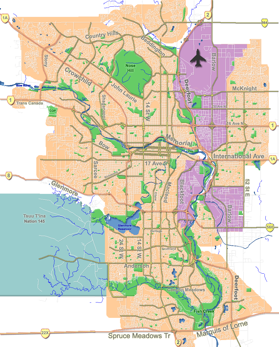
English: Outline map of Calgary. |
| ရက်စွဲ | |
| ရင်းမြစ် | GIS data |
| စာရေးသူ | Qyd |
| အခြား ဗားရှင်းများ |
Derivative works of this file: |
| Camera location | | View this and other nearby images on: OpenStreetMap |
|---|
လိုင်စင်သတ်မှတ်ခြင်း
| I, the copyright holder of this work, release this work into the public domain. This applies worldwide. In some countries this may not be legally possible; if so: အကျွန်ုပ်သည် ဤဖန်တီးမှုလက်ရာကို ဥပဒေအရလိုအပ်ခြင်းမရှိသည့် မည်သည့်အခြေအနေမျိုးတွက်မဆို၊ မည်သို့သော ရည်ရွယ်ချက်အတွက်မဆို ၎င်းကို မည်သူမဆို အသုံးပြုပိုင်ခွင့်အား ပေးအပ်သည်။ |
ဖိုင်မှတ်တမ်း
ဖိုင်ကို ယင်းနေ့စွဲ အတိုင်း မြင်နိုင်ရန် နေ့စွဲ/အချိန် တစ်ခုခုပေါ်တွင် ကလစ်နှိပ်ပါ။
| နေ့စွဲ/အချိန် | နမူနာပုံငယ် | မှတ်တမ်း ဒိုင်မန်းရှင်းများ | အသုံးပြုသူ | မှတ်ချက် | |
|---|---|---|---|---|---|
| ကာလပေါ် | ၁၈:၃၁၊ ၇ အောက်တိုဘာ ၂၀၀၇ | | ၉၆၀ × ၁၁၉၂ (၈၀၂ KB) | Qyd | fix highway name |
| ၁၉:၄၄၊ ၁၈ ဧပြီ ၂၀၀၇ |  | ၉၆၀ × ၁၁၉၂ (၇၉၁ KB) | Qyd | spelling | |
| ၁၇:၂၈၊ ၁၈ စက်တင်ဘာ ၂၀၀၆ |  | ၉၆၀ × ၁၁၉၂ (၇၉၂ KB) | Qyd | outline industrial areas | |
| ၁၇:၂၀၊ ၁၆ ဩဂုတ် ၂၀၀၆ |  | ၉၆၀ × ၁၁၉၂ (၈၀၂ KB) | Qyd | added airport symbol and highway shields | |
| ၁၅:၂၁၊ ၁၄ ဩဂုတ် ၂၀၀၆ |  | ၉၆၀ × ၁၁၉၂ (၇၉၇ KB) | Qyd | fixed interchanges | |
| ၀၄:၄၆၊ ၁၄ ဩဂုတ် ၂၀၀၆ |  | ၉၆၀ × ၁၁၉၂ (၇၀၀ KB) | Qyd | added city parks | |
| ၀၄:၁၉၊ ၁၄ ဩဂုတ် ၂၀၀၆ |  | ၉၆၀ × ၁၁၉၂ (၆၄၅ KB) | Qyd | highways names added | |
| ၀၀:၁၇၊ ၁၄ ဩဂုတ် ၂၀၀၆ |  | ၉၆၀ × ၁၁၉၂ (၄၉၁ KB) | Qyd | {{Information |Description= Outline map of Calgary |Source=GIS data |Date=Aug 2006 |Author=Qyd |Permission=All |other_versions=Image:CalgaryAB-map.png }} Category:Calgary Category:Maps of cities in Canada |
ဖိုင်သုံးစွဲမှု
အောက်ပါ 2 စာမျက်နှာများ သည် ဤဖိုင်ကို အသုံးပြုထားသည်:
ဂလိုဘယ် ဖိုင်သုံးစွဲမှု
အောက်ပါ အခြားဝီကီများတွင် ဤဖိုင်ကို အသုံးပြုထားသည်-
- ar.wikipedia.org တွင် အသုံးပြုမှု
- ast.wikipedia.org တွင် အသုံးပြုမှု
- bh.wikipedia.org တွင် အသုံးပြုမှု
- bn.wikipedia.org တွင် အသုံးပြုမှု
- cy.wikipedia.org တွင် အသုံးပြုမှု
- da.wikipedia.org တွင် အသုံးပြုမှု
- en.wikipedia.org တွင် အသုံးပြုမှု
- McMahon Stadium
- Glenmore Reservoir
- Alberta University of the Arts
- Fish Creek Provincial Park
- Heritage Park Historical Village
- Beltline, Calgary
- Nose Hill Park
- Bowness, Calgary
- Kensington, Calgary
- Chinatown, Calgary
- Tsuu T'ina 145
- Inglewood, Calgary
- McKenzie Lake, Calgary
- Eau Claire, Calgary
- Downtown Calgary
- Foothills Medical Centre
- McKenzie Towne, Calgary
- MNP Community & Sport Centre
- List of neighbourhoods in Calgary
- Lakeview, Calgary
- Chinook Centre
- Parkdale, Calgary
- Mission, Calgary
- Marda Loop, Calgary
- Bankview, Calgary
- Mount Royal, Calgary
- Springbank Hill, Calgary
- List of airports in the Calgary area
- Telus Spark Science Centre
- Edgemont, Calgary
- Pineridge, Calgary
- Edworthy Park
- Lake Bonavista, Calgary
- Confederation Park, Calgary
- University Heights, Calgary
- The Military Museums
- Transportation in Calgary
- User:Qyd/Maps
- Market Mall
ဤဖိုင်ကို အခြားနေရာများတွင် အသုံးပြုထားမှုများအား ကြည့်ရှုရန်။