
ဖိုင်:CIAIranKarteOelGas.jpg

ဤနမူနာ၏ အရွယ်အစား - ၅၈၄ × ၅၉၉ ပစ်ဇယ်။ အခြား ပုံရိပ်ပြတ်သားမှု: ၂၃၄ × ၂၄၀ ပစ်ဇယ် | ၄၆၈ × ၄၈၀ ပစ်ဇယ် | ၆၈၇ × ၇၀၅ ပစ်ဇယ်။
မူရင်းဖိုင် (၆၈၇ × ၇၀၅ pixels, ဖိုင်အရွယ်အစား - ၅၁ KB, MIME အမျိုးအစား image/jpeg)
| ဤဖိုင်သည် Wikimedia Commons မှဖြစ်ပြီး အခြားပရောဂျက်များတွင် သုံးကောင်းသုံးလိမ့်မည်။ ယင်း၏ ဖိုင်အကြောင်းစာမျက်နှာ တွင် ဖော်ပြထားချက်ကို အောက်တွင် ပြထားသည်။ Commons သည် မူပိုင်ခွင့်လွတ်လပ်သော မီဒီယာဖိုင်များ သိုလှောင်ထားရာ နေရာ ဖြစ်သည်။ သင်လည်း ပါဝင်ကူညီနိုင်ပါသည်။ |
အကျဉ်းချုပ်

|
This file has been superseded by Iran key Petroleum Sector facilities 2004.svg. It is recommended to use the other file. Please note that deleting superseded images requires consent.
|

|
| ဖော်ပြချက် |
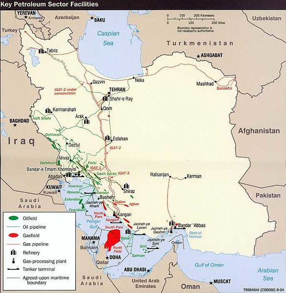
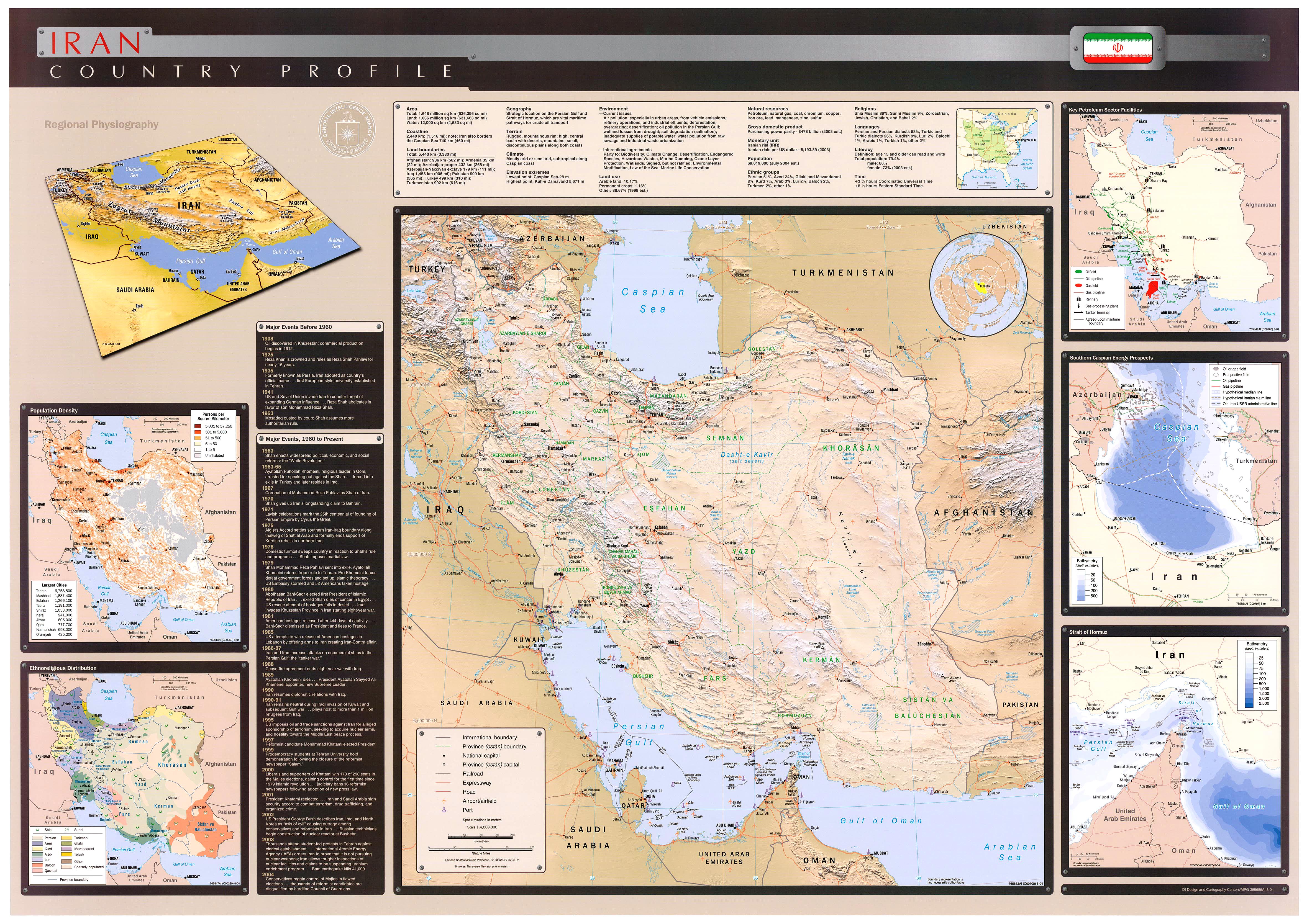
English: Key Petroleum Sector facilities (2004)
Iran (Wall Map) 2004 "Iran Country Profile" Iran map with insets: Population Density, Ethnoreligious Distribution, Key Petroleum Sector Facilities, Southern Caspian Energy Prospects and Strait Of Hormuz (2.5M) (source: CIA map) http://www.lib.utexas.edu/maps/middle_east_and_asia/iran_country_profile_2004.jpg |
| ရင်းမြစ် | CIA World Fact Book |
| စာရေးသူ | CIA |
လိုင်စင်သတ်မှတ်ခြင်း
| This image is a work of a Central Intelligence Agency employee, taken or made as part of that person's official duties. As a Work of the United States Government, this image or media is in the public domain in the United States.
|

|
မူရင်းတင်ထားသောမှတ်တမ်း
ဖော်ပြချက် မူရင်းစာမျက်နှာမှာ here ဖြစ်သည်။ အောက်ပါအသုံးပြုသူ အမည်များအားလုံးသည် en.wikipedia ကို ရည်ညွှန်းသည်။
- 2008-10-20 07:34 SSZ 687×705× (52497 bytes) Key Petroleum Sector facilities (2004) Iran (Wall Map) 2004 "Iran Country Profile" Iran map with insets: Population Density, Ethnoreligious Distribution, Key Petroleum Sector Facilities, Southern Caspian Energy Prospects and Strait Of Hormuz (2.5M) (sour
ဖိုင်မှတ်တမ်း
ဖိုင်ကို ယင်းနေ့စွဲ အတိုင်း မြင်နိုင်ရန် နေ့စွဲ/အချိန် တစ်ခုခုပေါ်တွင် ကလစ်နှိပ်ပါ။
| နေ့စွဲ/အချိန် | နမူနာပုံငယ် | မှတ်တမ်း ဒိုင်မန်းရှင်းများ | အသုံးပြုသူ | မှတ်ချက် | |
|---|---|---|---|---|---|
| ကာလပေါ် | ၀၄:၅၉၊ ၈ အောက်တိုဘာ ၂၀၀၉ | | ၆၈၇ × ၇၀၅ (၅၁ KB) | File Upload Bot (Magnus Manske) | {{BotMoveToCommons|en.wikipedia|year={{subst:CURRENTYEAR}}|month={{subst:CURRENTMONTHNAME}}|day={{subst:CURRENTDAY}}}} {{Information |Description={{en|Key Petroleum Sector facilities (2004) Iran (Wall Map) 2004 "Iran Country Profile" Iran map with inset |
ဖိုင်သုံးစွဲမှု
အောက်ပါ 2 စာမျက်နှာများ သည် ဤဖိုင်ကို အသုံးပြုထားသည်:
ဂလိုဘယ် ဖိုင်သုံးစွဲမှု
အောက်ပါ အခြားဝီကီများတွင် ဤဖိုင်ကို အသုံးပြုထားသည်-
- ar.wikipedia.org တွင် အသုံးပြုမှု
- مضيق هرمز
- برنامج إيران النووي
- منشآت نووية في إيران
- شركة النفط الإنجليزية الفارسية
- العقوبات المفروضة على إيران
- محطة بوشهر الكهروذرية
- حقل غاز الشمال
- اقتصاد إيران
- خط أنابيب تبريز-أنقرة
- خط أنابيب إيران-أرمينيا
- خط أنابيب دولة أباد-سرخس-خانكيران
- عسلوية
- الشركة الوطنية الإيرانية للنفط
- خطة ترشيد البنزين في إيران في عام 2007
- النفط في إيران
- منظمة الطاقة الذرية الإيرانية
- مفاعل أراك للماء الثقيل
- قالب:الطاقة في إيران
- منتدى الدول المصدرة للغاز
- خط أنابيب غاز إيران - باكستان
- خط أنابيب بين العراق وايران وسوريا
- الشركة الوطنية الإيرانية لتكرير وتوزيع النفط
- وزارة النفط (إيران)
- احتياطيات النفط في إيران
- احتياطيات الغاز الطبيعي في إيران
- الشركة الوطنية الإيرانية للغاز
- الشركة الوطنية الإيرانية للبتروكيماويات
- بورصة النفط الإيرانية
- تاريخ إيران الاقتصادي
- الشركة الوطنية الإيرانية لنفط الجنوب
- نفط إيران للتجارة الدولية
- شركة النفط البحرية الإيرانية
- شركة حقول النفط الإيرانية المركزية
- أزارأب للصناعات
- الطاقة في إيران
- مجموعة مابنا
- شركة الناقلات الإيرانية الوطنية
- إيران للغاز الطبيعي المسال
- الفارسية للغاز الطبيعي المسال
- وزارة الطاقة (إيران)
- azb.wikipedia.org တွင် အသုံးပြုမှု
- cs.wikipedia.org တွင် အသုံးပြုမှု
- el.wikipedia.org တွင် အသုံးပြုမှု
- en.wikipedia.org တွင် အသုံးပြုမှု
ဤဖိုင်ကို အခြားနေရာများတွင် အသုံးပြုထားမှုများအား ကြည့်ရှုရန်။