
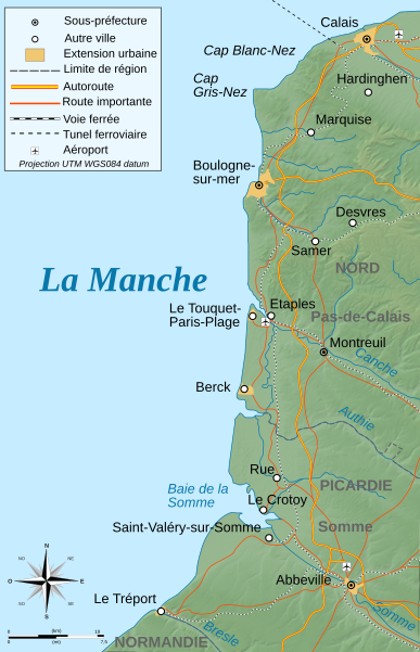
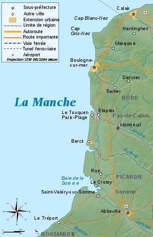
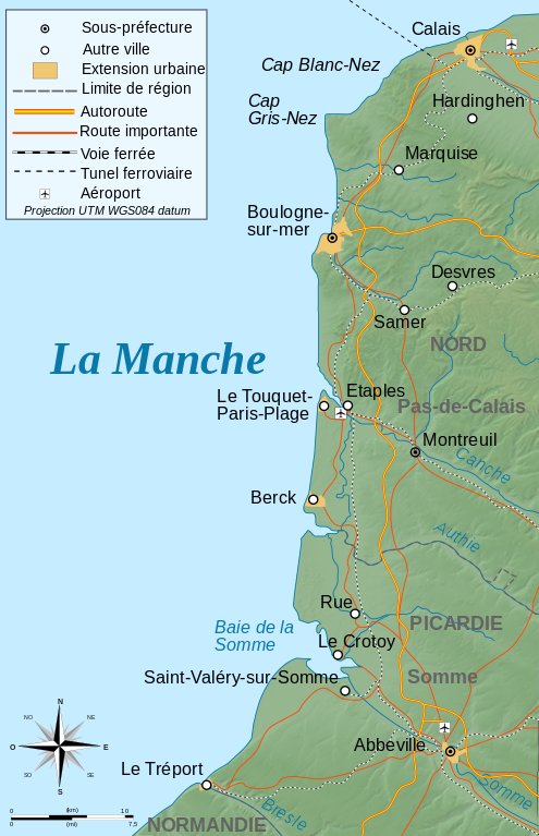
ဖိုင်:Côte d'Opale topographic map-fr.svg

Size of this PNG preview of this SVG file: ၃၈၇ × ၆၀၀ ပစ်ဇယ်. အခြား ပုံရိပ်ပြတ်သားမှု: ၁၅၅ × ၂၄၀ ပစ်ဇယ် | ၃၁၀ × ၄၈၀ ပစ်ဇယ် | ၄၉၅ × ၇၆၈ ပစ်ဇယ် | ၆၆၀ × ၁၀၂၄ ပစ်ဇယ် | ၁၃၂၁ × ၂၀၄၈ ပစ်ဇယ် | ၇၇၁ × ၁၁၉၅ ပစ်ဇယ်။
မူရင်းဖိုင် (SVG ဖိုင်, ၇၇၁ × ၁၁၉၅ pixels ကို အကြံပြုသည်, ဖိုင်အရွယ်အစား - ၂.၀၃ MB)
| ဤဖိုင်သည် Wikimedia Commons မှဖြစ်ပြီး အခြားပရောဂျက်များတွင် သုံးကောင်းသုံးလိမ့်မည်။ ယင်း၏ ဖိုင်အကြောင်းစာမျက်နှာ တွင် ဖော်ပြထားချက်ကို အောက်တွင် ပြထားသည်။ Commons သည် မူပိုင်ခွင့်လွတ်လပ်သော မီဒီယာဖိုင်များ သိုလှောင်ထားရာ နေရာ ဖြစ်သည်။ သင်လည်း ပါဝင်ကူညီနိုင်ပါသည်။ |
အကျဉ်းချုပ်
| ဖော်ပြချက် |
Deutsch: Topographische Karte von Côte d'Opale, französische Version English: Topographic map in French of Côte d'Opale Français : Carte topographique en français de la Côte d'Opale |
| ရက်စွဲ | |
| ရင်းမြစ် |
English: Own work ; Topographic data from the NASA Shuttle Radar Topography Mission (SRTM3 v.2) (public domain) edited with 3DEM, and vectorized with Inkscape ; UTM projection ; WGS84 datum ; shaded relief (composite image of N-W lightning position) ; Reference used for the additional data : * Rivers, cities, railroads, routes: Demis add-on for World Wind (see the approval e-mail and the Demis forum) + viamichelin for highways ; * Borders and coast : World data bank II ; Note : The relief is a raster image embedded in the SVG file. Français : Création personnelle ; Données topographiques de la NASA Shuttle Radar Topography Mission (SRTM3 v.2) (domaine public) éditées avec 3DEM et vectorisées avec Inkscape ; projection UTM ; WGS84 datum ; relief ombré (éclairage du N-O) ; Références utilisées pour les données complémentaires : * Rivières, villes, chemins de fers, routes : Demis add-on for World Wind (see the approval e-mail and the Demis forum) + viamichelin pour les autoroutes ; * Frontières et côtes : World data bank II ; Note : Le relief est une image bitmap embarquée dans le fichier SVG. Approximate geographic limits of the map (30" close) : * SW corner : 49°99'00"N – 01°00'00"E * SE corner : 59°99'00"N – 01°99'00"E * NE corner : 51°00'00"N – 1°99'00"E * NW corner : 51°00'00"N – 1°00'00"E |
| စာရေးသူ | Bourrichon - fr:Bourrichon) |
| ခွင့်ပြုချက် (ဤဖိုင်ကို ပြန်လည်အသုံးပြုခြင်း) |
GFDL / Attribution and Share-Alike required |

|
This SVG file contains embedded text that can be translated into your language, using any capable SVG editor, text editor or the SVG Translate tool. For more information see: About translating SVG files. |
လိုင်စင်သတ်မှတ်ခြင်း
ကျွန်ုပ်၊ ဤလုပ်ဆောင်ချက်၏ မူပိုင်ခွင့်ပိုင်ရှင်အနေဖြင့် ဤနေရာမှ အောက်ပါလိုင်စင်များအောက်တွင် ထုတ်လွှင့်ပါသည်:

|
ဤစာတမ်းကို GNU Free Documentation License, ဗားရှင်း ၁.၂ သို့မဟုတ် Free Software Foundation မှ ဖြန့်ချီထားသော မည်သည့်ယခင်ဗားရှင်းတစ်ခုခုအောက်တွင် Invariant Sections, Front-Cover Texts နှင့် Back-Cover Texts များမပါဝင်ဘဲ ကူးယူခြင်း၊ ဖြန့်ချီခြင်း နှင့်/သို့မဟုတ် ပြင်ဆင်ပြောင်းလဲနိုင်ရန် ခွင့်ပြုသည်။ လိုင်စင်မူပွားကို GNU Free Documentation License ခေါင်းစဉ်အောက်တွင် ထည့်သွင်းထားသည်။ |
This file is licensed under the Creative Commons Attribution-Share Alike 4.0 International, 3.0 Unported, 2.5 Generic, 2.0 Generic and 1.0 Generic license.
- သင်သည် လွတ်လပ်စွာ:
- မျှဝေရန် – ဖန်တီးမှုကို ကူးယူရန်၊ ဖြန့်ဖြူးရန်နှင့် ထုတ်လွှင့်ရန်
- ပြန်ရောနှောရန် – ဖန်တီးမှုကို ပြင်ဆင်ညှိနှိုင်းရန်
- အောက်ပါ အခြေအနေများတွင်:
- မှတ်ယူနိုင်ခြင်း – ပြောင်းလဲမှုများ ပြုလုပ်ခဲ့ပါက ဖန်တီးသူ သို့မဟုတ် လိုင်စင်ရှိသူမှ သတ်မှတ်သော အမျိုးအစားကို လိုက်နာရမည် (ဆိုလိုသည်မှာ သင့်အား သို့မဟုတ် သင့်ဖန်တီးမှုတွင် အသုံးပြုခြင်းအား ထောက်ခံချက်ပေးသည်ဟု မဆိုလိုပါ)။
- ထပ်တူမျှဝေ – ဤဖန်တီးမှုအား ပြင်ဆင်ခြင်း၊ ပြောင်းလဲခြင်း သို့မဟုတ် ထပ်ဆင့် ဖန်တီးခြင်း ပြုလုပ်ပါက ရရှိလာသော ဖန်တီးမှုကို ဤဖန်တီးမှုနှင့် သို့မဟုတ် ဆင်တူသော လိုင်စင်ဖြင့်သာ ဖြန့်ချိသင့်သည်။
သင်အလိုရှိရာ လိုင်စင်ကို ရွေးချယ်နိုင်ပါသည်။
ဖိုင်မှတ်တမ်း
ဖိုင်ကို ယင်းနေ့စွဲ အတိုင်း မြင်နိုင်ရန် နေ့စွဲ/အချိန် တစ်ခုခုပေါ်တွင် ကလစ်နှိပ်ပါ။
| နေ့စွဲ/အချိန် | နမူနာပုံငယ် | မှတ်တမ်း ဒိုင်မန်းရှင်းများ | အသုံးပြုသူ | မှတ်ချက် | |
|---|---|---|---|---|---|
| ကာလပေါ် | ၁၂:၅၇၊ ၇ မတ် ၂၀၀၉ | | ၇၇၁ × ၁၁၉၅ (၂.၀၃ MB) | Bourrichon | + corr erreur |
| ၁၂:၅၀၊ ၇ မတ် ၂၀၀၉ |  | ၇၇၁ × ၁၁၉၅ (၁၅၉ KB) | Bourrichon | == Summary == {{Information |Description={{de|Topographische Karte von Côte d'Opale, französische Version}}{{en|Topographic map in French of Côte d'Opale}}{{fr|Carte topographique en français de la [[:fr:Cô |
ဖိုင်သုံးစွဲမှု
ဤဖိုင်ကို အသုံးပြုထားသော စာမျက်နှာများမရှိပါ။
ဂလိုဘယ် ဖိုင်သုံးစွဲမှု
အောက်ပါ အခြားဝီကီများတွင် ဤဖိုင်ကို အသုံးပြုထားသည်-
- bg.wikipedia.org တွင် အသုံးပြုမှု
- de.wikipedia.org တွင် အသုံးပြုမှု
- en.wikipedia.org တွင် အသုံးပြုမှု
- eo.wikipedia.org တွင် အသုံးပြုမှု
- es.wikipedia.org တွင် အသုံးပြုမှု
- fr.wikipedia.org တွင် အသုံးပြုမှု
- Étaples
- Le Touquet-Paris-Plage
- Baie de Somme
- Côte d'Opale
- Poulier
- Parc naturel marin des estuaires picards et de la mer d'Opale
- Dunes d'Écault
- Berck (Pas-de-Calais)
- Portail:Boulogne-sur-Mer
- Plage du Touquet-Paris-Plage
- Portail:Côte d'Opale
- Unité urbaine de Berck
- Portail:Côte d'Opale/Introduction
- Portail:Le Touquet-Paris-Plage
- Portail:Le Touquet-Paris-Plage/Index thématique
- Portail:Boulogne-sur-Mer/Index thématique
- Wikipédia:Atelier graphique/Cartes/Archives/mai 2017
- Opération Undergo
- Modèle:Géolocalisation/Côte d'Opale
- hu.wikipedia.org တွင် အသုံးပြုမှု
- it.wikipedia.org တွင် အသုံးပြုမှု
- nl.wikipedia.org တွင် အသုံးပြုမှု
- pcd.wikipedia.org တွင် အသုံးပြုမှု
- pl.wikipedia.org တွင် အသုံးပြုမှု
- ro.wikipedia.org တွင် အသုံးပြုမှု
- vls.wikipedia.org တွင် အသုံးပြုမှု
- www.wikidata.org တွင် အသုံးပြုမှု