
ဖိုင်:Atlantikwall.png
ဤနမူနာ၏ အရွယ်အစား - ၄၅၆ × ၅၉၉ ပစ်ဇယ်။ အခြား ပုံရိပ်ပြတ်သားမှု: ၁၈၃ × ၂၄၀ ပစ်ဇယ် | ၆၁၂ × ၈၀၄ ပစ်ဇယ်။
မူရင်းဖိုင် (၆၁၂ × ၈၀၄ pixels, ဖိုင်အရွယ်အစား - ၇၉ KB, MIME အမျိုးအစား image/png)
| ဤဖိုင်သည် Wikimedia Commons မှဖြစ်ပြီး အခြားပရောဂျက်များတွင် သုံးကောင်းသုံးလိမ့်မည်။ ယင်း၏ ဖိုင်အကြောင်းစာမျက်နှာ တွင် ဖော်ပြထားချက်ကို အောက်တွင် ပြထားသည်။ Commons သည် မူပိုင်ခွင့်လွတ်လပ်သော မီဒီယာဖိုင်များ သိုလှောင်ထားရာ နေရာ ဖြစ်သည်။ သင်လည်း ပါဝင်ကူညီနိုင်ပါသည်။ |

|
This military map image could be re-created using vector graphics as an SVG file. This has several advantages; see Commons:Media for cleanup for more information. If an SVG form of this image is available, please upload it and afterwards replace this template with
{{vector version available|new image name}}.
It is recommended to name the SVG file “Atlantikwall.svg”—then the template Vector version available (or Vva) does not need the new image name parameter. |
| ဖော်ပြချက် |
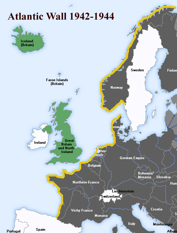
English: The Atlantic Wall (defence built by Nazi Germany, stood from 1942-44). Deutsch: Der Atlantikwall, eine 2.685 km lange Linie von befestigten Stellungen entlang der Küsten des Atlantiks, Ärmelkanals und der Nordsee, 1942-44. |
||||||||
| ရက်စွဲ | |||||||||
| ရင်းမြစ် | English Wikipedia, File:Atlantic-Wall.gif | ||||||||
| စာရေးသူ | User:Uberstroker | ||||||||
| ခွင့်ပြုချက် (ဤဖိုင်ကို ပြန်လည်အသုံးပြုခြင်း) |
Uberstroker၊ ဤလုပ်ဆောင်ချက်၏ မူပိုင်ခွင့်ပိုင်ရှင်အနေဖြင့် ဤနေရာမှ အောက်ပါလိုင်စင်အောက်တွင် ထုတ်လွှင့်ပါသည်:
|
||||||||
| အခြား ဗားရှင်းများ | [1] |

![[1]](https://en.wikipedia.org/wiki/Image:Atlantic-Wall.gif)
မူရင်းတင်ထားသောမှတ်တမ်း
| နေ့စွဲ/အချိန် | မှတ်တမ်း ဒိုင်မန်းရှင်းများ | အသုံးပြုသူ | မှတ်ချက် |
|---|---|---|---|
| ၁၄ ဧပြီ ၂၀၀၇, ၀၁:၅၄:၁၆ | 612 × 804 (61489 bytes) | Responsible? (ဆွေးနွေး · ပံ့ပိုး) | {{Information |Description={{en|The '''Atlantic Wall''' (defence built by Nazi Germany, stood from 1942-44}} <br> {{de|Der '''Atlantikwall''', eine 2.685 km lange Linie von befestigten Stellungen entlang der Küsten des Atlantiks, Ärmelkanals und der Nor |
ဖိုင်မှတ်တမ်း
ဖိုင်ကို ယင်းနေ့စွဲ အတိုင်း မြင်နိုင်ရန် နေ့စွဲ/အချိန် တစ်ခုခုပေါ်တွင် ကလစ်နှိပ်ပါ။
| နေ့စွဲ/အချိန် | နမူနာပုံငယ် | မှတ်တမ်း ဒိုင်မန်းရှင်းများ | အသုံးပြုသူ | မှတ်ချက် | |
|---|---|---|---|---|---|
| ကာလပေါ် | ၁၄:၂၃၊ ၁၉ ဧပြီ ၂၀၁၅ | | ၆၁၂ × ၈၀၄ (၇၉ KB) | Hohum | Enhance blue |
| ၀၁:၁၇၊ ၁၉ စက်တင်ဘာ ၂၀၁၄ |  | ၆၁၂ × ၈၀၄ (၈၀ KB) | Hohum | Clearer | |
| ၁၅:၄၅၊ ၁၈ ဩဂုတ် ၂၀၁၄ |  | ၆၁၂ × ၈၀၄ (၆၅ KB) | GifTagger | Bot: Converting file to superior PNG file. (Source: Atlantikwall.gif). This GIF was problematic due to non-greyscale color table. |
ဖိုင်သုံးစွဲမှု
ဤဖိုင်ကို အသုံးပြုထားသော စာမျက်နှာများမရှိပါ။
ဂလိုဘယ် ဖိုင်သုံးစွဲမှု
အောက်ပါ အခြားဝီကီများတွင် ဤဖိုင်ကို အသုံးပြုထားသည်-
- ar.wikipedia.org တွင် အသုံးပြုမှု
- azb.wikipedia.org တွင် အသုံးပြုမှု
- az.wikipedia.org တွင် အသုံးပြုမှု
- bg.wikipedia.org တွင် အသုံးပြုမှု
- bn.wikipedia.org တွင် အသုံးပြုမှု
- br.wikipedia.org တွင် အသုံးပြုမှု
- ca.wikipedia.org တွင် အသုံးပြုမှု
- da.wikipedia.org တွင် အသုံးပြုမှု
- diq.wikipedia.org တွင် အသုံးပြုမှု
- el.wikipedia.org တွင် အသုံးပြုမှု
- en.wikipedia.org တွင် အသုံးပြုမှု
- eo.wikipedia.org တွင် အသုံးပြုမှု
- et.wikipedia.org တွင် အသုံးပြုမှု
- eu.wikipedia.org တွင် အသုံးပြုမှု
- fa.wikipedia.org တွင် အသုံးပြုမှု
- fi.wikipedia.org တွင် အသုံးပြုမှု
- fr.wikipedia.org တွင် အသုံးပြုမှု
- fy.wikipedia.org တွင် အသုံးပြုမှု
- hy.wikipedia.org တွင် အသုံးပြုမှု
- id.wikipedia.org တွင် အသုံးပြုမှု
- it.wikipedia.org တွင် အသုံးပြုမှု
- ja.wikipedia.org တွင် အသုံးပြုမှု
- ka.wikipedia.org တွင် အသုံးပြုမှု
- lv.wikipedia.org တွင် အသုံးပြုမှု
- mk.wikipedia.org တွင် အသုံးပြုမှု
- mr.wikipedia.org တွင် အသုံးပြုမှု
- ms.wikipedia.org တွင် အသုံးပြုမှု
- nl.wikipedia.org တွင် အသုံးပြုမှု
- nn.wikipedia.org တွင် အသုံးပြုမှု
- no.wikipedia.org တွင် အသုံးပြုမှု
- pt.wikipedia.org တွင် အသုံးပြုမှု
- ro.wikipedia.org တွင် အသုံးပြုမှု
ဤဖိုင်ကို အခြားနေရာများတွင် အသုံးပြုထားမှုများအား ကြည့်ရှုရန်။