
ဖိုင်:Argentina topo blank.jpg

ဤနမူနာ၏ အရွယ်အစား - ၄၄၅ × ၅၉၉ ပစ်ဇယ်။ အခြား ပုံရိပ်ပြတ်သားမှု: ၁၇၈ × ၂၄၀ ပစ်ဇယ် | ၃၅၇ × ၄၈၀ ပစ်ဇယ် | ၅၇၁ × ၇၆၈ ပစ်ဇယ် | ၇၆၁ × ၁၀၂၄ ပစ်ဇယ် | ၁၆၀၀ × ၂၁၅၃ ပစ်ဇယ်။
မူရင်းဖိုင် (၁၆၀၀ × ၂၁၅၃ pixels, ဖိုင်အရွယ်အစား - ၅၆၅ KB, MIME အမျိုးအစား image/jpeg)
| ဤဖိုင်သည် Wikimedia Commons မှဖြစ်ပြီး အခြားပရောဂျက်များတွင် သုံးကောင်းသုံးလိမ့်မည်။ ယင်း၏ ဖိုင်အကြောင်းစာမျက်နှာ တွင် ဖော်ပြထားချက်ကို အောက်တွင် ပြထားသည်။ Commons သည် မူပိုင်ခွင့်လွတ်လပ်သော မီဒီယာဖိုင်များ သိုလှောင်ထားရာ နေရာ ဖြစ်သည်။ သင်လည်း ပါဝင်ကူညီနိုင်ပါသည်။ |
| ဖော်ပြချက် |
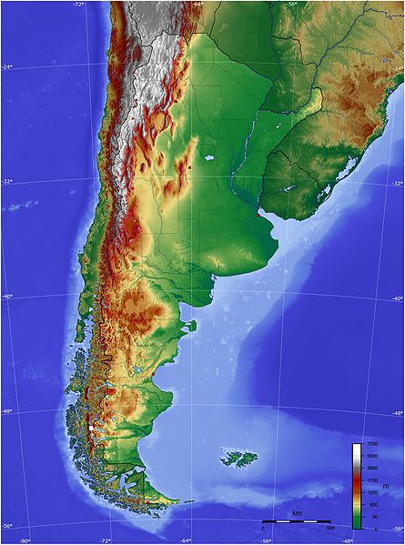
Español: Mapa de Argentina con su relieve
English: Map of Argentina with its terrain levels |
||||||||||
| ရက်စွဲ | 9/06/2006 | ||||||||||
| ရင်းမြစ် | See below | ||||||||||
| စာရေးသူ | Captain Blood | ||||||||||
| ခွင့်ပြုချက် (ဤဖိုင်ကို ပြန်လည်အသုံးပြုခြင်း) |
|

ဖိုင်မှတ်တမ်း
ဖိုင်ကို ယင်းနေ့စွဲ အတိုင်း မြင်နိုင်ရန် နေ့စွဲ/အချိန် တစ်ခုခုပေါ်တွင် ကလစ်နှိပ်ပါ။
| နေ့စွဲ/အချိန် | နမူနာပုံငယ် | မှတ်တမ်း ဒိုင်မန်းရှင်းများ | အသုံးပြုသူ | မှတ်ချက် | |
|---|---|---|---|---|---|
| ကာလပေါ် | ၂၁:၄၅၊ ၁၃ မေ ၂၀၀၉ | | ၁၆၀၀ × ၂၁၅၃ (၅၆၅ KB) | Keysanger | reverted. (Deleted yellow line in the Straits of Magellan, added the definitive end of the controversial border at the Beagle Channel and marked with a white box the (last) undefined border zone as agreed both countries.) |
| ၀၄:၁၀၊ ၅ မေ ၂၀၀၉ |  | ၁၆၀၀ × ၂၁၅၃ (၈၆၇ KB) | Dexxter | Reverted to version as of 18:57, 9 June 2006 | |
| ၂၀:၁၃၊ ၄ ဇွန် ၂၀၀၈ |  | ၁၆၀၀ × ၂၁၅၃ (၅၆၅ KB) | Keysanger | Argentina topo deleted yellow line in the Straits of Magellan, added the definitive end of the controversial border at the Beagle Channel and marked with a white box the (last) undefined border zone as agreed both countries. [[Category:[[Category:Topograp | |
| ၁၈:၅၇၊ ၉ ဇွန် ၂၀၀၆ |  | ၁၆၀၀ × ၂၁၅၃ (၈၆၇ KB) | Captain Blood~commonswiki | {{Bild-GFDL-GMT}} |
ဖိုင်သုံးစွဲမှု
ဤဖိုင်ကို အသုံးပြုထားသော စာမျက်နှာများမရှိပါ။
ဂလိုဘယ် ဖိုင်သုံးစွဲမှု
အောက်ပါ အခြားဝီကီများတွင် ဤဖိုင်ကို အသုံးပြုထားသည်-
- bg.wikipedia.org တွင် အသုံးပြုမှု
- bn.wikipedia.org တွင် အသုံးပြုမှု
- ca.wikipedia.org တွင် အသုံးပြုမှု
- ckb.wikipedia.org တွင် အသုံးပြုမှု
- dz.wikipedia.org တွင် အသုံးပြုမှု
- ee.wikipedia.org တွင် အသုံးပြုမှု
- el.wikipedia.org တွင် အသုံးပြုမှု
- en.wikipedia.org တွင် အသုံးပြုမှု
- eo.wikipedia.org တွင် အသုံးပြုမှု
- es.wikipedia.org တွင် အသုံးပြုမှု
- eu.wikipedia.org တွင် အသုံးပြုမှု
- fa.wikipedia.org တွင် အသုံးပြုမှု
- fi.wikipedia.org တွင် အသုံးပြုမှု
- fr.wikipedia.org တွင် အသုံးပြုမှု
- gcr.wikipedia.org တွင် အသုံးပြုမှု
- hu.wikipedia.org တွင် အသုံးပြုမှု
- hy.wikipedia.org တွင် အသုံးပြုမှု
- incubator.wikimedia.org တွင် အသုံးပြုမှု
- io.wikipedia.org တွင် အသုံးပြုမှု
- it.wikipedia.org တွင် အသုံးပြုမှု
- ja.wikipedia.org တွင် အသုံးပြုမှု
- ka.wikipedia.org တွင် အသုံးပြုမှု
- kbd.wikipedia.org တွင် အသုံးပြုမှု
- ko.wikipedia.org တွင် အသုံးပြုမှု
- ml.wikipedia.org တွင် အသုံးပြုမှု
- ms.wikipedia.org တွင် အသုံးပြုမှု
- mt.wikipedia.org တွင် အသုံးပြုမှု
- pl.wikipedia.org တွင် အသုံးပြုမှု
- pt.wikipedia.org တွင် အသုံးပြုမှု
ဤဖိုင်ကို အခြားနေရာများတွင် အသုံးပြုထားမှုများအား ကြည့်ရှုရန်။