
ဖိုင်:Antipodes equirectangular.svg

Size of this PNG preview of this SVG file: ၈၀၀ × ၄၀၀ ပစ်ဇယ်. အခြား ပုံရိပ်ပြတ်သားမှု: ၃၂၀ × ၁၆၀ ပစ်ဇယ် | ၆၄၀ × ၃၂၀ ပစ်ဇယ် | ၁၀၂၄ × ၅၁၂ ပစ်ဇယ် | ၁၂၈၀ × ၆၄၀ ပစ်ဇယ် | ၂၅၆၀ × ၁၂၈၀ ပစ်ဇယ် | ၁၈၀၀ × ၉၀၀ ပစ်ဇယ်။
မူရင်းဖိုင် (SVG ဖိုင်, ၁၈၀၀ × ၉၀၀ pixels ကို အကြံပြုသည်, ဖိုင်အရွယ်အစား - ၈၃ KB)
| ဤဖိုင်သည် Wikimedia Commons မှဖြစ်ပြီး အခြားပရောဂျက်များတွင် သုံးကောင်းသုံးလိမ့်မည်။ ယင်း၏ ဖိုင်အကြောင်းစာမျက်နှာ တွင် ဖော်ပြထားချက်ကို အောက်တွင် ပြထားသည်။ Commons သည် မူပိုင်ခွင့်လွတ်လပ်သော မီဒီယာဖိုင်များ သိုလှောင်ထားရာ နေရာ ဖြစ်သည်။ သင်လည်း ပါဝင်ကူညီနိုင်ပါသည်။ |
အကျဉ်းချုပ်
| ဖော်ပြချက် |
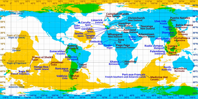
English: Cities and towns which are near antipodes in equirectangular projection. Blue labels correspond to the cyan areas and brown labels correspond to the yellow areas. Areas where blue and yellow overlap (coloured green) are land antipodes. |
| ရင်းမြစ် | ကိုယ်ပိုင်ဖန်တီးမှု |
| စာရေးသူ | Cmglee |
| အခြား ဗားရှင်းများ | File:Antipodes LAEA.png, File:Antipodes LAEA inverted.png, File:WorldMapWithAntipodes.png, |
လိုင်စင်သတ်မှတ်ခြင်း
ကျွန်ုပ်၊ ဤလုပ်ဆောင်ချက်၏ မူပိုင်ခွင့်ပိုင်ရှင်အနေဖြင့် ဤနေရာမှ အောက်ပါလိုင်စင်အောက်တွင် ထုတ်လွှင့်ပါသည်:
ဤဖိုင်ကို Creative Commons Attribution-Share Alike 3.0 Unported လိုင်စင်ဖြင့် သတ်မှတ်ထားသည်။
- သင်သည် လွတ်လပ်စွာ:
- မျှဝေရန် – ဖန်တီးမှုကို ကူးယူရန်၊ ဖြန့်ဖြူးရန်နှင့် ထုတ်လွှင့်ရန်
- ပြန်ရောနှောရန် – ဖန်တီးမှုကို ပြင်ဆင်ညှိနှိုင်းရန်
- အောက်ပါ အခြေအနေများတွင်:
- မှတ်ယူနိုင်ခြင်း – ပြောင်းလဲမှုများ ပြုလုပ်ခဲ့ပါက ဖန်တီးသူ သို့မဟုတ် လိုင်စင်ရှိသူမှ သတ်မှတ်သော အမျိုးအစားကို လိုက်နာရမည် (ဆိုလိုသည်မှာ သင့်အား သို့မဟုတ် သင့်ဖန်တီးမှုတွင် အသုံးပြုခြင်းအား ထောက်ခံချက်ပေးသည်ဟု မဆိုလိုပါ)။
- ထပ်တူမျှဝေ – ဤဖန်တီးမှုအား ပြင်ဆင်ခြင်း၊ ပြောင်းလဲခြင်း သို့မဟုတ် ထပ်ဆင့် ဖန်တီးခြင်း ပြုလုပ်ပါက ရရှိလာသော ဖန်တီးမှုကို ဤဖန်တီးမှုနှင့် သို့မဟုတ် ဆင်တူသော လိုင်စင်ဖြင့်သာ ဖြန့်ချိသင့်သည်။
ဖိုင်မှတ်တမ်း
ဖိုင်ကို ယင်းနေ့စွဲ အတိုင်း မြင်နိုင်ရန် နေ့စွဲ/အချိန် တစ်ခုခုပေါ်တွင် ကလစ်နှိပ်ပါ။
| နေ့စွဲ/အချိန် | နမူနာပုံငယ် | မှတ်တမ်း ဒိုင်မန်းရှင်းများ | အသုံးပြုသူ | မှတ်ချက် | |
|---|---|---|---|---|---|
| ကာလပေါ် | ၁၀:၂၇၊ ၁၉ မေ ၂၀၁၁ | | ၁၈၀၀ × ၉၀၀ (၈၃ KB) | AnonMoos | trivial changes to increase default display size, remove unused code |
| ၂၃:၂၇၊ ၂၄ မတ် ၂၀၁၁ |  | ၅၁၂ × ၂၅၆ (၉၁ KB) | Cmglee | Move labels to reduce overlap, add new places and brighten bitmap. | |
| ၀၈:၅၀၊ ၂၄ မတ် ၂၀၁၁ |  | ၅၁၂ × ၂၅၆ (၈၉ KB) | Cmglee | {{Information |Description ={{en|1=Cities and towns which are near antipodes in equirectangular projection. }} |Source ={{own}} |Author =Cmglee |Date = |Permission = |other_versions = }} [[Category:Maps of |
ဖိုင်သုံးစွဲမှု
ဤဖိုင်ကို အသုံးပြုထားသော စာမျက်နှာများမရှိပါ။
ဂလိုဘယ် ဖိုင်သုံးစွဲမှု
အောက်ပါ အခြားဝီကီများတွင် ဤဖိုင်ကို အသုံးပြုထားသည်-
- de.wikipedia.org တွင် အသုံးပြုမှု
- en.wikipedia.org တွင် အသုံးပြုမှု
- et.wikipedia.org တွင် အသုံးပြုမှု
- pl.wikipedia.org တွင် အသုံးပြုမှု