
ဖိုင်:Aerial View of Damavand 26.11.2008 04-25-38.JPG

ဤနမူနာ၏ အရွယ်အစား - ၈၀၀ × ၆၀၀ ပစ်ဇယ်။ အခြား ပုံရိပ်ပြတ်သားမှု: ၃၂၀ × ၂၄၀ ပစ်ဇယ် | ၆၄၀ × ၄၈၀ ပစ်ဇယ် | ၁၀၂၄ × ၇၆၈ ပစ်ဇယ် | ၁၂၈၀ × ၉၆၀ ပစ်ဇယ် | ၂၀၄၈ × ၁၅၃၆ ပစ်ဇယ်။
မူရင်းဖိုင် (၂၀၄၈ × ၁၅၃၆ pixels, ဖိုင်အရွယ်အစား - ၁.၇၉ MB, MIME အမျိုးအစား image/jpeg)
| ဤဖိုင်သည် Wikimedia Commons မှဖြစ်ပြီး အခြားပရောဂျက်များတွင် သုံးကောင်းသုံးလိမ့်မည်။ ယင်း၏ ဖိုင်အကြောင်းစာမျက်နှာ တွင် ဖော်ပြထားချက်ကို အောက်တွင် ပြထားသည်။ Commons သည် မူပိုင်ခွင့်လွတ်လပ်သော မီဒီယာဖိုင်များ သိုလှောင်ထားရာ နေရာ ဖြစ်သည်။ သင်လည်း ပါဝင်ကူညီနိုင်ပါသည်။ |
အကျဉ်းချုပ်
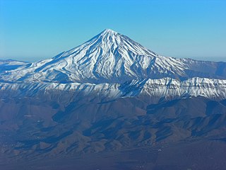
| ဖော်ပြချက် | Aerial View of Damavand |
| ရက်စွဲ | Taken on ၂၆ နိုဝင်ဘာ ၂၀၀၈, ၀၄:၂၅:၃၈ |
| ရင်းမြစ် | ကိုယ်ပိုင်ဖန်တီးမှု |
| စာရေးသူ | Hansueli Krapf |
| ခွင့်ပြုချက် (ဤဖိုင်ကို ပြန်လည်အသုံးပြုခြင်း) |
Attribution ShareAlike 3.0 |
| Camera location | | View this and other nearby images on: OpenStreetMap |
|---|
| Annotations | This image is annotated: View the annotations at Commons |
လိုင်စင်သတ်မှတ်ခြင်း
ဤဖိုင်ကို Creative Commons Attribution-Share Alike 3.0 Unported လိုင်စင်ဖြင့် သတ်မှတ်ထားသည်။
- သင်သည် လွတ်လပ်စွာ:
- မျှဝေရန် – ဖန်တီးမှုကို ကူးယူရန်၊ ဖြန့်ဖြူးရန်နှင့် ထုတ်လွှင့်ရန်
- ပြန်ရောနှောရန် – ဖန်တီးမှုကို ပြင်ဆင်ညှိနှိုင်းရန်
- အောက်ပါ အခြေအနေများတွင်:
- မှတ်ယူနိုင်ခြင်း – ပြောင်းလဲမှုများ ပြုလုပ်ခဲ့ပါက ဖန်တီးသူ သို့မဟုတ် လိုင်စင်ရှိသူမှ သတ်မှတ်သော အမျိုးအစားကို လိုက်နာရမည် (ဆိုလိုသည်မှာ သင့်အား သို့မဟုတ် သင့်ဖန်တီးမှုတွင် အသုံးပြုခြင်းအား ထောက်ခံချက်ပေးသည်ဟု မဆိုလိုပါ)။
- ထပ်တူမျှဝေ – ဤဖန်တီးမှုအား ပြင်ဆင်ခြင်း၊ ပြောင်းလဲခြင်း သို့မဟုတ် ထပ်ဆင့် ဖန်တီးခြင်း ပြုလုပ်ပါက ရရှိလာသော ဖန်တီးမှုကို ဤဖန်တီးမှုနှင့် သို့မဟုတ် ဆင်တူသော လိုင်စင်ဖြင့်သာ ဖြန့်ချိသင့်သည်။
ဖိုင်မှတ်တမ်း
ဖိုင်ကို ယင်းနေ့စွဲ အတိုင်း မြင်နိုင်ရန် နေ့စွဲ/အချိန် တစ်ခုခုပေါ်တွင် ကလစ်နှိပ်ပါ။
| နေ့စွဲ/အချိန် | နမူနာပုံငယ် | မှတ်တမ်း ဒိုင်မန်းရှင်းများ | အသုံးပြုသူ | မှတ်ချက် | |
|---|---|---|---|---|---|
| ကာလပေါ် | ၁၅:၅၀၊ ၂၉ ဒီဇင်ဘာ ၂၀၁၂ | | ၂၀၄၈ × ၁၅၃၆ (၁.၇၉ MB) | Simisa | Changed color temperature |
| ၁၉:၄၇၊ ၁၉ ဇွန် ၂၀၀၉ |  | ၂၀၄၈ × ၁၅၃၆ (၉၂၈ KB) | Simisa | {{Information |Description=Aerial View of Damavand |Source=Own Work |Date=see metadata |Author=Hansueli Krapf |Permission=Attribution ShareAlike 3.0 |other_versions= }} {{cc-by-sa-3.0}} Category:Aerial photographs of Iran [[Category: |
ဖိုင်သုံးစွဲမှု
အောက်ပါ စာမျက်နှာ သည် ဤဖိုင်ကို အသုံးပြုထားသည်:
ဂလိုဘယ် ဖိုင်သုံးစွဲမှု
အောက်ပါ အခြားဝီကီများတွင် ဤဖိုင်ကို အသုံးပြုထားသည်-
- ar.wikipedia.org တွင် အသုံးပြုမှု
- مازندران (محافظة)
- ساري
- نوشهر
- كلاردشت
- جبل دماوند
- بابل (إيران)
- أمل (مازندران)
- جويبار
- شالوس
- رامسر
- بابلسر
- بهشهر
- قائم شهر
- قالب:محافظة مازندران
- نيما يوشيج
- جسر ورسك
- مقاطعة عباس آباد (مازندران)
- عباس آباد (مازندران)
- كلار آباد (مازندران)
- سلمان شهر (مازندران)
- مقاطعة أمل
- مقاطعة بابلسر (مازندران)
- مقاطعة بهشهر
- مقاطعة شالوس
- مقاطعة فريدونكنار (مازندران)
- مقاطعة غلوغاه (مازندران)
- مقاطعة جويبار (مازندران)
- مقاطعة محمود آباد (مازندران)
- مقاطعة مياندورود (مازندران)
- مقاطعة نكا (مازندران)
- مقاطعة نوشهر
- مقاطعة نور
- مقاطعة قائم شهر
- مقاطعة رامسر
- مقاطعة ساري
- مقاطعة سواد كوه
- مقاطعة تنكابن (مازندران)
- تنكابن
- نور (إيران)
- محمود أباد
- رويان (إيران)
- ألشت
- شيرغاه
- تشمستان
- فريدونكنار
- كوهي خيل
- رستمكلا
- زيرأب
- بهنمير
- بلده (إيران)
ဤဖိုင်ကို အခြားနေရာများတွင် အသုံးပြုထားမှုများအား ကြည့်ရှုရန်။