
ဖိုင်:Accreting coast Image6.svg

Size of this PNG preview of this SVG file: ၈၀၀ × ၃၇၇ ပစ်ဇယ်. အခြား ပုံရိပ်ပြတ်သားမှု: ၃၂၀ × ၁၅၁ ပစ်ဇယ် | ၆၄၀ × ၃၀၁ ပစ်ဇယ် | ၁၀၂၄ × ၄၈၂ ပစ်ဇယ် | ၁၂၈၀ × ၆၀၂ ပစ်ဇယ် | ၂၅၆၀ × ၁၂၀၅ ပစ်ဇယ် | ၁၄၈၁ × ၆၉၇ ပစ်ဇယ်။
မူရင်းဖိုင် (SVG ဖိုင်, ၁၄၈၁ × ၆၉၇ pixels ကို အကြံပြုသည်, ဖိုင်အရွယ်အစား - ၁၅ KB)
| ဤဖိုင်သည် Wikimedia Commons မှဖြစ်ပြီး အခြားပရောဂျက်များတွင် သုံးကောင်းသုံးလိမ့်မည်။ ယင်း၏ ဖိုင်အကြောင်းစာမျက်နှာ တွင် ဖော်ပြထားချက်ကို အောက်တွင် ပြထားသည်။ Commons သည် မူပိုင်ခွင့်လွတ်လပ်သော မီဒီယာဖိုင်များ သိုလှောင်ထားရာ နေရာ ဖြစ်သည်။ သင်လည်း ပါဝင်ကူညီနိုင်ပါသည်။ |
အကျဉ်းချုပ်
| ဖော်ပြချက် |
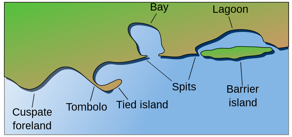
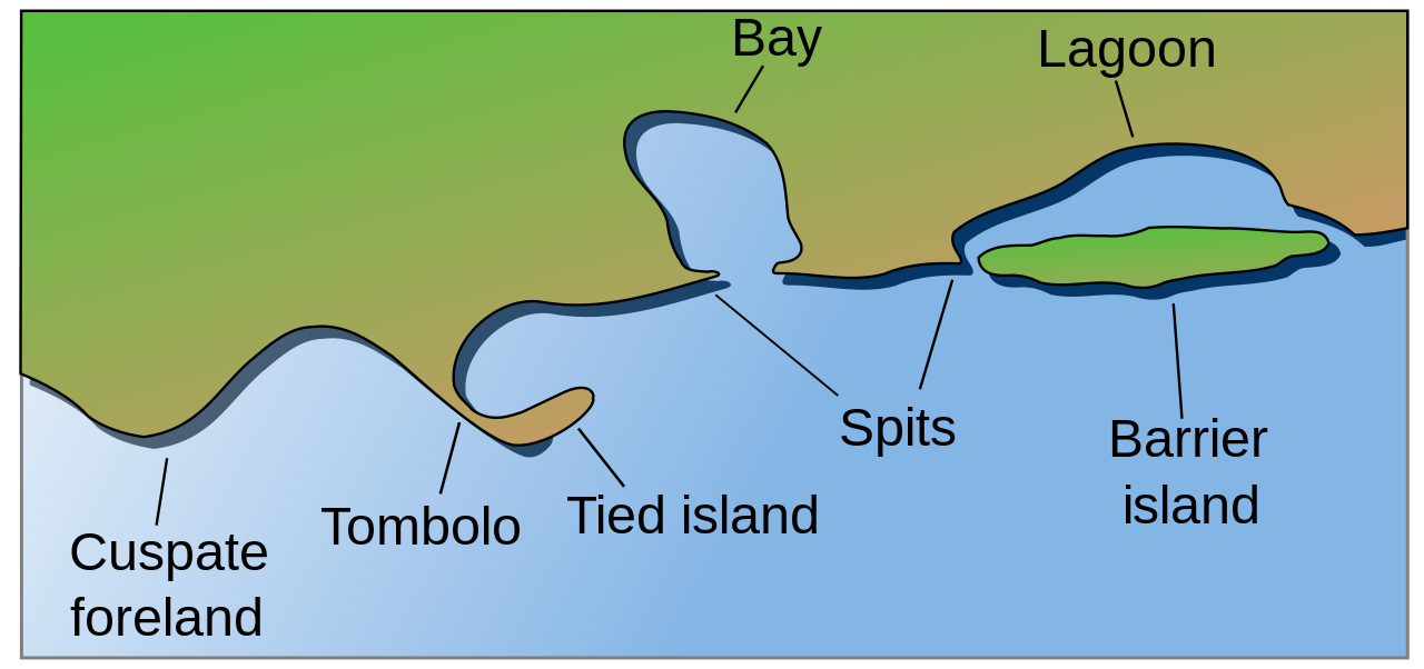
English: Coastal and oceanic landforms. Cuspate foreland, tombolo, spit, bay, lagoon, barrier island. |
| ရက်စွဲ | |
| ရင်းမြစ် | self-made SVG, based on the public domain PNG Accreting coast Image6.png by Feydey |
| စာရေးသူ | Surachit |
| အခြား ဗားရှင်းများ |
Derivative works of this file: Accreting coast Image6-ta.svg
|
| SVG genesis | ဤ SVG ၏ ကုဒ်သည် ခိုင်လုံသည်။ |


လိုင်စင်သတ်မှတ်ခြင်း
| This work has been released into the public domain by its author, Feydey. This applies worldwide. In some countries this may not be legally possible; if so: |
ဖိုင်မှတ်တမ်း
ဖိုင်ကို ယင်းနေ့စွဲ အတိုင်း မြင်နိုင်ရန် နေ့စွဲ/အချိန် တစ်ခုခုပေါ်တွင် ကလစ်နှိပ်ပါ။
| နေ့စွဲ/အချိန် | နမူနာပုံငယ် | မှတ်တမ်း ဒိုင်မန်းရှင်းများ | အသုံးပြုသူ | မှတ်ချက် | |
|---|---|---|---|---|---|
| ကာလပေါ် | ၀၄:၁၇၊ ၁၆ မေ ၂၀၂၂ | | ၁၄၈၁ × ၆၉၇ (၁၅ KB) | Bacon Noodles | Fixed background (water) alignment |
| ၀၁:၄၉၊ ၁၂ ဖေဖော်ဝါရီ ၂၀၁၈ |  | ၁၄၈၁ × ၆၉၇ (၁၅ KB) | Howpper | Added tied island. A Tombolo is what connects a Tied island to the mainland, so it would be exclusive to not include both features. | |
| ၂၁:၄၈၊ ၁၆ ဩဂုတ် ၂၀၀၇ |  | ၁၄၈၁ × ၆၉၇ (၁၃ KB) | Surachit | {{Information |Description=Coastal and oceanic landforms. Cuspate foreland, tombolo, spit, bay, lagoon, barrier island. |Source=self-made SVG, based on the public domain PNG [http://en.wikipedia.org/wiki/Image:Accreting_coast_Image6.png] by [http://en.wik |
ဖိုင်သုံးစွဲမှု
ဤဖိုင်ကို အသုံးပြုထားသော စာမျက်နှာများမရှိပါ။
ဂလိုဘယ် ဖိုင်သုံးစွဲမှု
အောက်ပါ အခြားဝီကီများတွင် ဤဖိုင်ကို အသုံးပြုထားသည်-
- ar.wikipedia.org တွင် အသုံးပြုမှု
- az.wikipedia.org တွင် အသုံးပြုမှု
- bh.wikipedia.org တွင် အသုံးပြုမှု
- chr.wikipedia.org တွင် အသုံးပြုမှု
- cs.wikipedia.org တွင် အသုံးပြုမှု
- en.wikipedia.org တွင် အသုံးပြုမှု
- Archipelago
- Coast
- Dune
- Island
- List of peninsulas
- Beach
- Fjord
- Atoll
- Strait
- Boulder
- Estuary
- Natural arch
- Lagoon
- Coral reef
- Firth
- Isthmus
- Gulf of California
- Coastal erosion
- Talk:Beach
- River delta
- Cliff
- Reef
- Islet
- Salt marsh
- Tombolo
- Stack (geology)
- Cove
- Shoal
- Spit (landform)
- Longshore drift
- Ria
- Barrier island
- Emergent coastline
- Submergent coastline
- Groyne
- Rip current
- Pebble
- Discordant coastline
- Wave-cut platform
ဤဖိုင်ကို အခြားနေရာများတွင် အသုံးပြုထားမှုများအား ကြည့်ရှုရန်။