
ဖိုင်:401 widest point.jpg

ဤနမူနာ၏ အရွယ်အစား - ၈၀၀ × ၅၃၁ ပစ်ဇယ်။ အခြား ပုံရိပ်ပြတ်သားမှု: ၃၂၀ × ၂၁၃ ပစ်ဇယ် | ၆၄၀ × ၄၂၅ ပစ်ဇယ် | ၁၀၂၄ × ၆၈၀ ပစ်ဇယ် | ၁၂၈၀ × ၈၅၀ ပစ်ဇယ် | ၂၅၆၀ × ၁၇၀၀ ပစ်ဇယ် | ၄၂၈၈ × ၂၈၄၈ ပစ်ဇယ်။
မူရင်းဖိုင် (၄၂၈၈ × ၂၈၄၈ pixels, ဖိုင်အရွယ်အစား - ၁.၃၇ MB, MIME အမျိုးအစား image/jpeg)
| ဤဖိုင်သည် Wikimedia Commons မှဖြစ်ပြီး အခြားပရောဂျက်များတွင် သုံးကောင်းသုံးလိမ့်မည်။ ယင်း၏ ဖိုင်အကြောင်းစာမျက်နှာ တွင် ဖော်ပြထားချက်ကို အောက်တွင် ပြထားသည်။ Commons သည် မူပိုင်ခွင့်လွတ်လပ်သော မီဒီယာဖိုင်များ သိုလှောင်ထားရာ နေရာ ဖြစ်သည်။ သင်လည်း ပါဝင်ကူညီနိုင်ပါသည်။ |
အကျဉ်းချုပ်
| ဖော်ပြချက် |
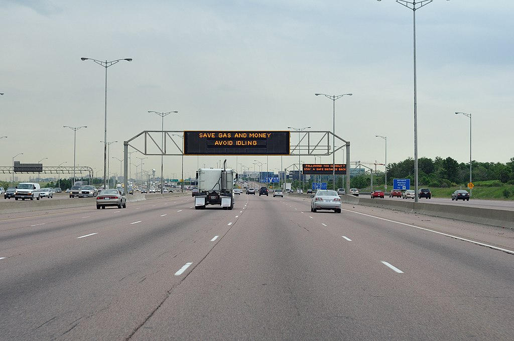
English: Highway 401's widest point: 18 lanes wide near Pearson Airport in Toronto, Ontario, Canada. |
| ရက်စွဲ | Taken on ၁၁ ဇွန် ၂၀၀၉ |
| ရင်းမြစ် | Truvelo |
| စာရေးသူ | James Bancroft (Truvelo) |
| ခွင့်ပြုချက် (ဤဖိုင်ကို ပြန်လည်အသုံးပြုခြင်း) |
Given by creator to use on Wikipedia. |
လိုင်စင်သတ်မှတ်ခြင်း
ဤဖိုင်သည် Creative Commons Attribution 1.0 Generic လိုင်စင်အောက်တွင် လိုင်စင်သတ်မှတ်ထားပါသည်။
မှတ်ယူနိုင်ခြင်း: James Bancroft
- သင်သည် လွတ်လပ်စွာ:
- မျှဝေရန် – ဖန်တီးမှုကို ကူးယူရန်၊ ဖြန့်ဖြူးရန်နှင့် ထုတ်လွှင့်ရန်
- ပြန်ရောနှောရန် – ဖန်တီးမှုကို ပြင်ဆင်ညှိနှိုင်းရန်
- အောက်ပါ အခြေအနေများတွင်:
- မှတ်ယူနိုင်ခြင်း – ပြောင်းလဲမှုများ ပြုလုပ်ခဲ့ပါက ဖန်တီးသူ သို့မဟုတ် လိုင်စင်ရှိသူမှ သတ်မှတ်သော အမျိုးအစားကို လိုက်နာရမည် (ဆိုလိုသည်မှာ သင့်အား သို့မဟုတ် သင့်ဖန်တီးမှုတွင် အသုံးပြုခြင်းအား ထောက်ခံချက်ပေးသည်ဟု မဆိုလိုပါ)။
ဖိုင်မှတ်တမ်း
ဖိုင်ကို ယင်းနေ့စွဲ အတိုင်း မြင်နိုင်ရန် နေ့စွဲ/အချိန် တစ်ခုခုပေါ်တွင် ကလစ်နှိပ်ပါ။
| နေ့စွဲ/အချိန် | နမူနာပုံငယ် | မှတ်တမ်း ဒိုင်မန်းရှင်းများ | အသုံးပြုသူ | မှတ်ချက် | |
|---|---|---|---|---|---|
| ကာလပေါ် | ၀၄:၂၄၊ ၃၀ မေ ၂၀၁၀ | | ၄၂၈၈ × ၂၈၄၈ (၁.၃၇ MB) | Haljackey | Revert to original for now. |
| ၀၃:၅၃၊ ၁၁ မေ ၂၀၁၀ |  | ၄၂၈၇ × ၂၃၈၈ (၅.၉၉ MB) | Haljackey | This one just has the sky cropped. Looks better with the extra pavement at the bottom. This version is also slightly cleaner looking than the previous versions. | |
| ၂၁:၄၉၊ ၁၀ မေ ၂၀၁၀ | ၄၂၈၇ × ၁၄၂၉ (၁.၆၁ MB) | Haljackey | Less sky and pavement. | ||
| ၂၃:၃၇၊ ၂၁ ဧပြီ ၂၀၁၀ |  | ၄၂၈၈ × ၂၈၄၈ (၁.၃၇ MB) | Haljackey | {{Information |Description={{en|1=Highway 401's widest point: 18 lanes wide near Pearson Airport.}} |Source=Truvelo |Author=Truvelo |Date=2009-06-13 |Permission=Given by creator to use on Wikipedia. |other_versions= }} |
ဖိုင်သုံးစွဲမှု
ဤဖိုင်ကို အသုံးပြုထားသော စာမျက်နှာများမရှိပါ။
ဂလိုဘယ် ဖိုင်သုံးစွဲမှု
အောက်ပါ အခြားဝီကီများတွင် ဤဖိုင်ကို အသုံးပြုထားသည်-
- bn.wikipedia.org တွင် အသုံးပြုမှု
- bs.wikipedia.org တွင် အသုံးပြုမှု
- ca.wikipedia.org တွင် အသုံးပြုမှု
- de.wikipedia.org တွင် အသုံးပြုမှု
- en.wikipedia.org တွင် အသုံးပြုမှု
- es.wikipedia.org တွင် အသုံးပြုမှု
- fi.wikipedia.org တွင် အသုံးပြုမှု
- fr.wikipedia.org တွင် အသုံးပြုမှု
- kn.wikipedia.org တွင် အသုံးပြုမှု
- ur.wikipedia.org တွင် အသုံးပြုမှု
- vi.wikipedia.org တွင် အသုံးပြုမှု