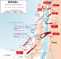
ဖိုင်:1948 Arab Israeli War - May 15-June 10.svg

Size of this PNG preview of this SVG file: ၆၁၃ × ၅၉၉ ပစ်ဇယ်. အခြား ပုံရိပ်ပြတ်သားမှု: ၂၄၅ × ၂၄၀ ပစ်ဇယ် | ၄၉၁ × ၄၈၀ ပစ်ဇယ် | ၇၈၅ × ၇၆၈ ပစ်ဇယ် | ၁၀၄၇ × ၁၀၂၄ ပစ်ဇယ် | ၂၀၉၄ × ၂၀၄၈ ပစ်ဇယ် | ၉၀၄ × ၈၈၄ ပစ်ဇယ်။
မူရင်းဖိုင် (SVG ဖိုင်, ၉၀၄ × ၈၈၄ pixels ကို အကြံပြုသည်, ဖိုင်အရွယ်အစား - ၄၅၄ KB)
ဖိုင်မှတ်တမ်း
ဖိုင်ကို ယင်းနေ့စွဲ အတိုင်း မြင်နိုင်ရန် နေ့စွဲ/အချိန် တစ်ခုခုပေါ်တွင် ကလစ်နှိပ်ပါ။
| နေ့စွဲ/အချိန် | နမူနာပုံငယ် | မှတ်တမ်း ဒိုင်မန်းရှင်းများ | အသုံးပြုသူ | မှတ်ချက် | |
|---|---|---|---|---|---|
| ကာလပေါ် | ၀၃:၃၄၊ ၁၂ အောက်တိုဘာ ၂၀၂၃ |  | ၉၀၄ × ၈၈၄ (၄၅၄ KB) | Shiro D. Neko | File uploaded using svgtranslate tool (https://svgtranslate.toolforge.org/). Added translation for uk. |
| ၁၅:၃၀၊ ၂၀ နိုဝင်ဘာ ၂၀၀၉ |  | ၉၀၄ × ၈၈၄ (၄၁၀ KB) | Honza.havlicek | {{Information |Description={{en|1=Map depicting military operations from 15th May 1948 to 10th June 1948 during {{w|1948_Arab–Israeli_War|Israeli War of Independence}}. Symbols used in the map are {{w|NATO_map_symbols|NATO military symbols}}.}} |Source= |
ဖိုင်သုံးစွဲမှု
ဤဖိုင်ကို အသုံးပြုထားသော စာမျက်နှာများမရှိပါ။
ဂလိုဘယ် ဖိုင်သုံးစွဲမှု
အောက်ပါ အခြားဝီကီများတွင် ဤဖိုင်ကို အသုံးပြုထားသည်-
- ar.wikipedia.org တွင် အသုံးပြုမှု
- arz.wikipedia.org တွင် အသုံးပြုမှု
- ast.wikipedia.org တွင် အသုံးပြုမှု
- azb.wikipedia.org တွင် အသုံးပြုမှု
- ca.wikipedia.org တွင် အသုံးပြုမှု
- ckb.wikipedia.org တွင် အသုံးပြုမှု
- cs.wikipedia.org တွင် အသုံးပြုမှု
- da.wikipedia.org တွင် အသုံးပြုမှု
- de.wikipedia.org တွင် အသုံးပြုမှု
- en.wikipedia.org တွင် အသုံးပြုမှု
- eo.wikipedia.org တွင် အသုံးပြုမှု
- fi.wikipedia.org တွင် အသုံးပြုမှု
- gl.wikipedia.org တွင် အသုံးပြုမှု
- ha.wikipedia.org တွင် အသုံးပြုမှု
- he.wikipedia.org တွင် အသုံးပြုမှု
- hy.wikipedia.org တွင် အသုံးပြုမှု
- id.wikipedia.org တွင် အသုံးပြုမှု
- it.wikipedia.org တွင် အသုံးပြုမှု
- ja.wikipedia.org တွင် အသုံးပြုမှု
- ko.wikipedia.org တွင် အသုံးပြုမှု
- lv.wikipedia.org တွင် အသုံးပြုမှု
- min.wikipedia.org တွင် အသုံးပြုမှု
- ms.wikipedia.org တွင် အသုံးပြုမှု
- nl.wikipedia.org တွင် အသုံးပြုမှု
- nn.wikipedia.org တွင် အသုံးပြုမှု
- no.wikipedia.org တွင် အသုံးပြုမှု
- pl.wikipedia.org တွင် အသုံးပြုမှု
- pnb.wikipedia.org တွင် အသုံးပြုမှု
- pt.wikipedia.org တွင် အသုံးပြုမှု
- ro.wikipedia.org တွင် အသုံးပြုမှု
ဤဖိုင်ကို အခြားနေရာများတွင် အသုံးပြုထားမှုများအား ကြည့်ရှုရန်။


