
ဖိုင်:1870 Index Chart to GTS India-1.jpg
ဤနမူနာ၏ အရွယ်အစား - ၆၂၅ × ၅၉၉ ပစ်ဇယ်။ အခြား ပုံရိပ်ပြတ်သားမှု: ၂၅၀ × ၂၄၀ ပစ်ဇယ် | ၅၀၁ × ၄၈၀ ပစ်ဇယ် | ၈၀၁ × ၇၆၈ ပစ်ဇယ် | ၁၀၆၈ × ၁၀၂၄ ပစ်ဇယ် | ၂၁၃၆ × ၂၀၄၈ ပစ်ဇယ် | ၇၃၀၈ × ၇၀၀၆ ပစ်ဇယ်။
မူရင်းဖိုင် (၇၃၀၈ × ၇၀၀၆ pixels, ဖိုင်အရွယ်အစား - ၂၅.၅၅ MB, MIME အမျိုးအစား image/jpeg)
| ဤဖိုင်သည် Wikimedia Commons မှဖြစ်ပြီး အခြားပရောဂျက်များတွင် သုံးကောင်းသုံးလိမ့်မည်။ ယင်း၏ ဖိုင်အကြောင်းစာမျက်နှာ တွင် ဖော်ပြထားချက်ကို အောက်တွင် ပြထားသည်။ Commons သည် မူပိုင်ခွင့်လွတ်လပ်သော မီဒီယာဖိုင်များ သိုလှောင်ထားရာ နေရာ ဖြစ်သည်။ သင်လည်း ပါဝင်ကူညီနိုင်ပါသည်။ |
အကျဉ်းချုပ်
လိုင်စင်သတ်မှတ်ခြင်း
This media file is in the public domain in the United States. This applies to U.S. works where the copyright has expired, often because its first publication occurred prior to January 1, 1929, and if not then due to lack of notice or renewal. See this page for further explanation.
|
 | |
 |
This image might not be in the public domain outside of the United States; this especially applies in the countries and areas that do not apply the rule of the shorter term for US works, such as Canada, Mainland China (not Hong Kong or Macao), Germany, Mexico, and Switzerland. The creator and year of publication are essential information and must be provided. See Wikipedia:Public domain and Wikipedia:Copyrights for more details.
|
ဖိုင်မှတ်တမ်း
ဖိုင်ကို ယင်းနေ့စွဲ အတိုင်း မြင်နိုင်ရန် နေ့စွဲ/အချိန် တစ်ခုခုပေါ်တွင် ကလစ်နှိပ်ပါ။
| နေ့စွဲ/အချိန် | နမူနာပုံငယ် | မှတ်တမ်း ဒိုင်မန်းရှင်းများ | အသုံးပြုသူ | မှတ်ချက် | |
|---|---|---|---|---|---|
| ကာလပေါ် | ၁၂:၃၇၊ ၆ ဩဂုတ် ၂၀၁၄ | | ၇၃၀၈ × ၇၀၀၆ (၂၅.၅၅ MB) | Shyamal | clean |
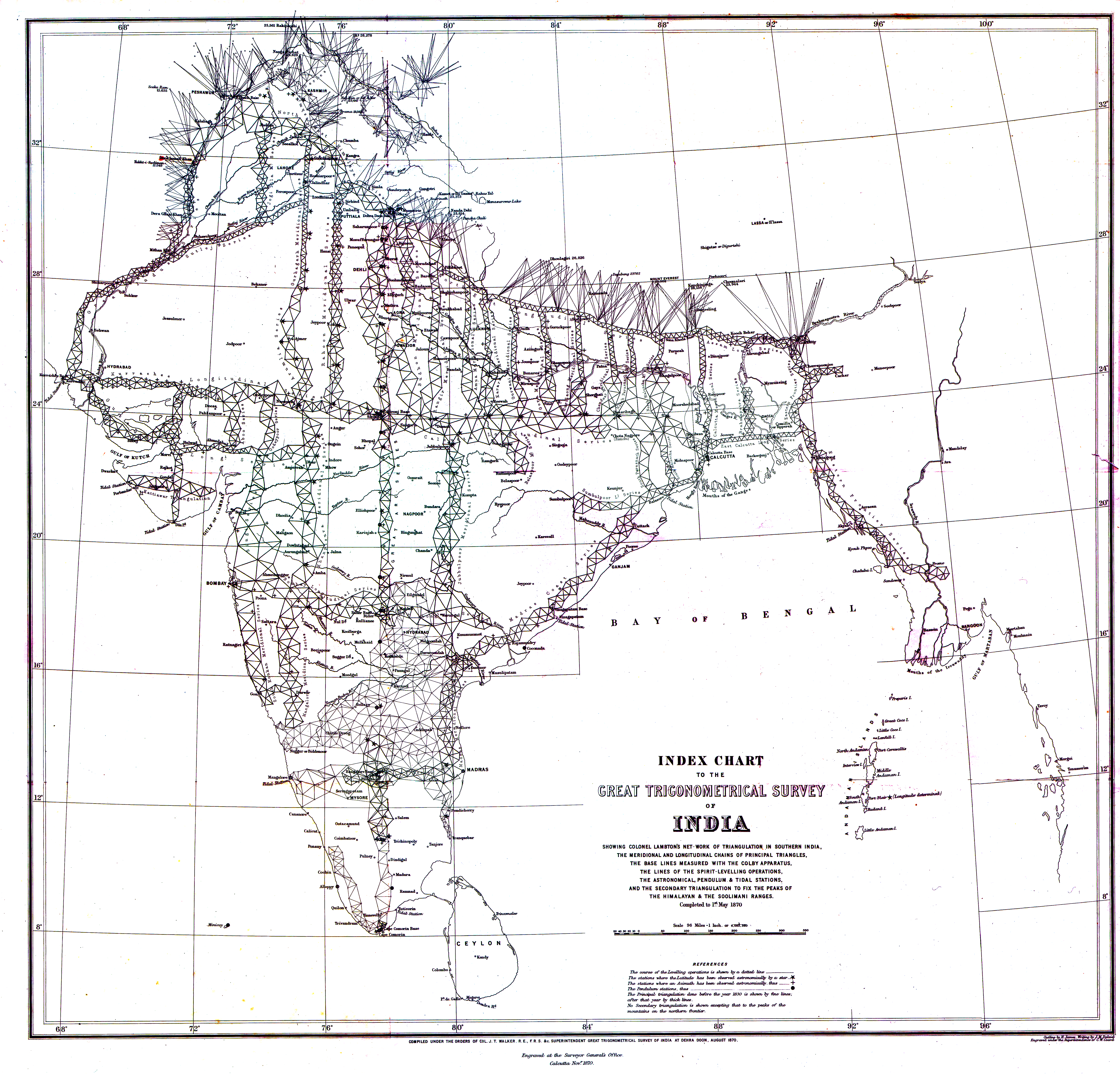
| ၀၀:၂၂၊ ၅ စက်တင်ဘာ ၂၀၁၃ |  | ၇၃၀၈ × ၇၀၀၆ (၃.၅၂ MB) | SanderO | {{Information |Description ={{en|1=1870 Index Chart of the Great Trigonometric Survey of India}} {{nl|1=1870 kaart van de Grote Trigonometrische Kartering van India}} |Source =Survey of India |Author =Survey of India |Date ... |
ဖိုင်သုံးစွဲမှု
ဤဖိုင်ကို အသုံးပြုထားသော စာမျက်နှာများမရှိပါ။
ဂလိုဘယ် ဖိုင်သုံးစွဲမှု
အောက်ပါ အခြားဝီကီများတွင် ဤဖိုင်ကို အသုံးပြုထားသည်-
- bg.wikipedia.org တွင် အသုံးပြုမှု
- ca.wikipedia.org တွင် အသုံးပြုမှု
- da.wikipedia.org တွင် အသုံးပြုမှု
- de.wikipedia.org တွင် အသုံးပြုမှု
- el.wikipedia.org တွင် အသုံးပြုမှု
- en.wikipedia.org တွင် အသုံးပြုမှု
- es.wikipedia.org တွင် အသုံးပြုမှု
- eu.wikipedia.org တွင် အသုံးပြုမှု
- hi.wikipedia.org တွင် အသုံးပြုမှု
- id.wikipedia.org တွင် အသုံးပြုမှု
- it.wikipedia.org တွင် အသုံးပြုမှု
- ja.wikipedia.org တွင် အသုံးပြုမှု
- kn.wikipedia.org တွင် အသုံးပြုမှု
- la.wikipedia.org တွင် အသုံးပြုမှု
- mk.wikipedia.org တွင် အသုံးပြုမှု
- mt.wikipedia.org တွင် အသုံးပြုမှု
- nl.wikipedia.org တွင် အသုံးပြုမှု
- pt.wikipedia.org တွင် အသုံးပြုမှု
- ro.wikipedia.org တွင် အသုံးပြုမှု
- ru.wikipedia.org တွင် အသုံးပြုမှု
- sr.wikipedia.org တွင် အသုံးပြုမှု
- te.wikipedia.org တွင် အသုံးပြုမှု
- uk.wikipedia.org တွင် အသုံးပြုမှု
- www.wikidata.org တွင် အသုံးပြုမှု
- zh.wikipedia.org တွင် အသုံးပြုမှု