
ဖိုင်:1840–42 Royal Engineers map of Jaffa.jpg
မူရင်းဖိုင် (၂၀၅၉ × ၁၉၅၅ pixels, ဖိုင်အရွယ်အစား - ၉၆၁ KB, MIME အမျိုးအစား image/jpeg)
| ဤဖိုင်သည် Wikimedia Commons မှဖြစ်ပြီး အခြားပရောဂျက်များတွင် သုံးကောင်းသုံးလိမ့်မည်။ ယင်း၏ ဖိုင်အကြောင်းစာမျက်နှာ တွင် ဖော်ပြထားချက်ကို အောက်တွင် ပြထားသည်။ Commons သည် မူပိုင်ခွင့်လွတ်လပ်သော မီဒီယာဖိုင်များ သိုလှောင်ထားရာ နေရာ ဖြစ်သည်။ သင်လည်း ပါဝင်ကူညီနိုင်ပါသည်။ |
အကျဉ်းချုပ်
| ဖော်ပြချက် |
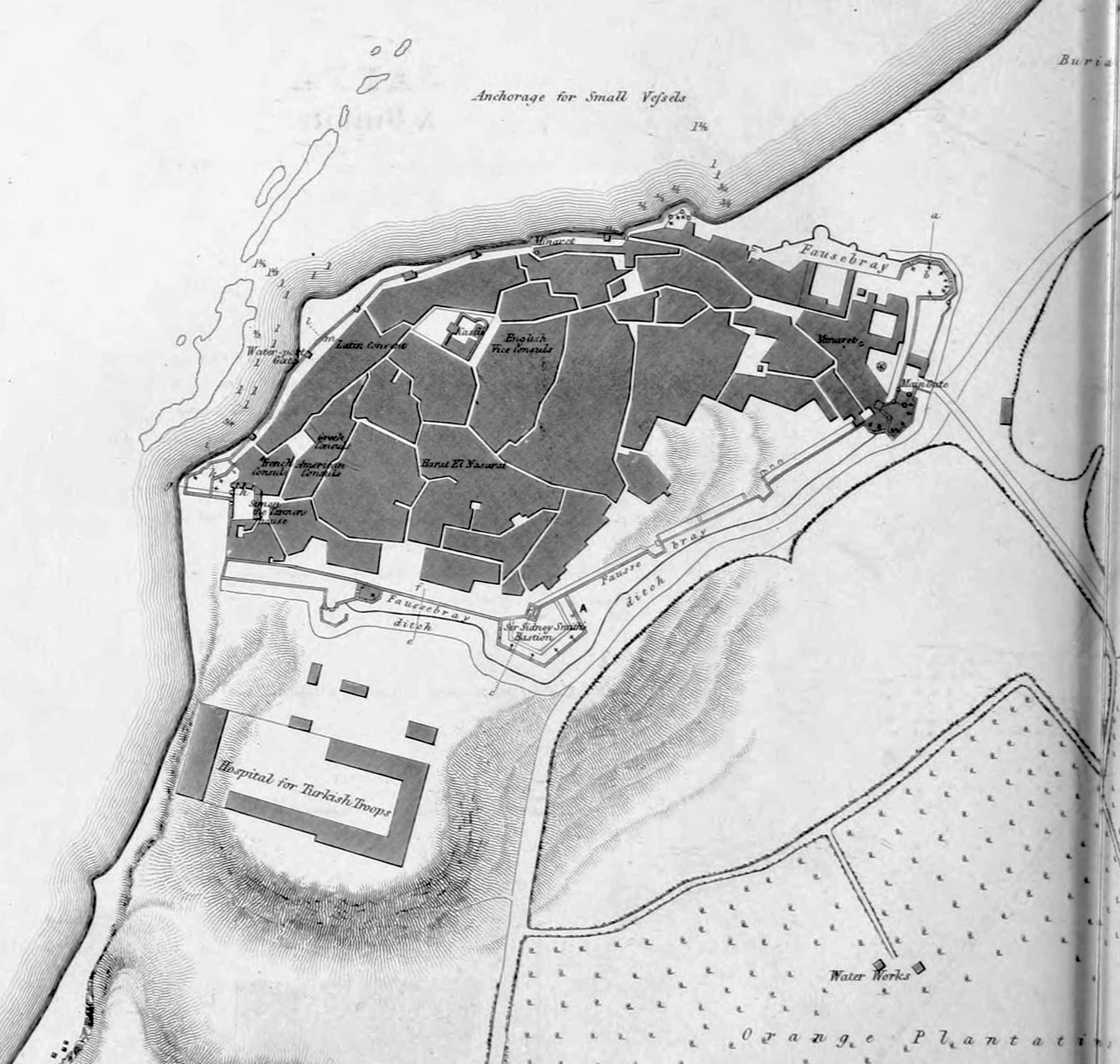
English: 1840–41 Royal Engineers map of Jaffa |
| ရက်စွဲ | |
| ရင်းမြစ် |
https://archive.org/details/papersonsubjects06grea/page/n97 Papers on subjects connected with the duties of the Corps Volume 6 1843 Chapter 3: Notes on Acre and some of the Coast Defences of Syria by Ralph Carr Alderson Pages 19-62 |
| စာရေးသူ | UK Government - Royal Engineers Corps |
လိုင်စင်သတ်မှတ်ခြင်း
|
ဤဖန်တီးမှုလက်ရာအား ၎င်း၏ မူရင်းနိုင်ငံနှင့် အခြားနိုင်ငံဒေသများတွင် အများပြည်သူပိုင်အဖြစ် သတ်မှတ်ထားရာ၌ မူပိုင်ခွင့်သက်တမ်းအပေါ် အဓိပ္ပါယ်ဖွင့်ဆိုထားသည်မှာ ၎င်းအား ဖန်တီးခဲ့သူ ပုဂ္ဂိုလ်၏ သက်တမ်းအား (70) နှစ်ဖြင့် ပေါင်းခြင်းရလဒ် (သို့) ၎င်းထက်ပို၍နည်းသော ဖွင့်ဆိုချက် ဟု ဆိုလိုခြင်းဖြစ်သည်။
| |
| This file has been identified as being free of known restrictions under copyright law, including all related and neighboring rights. | |
This media file is in the public domain in the United States. This applies to U.S. works where the copyright has expired, often because its first publication occurred prior to January 1, 1929, and if not then due to lack of notice or renewal. See this page for further explanation.
|
 | |
 |
This image might not be in the public domain outside of the United States; this especially applies in the countries and areas that do not apply the rule of the shorter term for US works, such as Canada, Mainland China (not Hong Kong or Macao), Germany, Mexico, and Switzerland. The creator and year of publication are essential information and must be provided. See Wikipedia:Public domain and Wikipedia:Copyrights for more details.
|
ဖိုင်မှတ်တမ်း
ဖိုင်ကို ယင်းနေ့စွဲ အတိုင်း မြင်နိုင်ရန် နေ့စွဲ/အချိန် တစ်ခုခုပေါ်တွင် ကလစ်နှိပ်ပါ။
| နေ့စွဲ/အချိန် | နမူနာပုံငယ် | မှတ်တမ်း ဒိုင်မန်းရှင်းများ | အသုံးပြုသူ | မှတ်ချက် | |
|---|---|---|---|---|---|
| ကာလပေါ် | ၀၁:၁၅၊ ၂၉ ဒီဇင်ဘာ ၂၀၁၉ | | ၂၀၅၉ × ၁၉၅၅ (၉၆၁ KB) | Onceinawhile | zoomed in, whiten |
| ၀၀:၅၅၊ ၂၉ ဒီဇင်ဘာ ၂၀၁၉ |  | ၂၃၂၉ × ၃၀၉၁ (၄၇၅ KB) | Onceinawhile | User created page with UploadWizard |
ဖိုင်သုံးစွဲမှု
ဤဖိုင်ကို အသုံးပြုထားသော စာမျက်နှာများမရှိပါ။
ဂလိုဘယ် ဖိုင်သုံးစွဲမှု
အောက်ပါ အခြားဝီကီများတွင် ဤဖိုင်ကို အသုံးပြုထားသည်-
- ar.wikipedia.org တွင် အသုံးပြုမှု
- en.wikipedia.org တွင် အသုံးပြုမှု
- es.wikipedia.org တွင် အသုံးပြုမှု
- fa.wikipedia.org တွင် အသုံးပြုမှု
- fi.wikipedia.org တွင် အသုံးပြုမှု
- he.wikipedia.org တွင် အသုံးပြုမှု
- no.wikipedia.org တွင် အသုံးပြုမှု
- simple.wikipedia.org တွင် အသုံးပြုမှု
- uz.wikipedia.org တွင် အသုံးပြုမှု