
ဖိုင်:1835 S.D.U.K. City Map or Plan of Florence or Firenze, Italy - Geographicus - Florence-SDUK-1835.jpg
မူရင်းဖိုင် (၂၅၀၀ × ၁၈၄၈ pixels, ဖိုင်အရွယ်အစား - ၁ MB, MIME အမျိုးအစား image/jpeg)
| ဤဖိုင်သည် Wikimedia Commons မှဖြစ်ပြီး အခြားပရောဂျက်များတွင် သုံးကောင်းသုံးလိမ့်မည်။ ယင်း၏ ဖိုင်အကြောင်းစာမျက်နှာ တွင် ဖော်ပြထားချက်ကို အောက်တွင် ပြထားသည်။ Commons သည် မူပိုင်ခွင့်လွတ်လပ်သော မီဒီယာဖိုင်များ သိုလှောင်ထားရာ နေရာ ဖြစ်သည်။ သင်လည်း ပါဝင်ကူညီနိုင်ပါသည်။ |
| William Barnard Clarke: Florence. Firenze.
( |
||||||||||||||||||||
|---|---|---|---|---|---|---|---|---|---|---|---|---|---|---|---|---|---|---|---|---|
| အနုပညာရှင် | ||||||||||||||||||||
| စာရေးသူ |
|
|||||||||||||||||||
| ခေါင်းစဉ် |
Florence. Firenze. |
|||||||||||||||||||
| ဖော်ပြချက် |
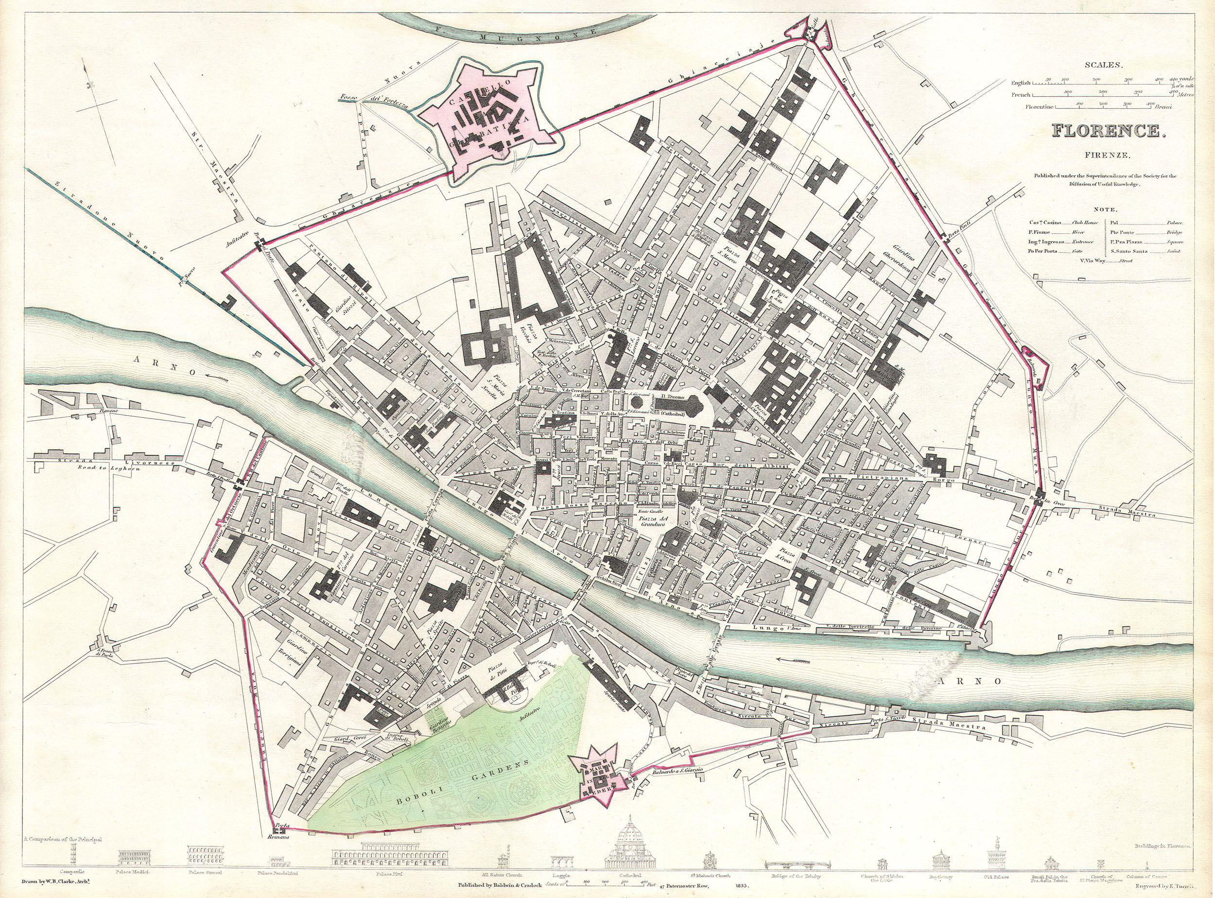
English: This map is a steel plate engraving, dating to 1835 by the Society for the Diffusion of Useful Knowledge, S.D.U.K. It represents the city of Florence or Firenze, Italy. Depicts the old city of Firenze in considerable detail and give attention to most important streets, buildings and monuments. Along the bottom of the map there appears drawings of the facades of 16 Florentine structures entitled A comparison of the principal buildings in Florence. Published for the Society for the Diffusion of Useful Knowledge, by Baldwin and Cradock of Paternoster Row, London, 1835. |
|||||||||||||||||||
| ရက်စွဲ | ၁၈၃၅ | |||||||||||||||||||
| ရှုထောင့်များ | height: ၁၂.၀ in (၃၀.၄ cm); width: ၁၅.၀ in (၃၈.၁ cm) | |||||||||||||||||||
| Accession number |
Geographicus link: Florence-SDUK-1835 |
|||||||||||||||||||
| Source/Photographer |
Maps of the Society for the Diffusion of Useful Knowledge. Vol1. 1844.
|
|||||||||||||||||||
| ခွင့်ပြုချက် (ဤဖိုင်ကို ပြန်လည်အသုံးပြုခြင်း) |
|
|||||||||||||||||||
ဖိုင်မှတ်တမ်း
ဖိုင်ကို ယင်းနေ့စွဲ အတိုင်း မြင်နိုင်ရန် နေ့စွဲ/အချိန် တစ်ခုခုပေါ်တွင် ကလစ်နှိပ်ပါ။
| နေ့စွဲ/အချိန် | နမူနာပုံငယ် | မှတ်တမ်း ဒိုင်မန်းရှင်းများ | အသုံးပြုသူ | မှတ်ချက် | |
|---|---|---|---|---|---|
| ကာလပေါ် | ၁၈:၅၂၊ ၂၄ မတ် ၂၀၁၁ | | ၂၅၀၀ × ၁၈၄၈ (၁ MB) | BotMultichillT | {{subst:User:Multichill/Geographicus |link=http://www.geographicus.com/P/AntiqueMap/Florence-SDUK-1835 |product_name=1835 S.D.U.K. City Map or Plan of Florence or Firenze, Italy |map_title=Florence. Firenze. |description=This map is a steel plate engravin |
ဖိုင်သုံးစွဲမှု
အောက်ပါ စာမျက်နှာ သည် ဤဖိုင်ကို အသုံးပြုထားသည်:
ဂလိုဘယ် ဖိုင်သုံးစွဲမှု
အောက်ပါ အခြားဝီကီများတွင် ဤဖိုင်ကို အသုံးပြုထားသည်-
- de.wikipedia.org တွင် အသုံးပြုမှု
- en.wikipedia.org တွင် အသုံးပြုမှု
- gl.wikipedia.org တွင် အသုံးပြုမှု
- ha.wikipedia.org တွင် အသုံးပြုမှု
- ko.wikipedia.org တွင် အသုံးပြုမှု
- mk.wikipedia.org တွင် အသုံးပြုမှု
- ro.wikipedia.org တွင် အသုံးပြုမှု
- sl.wikipedia.org တွင် အသုံးပြုမှု
- tr.wikipedia.org တွင် အသုံးပြုမှု
- vi.wikipedia.org တွင် အသုံးပြုမှု