
ဖိုင်:Willandra Lakes.png

ဤနမူနာ၏ အရွယ်အစား - ၄၈၂ × ၆၀၀ ပစ်ဇယ်။ အခြား ပုံရိပ်ပြတ်သားမှု: ၁၉၃ × ၂၄၀ ပစ်ဇယ် | ၅၆၀ × ၆၉၇ ပစ်ဇယ်။
မူရင်းဖိုင် (၅၆၀ × ၆၉၇ pixels, ဖိုင်အရွယ်အစား - ၈၈၇ KB, MIME အမျိုးအစား image/png)
| ဤဖိုင်သည် Wikimedia Commons မှဖြစ်ပြီး အခြားပရောဂျက်များတွင် သုံးကောင်းသုံးလိမ့်မည်။ ယင်း၏ ဖိုင်အကြောင်းစာမျက်နှာ တွင် ဖော်ပြထားချက်ကို အောက်တွင် ပြထားသည်။ Commons သည် မူပိုင်ခွင့်လွတ်လပ်သော မီဒီယာဖိုင်များ သိုလှောင်ထားရာ နေရာ ဖြစ်သည်။ သင်လည်း ပါဝင်ကူညီနိုင်ပါသည်။ |
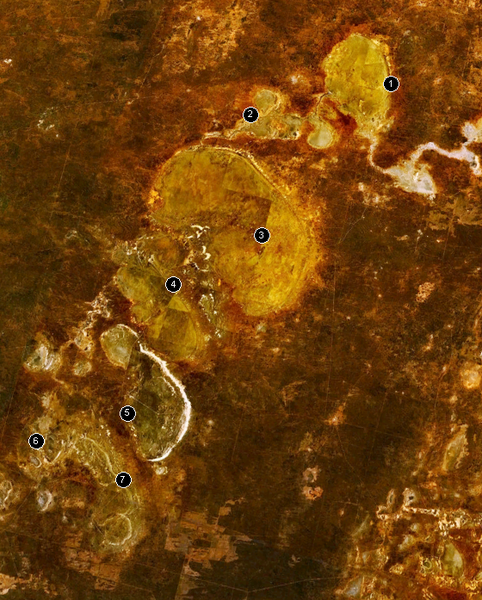
The w:Willandra Lakes Region in Australia.
- Lake Mulurulu
- Willandra Creek
- Garnpung Lake
- Lake Leaghur
- Lake Mungo
- Lake Arumpo
- Chibnalwood Lakes
| This image is in the public domain because it is a screenshot from NASA’s globe software World Wind using a public domain layer, such as Blue Marble, MODIS, Landsat, SRTM, USGS or GLOBE.
|
 |
ဖိုင်မှတ်တမ်း
ဖိုင်ကို ယင်းနေ့စွဲ အတိုင်း မြင်နိုင်ရန် နေ့စွဲ/အချိန် တစ်ခုခုပေါ်တွင် ကလစ်နှိပ်ပါ။
| နေ့စွဲ/အချိန် | နမူနာပုံငယ် | မှတ်တမ်း ဒိုင်မန်းရှင်းများ | အသုံးပြုသူ | မှတ်ချက် | |
|---|---|---|---|---|---|
| ကာလပေါ် | ၁၃:၀၈၊ ၂၈ ဒီဇင်ဘာ ၂၀၀၅ | | ၅၆၀ × ၆၉၇ (၈၈၇ KB) | Stephen Bain | The w:Willandra Lakes Region in Australia. # Lake Mulurulu # Willandra Creek # Garnpung Lake # Lake Leaghur # Lake Mungo # Lake Arumpo # Chibnalwood Lakes {{PD-WorldWind}} |
ဖိုင်သုံးစွဲမှု
အောက်ပါ စာမျက်နှာ သည် ဤဖိုင်ကို အသုံးပြုထားသည်:
ဂလိုဘယ် ဖိုင်သုံးစွဲမှု
အောက်ပါ အခြားဝီကီများတွင် ဤဖိုင်ကို အသုံးပြုထားသည်-
- ast.wikipedia.org တွင် အသုံးပြုမှု
- be.wikipedia.org တွင် အသုံးပြုမှု
- ca.wikipedia.org တွင် အသုံးပြုမှု
- cs.wikipedia.org တွင် အသုံးပြုမှု
- de.wikipedia.org တွင် အသုံးပြုမှု
- de.wikivoyage.org တွင် အသုံးပြုမှု
- en.wikipedia.org တွင် အသုံးပြုမှု
- en.wikibooks.org တွင် အသုံးပြုမှု
- en.wikivoyage.org တွင် အသုံးပြုမှု
- es.wikipedia.org တွင် အသုံးပြုမှု
- fa.wikipedia.org တွင် အသုံးပြုမှု
- fi.wikipedia.org တွင် အသုံးပြုမှု
- fr.wikipedia.org တွင် အသုံးပြုမှု
- he.wikipedia.org တွင် အသုံးပြုမှု
- he.wikivoyage.org တွင် အသုံးပြုမှု
- hr.wikipedia.org တွင် အသုံးပြုမှု
- hu.wikipedia.org တွင် အသုံးပြုမှု
- it.wikipedia.org တွင် အသုံးပြုမှု
- it.wikivoyage.org တွင် အသုံးပြုမှု
- ja.wikipedia.org တွင် အသုံးပြုမှု
- ja.wikivoyage.org တွင် အသုံးပြုမှု
- lt.wikipedia.org တွင် အသုံးပြုမှု
- mt.wikipedia.org တွင် အသုံးပြုမှု
- ne.wikipedia.org တွင် အသုံးပြုမှု
- nl.wikipedia.org တွင် အသုံးပြုမှု
- no.wikipedia.org တွင် အသုံးပြုမှု
- pl.wikipedia.org တွင် အသုံးပြုမှု
- pt.wikipedia.org တွင် အသုံးပြုမှု
- ro.wikipedia.org တွင် အသုံးပြုမှု
- ru.wikipedia.org တွင် အသုံးပြုမှု
- sh.wikipedia.org တွင် အသုံးပြုမှု
- simple.wikipedia.org တွင် အသုံးပြုမှု
- sk.wikipedia.org တွင် အသုံးပြုမှု
- sv.wikipedia.org တွင် အသုံးပြုမှု
- ta.wikipedia.org တွင် အသုံးပြုမှု
ဤဖိုင်ကို အခြားနေရာများတွင် အသုံးပြုထားမှုများအား ကြည့်ရှုရန်။