
ဖိုင်:Wfm area 51 landsat geocover 2000.jpg
ဤနမူနာ၏ အရွယ်အစား - ၄၇၅ × ၅၉၉ ပစ်ဇယ်။ အခြား ပုံရိပ်ပြတ်သားမှု: ၁၉၀ × ၂၄၀ ပစ်ဇယ် | ၃၈၁ × ၄၈၀ ပစ်ဇယ် | ၇၅၂ × ၉၄၈ ပစ်ဇယ်။
မူရင်းဖိုင် (၇၅၂ × ၉၄၈ pixels, ဖိုင်အရွယ်အစား - ၃၈၃ KB, MIME အမျိုးအစား image/jpeg)
| ဤဖိုင်သည် Wikimedia Commons မှဖြစ်ပြီး အခြားပရောဂျက်များတွင် သုံးကောင်းသုံးလိမ့်မည်။ ယင်း၏ ဖိုင်အကြောင်းစာမျက်နှာ တွင် ဖော်ပြထားချက်ကို အောက်တွင် ပြထားသည်။ Commons သည် မူပိုင်ခွင့်လွတ်လပ်သော မီဒီယာဖိုင်များ သိုလှောင်ထားရာ နေရာ ဖြစ်သည်။ သင်လည်း ပါဝင်ကူညီနိုင်ပါသည်။ |
| ဖော်ပြချက် |
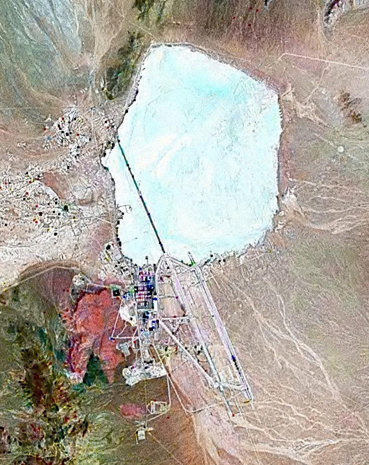
English: Landsat GeoCover 2000 pseudocolour imagery of Area 51 at Groom Lake, Nevada Test and Training Range, Nevada, USA
|
||||
| ရက်စွဲ | circa ၂၀၀၀ | ||||
| ရင်းမြစ် | NASA Landsat | ||||
| စာရေးသူ | NASA | ||||
| ခွင့်ပြုချက် (ဤဖိုင်ကို ပြန်လည်အသုံးပြုခြင်း) |
|

ဖိုင်မှတ်တမ်း
ဖိုင်ကို ယင်းနေ့စွဲ အတိုင်း မြင်နိုင်ရန် နေ့စွဲ/အချိန် တစ်ခုခုပေါ်တွင် ကလစ်နှိပ်ပါ။
| နေ့စွဲ/အချိန် | နမူနာပုံငယ် | မှတ်တမ်း ဒိုင်မန်းရှင်းများ | အသုံးပြုသူ | မှတ်ချက် | |
|---|---|---|---|---|---|
| ကာလပေါ် | ၁၂:၄၂၊ ၁၈ ဖေဖော်ဝါရီ ၂၀၁၀ | | ၇၅၂ × ၉၄၈ (၃၈၃ KB) | Finlay McWalter | rv, that's not a landsat image; it looks very much like a copyright GeoEye/Google Earth image, which is inelligible for use on Commons. If you diagree, upload the image under another name, don't contaminate this one with false information |
| ၁၁:၀၅၊ ၇ ဖေဖော်ဝါရီ ၂၀၁၀ |  | ၄၅၆ × ၆၁၇ (၄၅ KB) | Vajotwo | Best quality | |
| ၁၂:၅၁၊ ၁၆ ဇူလိုင် ၂၀၀၆ |  | ၇၅၂ × ၉၄၈ (၃၈၃ KB) | Finlay McWalter | {{Information |Description=Landsat geocover 2000 pseudocolour imagery of Area 51 at Groom Lake, Nevada, USA |Source=NASA Landsat |Date=around 2000 |Author=NASA |Permission= {{PD-WorldWind}} |other_versions= }} Category:Area 51 |
ဖိုင်သုံးစွဲမှု
အောက်ပါ စာမျက်နှာ သည် ဤဖိုင်ကို အသုံးပြုထားသည်:
ဂလိုဘယ် ဖိုင်သုံးစွဲမှု
အောက်ပါ အခြားဝီကီများတွင် ဤဖိုင်ကို အသုံးပြုထားသည်-
- ar.wikipedia.org တွင် အသုံးပြုမှု
- az.wikipedia.org တွင် အသုံးပြုမှု
- be.wikipedia.org တွင် အသုံးပြုမှု
- bg.wikipedia.org တွင် အသုံးပြုမှု
- bn.wikipedia.org တွင် အသုံးပြုမှု
- cs.wikipedia.org တွင် အသုံးပြုမှု
- cy.wikipedia.org တွင် အသုံးပြုမှု
- el.wikipedia.org တွင် အသုံးပြုမှု
- en.wikipedia.org တွင် အသုံးပြုမှု
- es.wikipedia.org တွင် အသုံးပြုမှု
- fi.wikipedia.org တွင် အသုံးပြုမှု
- fr.wikipedia.org တွင် အသုံးပြုမှု
- Zone 51
- Wikipédia:Le Bistro/14 février 2009
- Area 51 (jeu vidéo, 2005)
- Wikipédia:Wikimag/2019/28/Rapport de trafic
- Wikipédia:Wikimag/2019/29/Rapport de trafic
- Wikipédia:Wikimag/2019/29
- Wikipédia:Wikimag/2019/30/Rapport de trafic
- Wikipédia:Wikimag/2019/31/Rapport de trafic
- Wikipédia:Wikimag/2019/38
- Wikipédia:Wikimag/2019/39/Rapport de trafic
- gu.wikipedia.org တွင် အသုံးပြုမှု
- he.wikipedia.org တွင် အသုံးပြုမှု
- hi.wikipedia.org တွင် အသုံးပြုမှု
- hr.wikipedia.org တွင် အသုံးပြုမှု
- hu.wikipedia.org တွင် အသုံးပြုမှု
- hy.wikipedia.org တွင် အသုံးပြုမှု
- id.wikipedia.org တွင် အသုံးပြုမှု
- it.wikipedia.org တွင် အသုံးပြုမှု
- kk.wikipedia.org တွင် အသုံးပြုမှု
- kn.wikipedia.org တွင် အသုံးပြုမှု
- mk.wikipedia.org တွင် အသုံးပြုမှု
- pnb.wikipedia.org တွင် အသုံးပြုမှု
- ro.wikipedia.org တွင် အသုံးပြုမှု
- ru.wikipedia.org တွင် အသုံးပြုမှု
- sh.wikipedia.org တွင် အသုံးပြုမှု
- si.wikipedia.org တွင် အသုံးပြုမှု
- sk.wikipedia.org တွင် အသုံးပြုမှု
ဤဖိုင်ကို အခြားနေရာများတွင် အသုံးပြုထားမှုများအား ကြည့်ရှုရန်။