
ဖိုင်:Exclusive Economic Zones - World.svg

Size of this PNG preview of this SVG file: ၈၀၀ × ၄၀၀ ပစ်ဇယ်. အခြား ပုံရိပ်ပြတ်သားမှု: ၃၂၀ × ၁၆၀ ပစ်ဇယ် | ၆၄၀ × ၃၂၀ ပစ်ဇယ် | ၁၀၂၄ × ၅၁၂ ပစ်ဇယ် | ၁၂၈၀ × ၆၄၀ ပစ်ဇယ် | ၂၅၆၀ × ၁၂၈၀ ပစ်ဇယ်။
မူရင်းဖိုင် (SVG ဖိုင်, ၈၀၀ × ၄၀၀ pixels ကို အကြံပြုသည်, ဖိုင်အရွယ်အစား - ၆၉၄ KB)
| ဤဖိုင်သည် Wikimedia Commons မှဖြစ်ပြီး အခြားပရောဂျက်များတွင် သုံးကောင်းသုံးလိမ့်မည်။ ယင်း၏ ဖိုင်အကြောင်းစာမျက်နှာ တွင် ဖော်ပြထားချက်ကို အောက်တွင် ပြထားသည်။ Commons သည် မူပိုင်ခွင့်လွတ်လပ်သော မီဒီယာဖိုင်များ သိုလှောင်ထားရာ နေရာ ဖြစ်သည်။ သင်လည်း ပါဝင်ကူညီနိုင်ပါသည်။ |
အကျဉ်းချုပ်
| ဖော်ပြချက် |
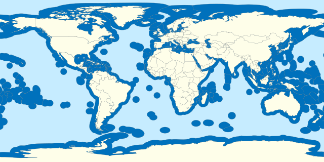
Español: Aguas territoriales del mundo. English: Territorial waters of the world. Français : Z.E.E. de chaque pays du monde. |
| ရက်စွဲ | |
| ရင်းမြစ် |
Own work based on: World location map.svg Borders based on VLIZ Maritime boundaries and Internationalwaters.png |
| စာရေးသူ | B1mbo |
| SVG genesis |
လိုင်စင်သတ်မှတ်ခြင်း
ကျွန်ုပ်၊ ဤလုပ်ဆောင်ချက်၏ မူပိုင်ခွင့်ပိုင်ရှင်အနေဖြင့် ဤနေရာမှ အောက်ပါလိုင်စင်အောက်တွင် ထုတ်လွှင့်ပါသည်:
ဤဖိုင်သည် Creative Commons Attribution-Share Alike 3.0 ချီလီ လိုင်စင်အောက်တွင် လိုင်စင်သတ်မှတ်ထားပါသည်။
- သင်သည် လွတ်လပ်စွာ:
- မျှဝေရန် – ဖန်တီးမှုကို ကူးယူရန်၊ ဖြန့်ဖြူးရန်နှင့် ထုတ်လွှင့်ရန်
- ပြန်ရောနှောရန် – ဖန်တီးမှုကို ပြင်ဆင်ညှိနှိုင်းရန်
- အောက်ပါ အခြေအနေများတွင်:
- မှတ်ယူနိုင်ခြင်း – ပြောင်းလဲမှုများ ပြုလုပ်ခဲ့ပါက ဖန်တီးသူ သို့မဟုတ် လိုင်စင်ရှိသူမှ သတ်မှတ်သော အမျိုးအစားကို လိုက်နာရမည် (ဆိုလိုသည်မှာ သင့်အား သို့မဟုတ် သင့်ဖန်တီးမှုတွင် အသုံးပြုခြင်းအား ထောက်ခံချက်ပေးသည်ဟု မဆိုလိုပါ)။
- ထပ်တူမျှဝေ – ဤဖန်တီးမှုအား ပြင်ဆင်ခြင်း၊ ပြောင်းလဲခြင်း သို့မဟုတ် ထပ်ဆင့် ဖန်တီးခြင်း ပြုလုပ်ပါက ရရှိလာသော ဖန်တီးမှုကို ဤဖန်တီးမှုနှင့် သို့မဟုတ် ဆင်တူသော လိုင်စင်ဖြင့်သာ ဖြန့်ချိသင့်သည်။

ဖိုင်မှတ်တမ်း
ဖိုင်ကို ယင်းနေ့စွဲ အတိုင်း မြင်နိုင်ရန် နေ့စွဲ/အချိန် တစ်ခုခုပေါ်တွင် ကလစ်နှိပ်ပါ။
| နေ့စွဲ/အချိန် | နမူနာပုံငယ် | မှတ်တမ်း ဒိုင်မန်းရှင်းများ | အသုံးပြုသူ | မှတ်ချက် | |
|---|---|---|---|---|---|
| ကာလပေါ် | ၀၉:၂၂၊ ၁၉ အောက်တိုဘာ ၂၀၂၃ | | ၈၀၀ × ၄၀၀ (၆၉၄ KB) | SyntaxTerror | Added Cyprus, many islands are missing (New Caledonia, Socotra, Jeju, Baleares, Caribean islands, islands in Hudson bay, etc.) |
| ၀၀:၃၇၊ ၁ အောက်တိုဘာ ၂၀၂၀ |  | ၈၀၀ × ၄၀၀ (၆၉၂ KB) | The Image Editor | Reverted to version as of 02:36, 12 May 2020 (UTC) The PNG to SVG made the map look really bad | |
| ၂၀:၂၃၊ ၂၉ စက်တင်ဘာ ၂၀၂၀ |  | ၄၀၀ × ၂၀၀ (၁.၅၂ MB) | The Image Editor | Cyprus was missing in the map, so I added it. | |
| ၀၂:၃၆၊ ၁၂ မေ ၂၀၂၀ |  | ၈၀၀ × ၄၀၀ (၆၉၂ KB) | Ratherous | Sea of Okhotsk entirely Russian since 2014 | |
| ၀၀:၁၁၊ ၁၇ ဧပြီ ၂၀၁၅ |  | ၈၀၀ × ၄၀၀ (၆၉၂ KB) | B1mbo | Updating Chile-Peru maritime border | |
| ၂၁:၅၁၊ ၃၁ အောက်တိုဘာ ၂၀၁၁ |  | ၈၀၀ × ၄၀၀ (၆၉၂ KB) | B1mbo | m | |
| ၂၁:၄၉၊ ၃၁ အောက်တိုဘာ ၂၀၁၁ |  | ၈၀၀ × ၄၀၀ (၆၉၀ KB) | B1mbo | mm | |
| ၂၁:၄၆၊ ၃၁ အောက်တိုဘာ ၂၀၁၁ |  | ၈၀၀ × ၄၀၀ (၆၉၁ KB) | B1mbo | m | |
| ၂၁:၃၉၊ ၃၁ အောက်တိုဘာ ၂၀၁၁ |  | ၈၀၀ × ၄၀၀ (၆၉၁ KB) | B1mbo |
ဖိုင်သုံးစွဲမှု
ဤဖိုင်ကို အသုံးပြုထားသော စာမျက်နှာများမရှိပါ။
ဂလိုဘယ် ဖိုင်သုံးစွဲမှု
အောက်ပါ အခြားဝီကီများတွင် ဤဖိုင်ကို အသုံးပြုထားသည်-
- ar.wikipedia.org တွင် အသုံးပြုမှု
- bg.wikipedia.org တွင် အသုံးပြုမှု
- cs.wikipedia.org တွင် အသုံးပြုမှု
- en.wikipedia.org တွင် အသုံးပြုမှု
- es.wikipedia.org တွင် အသုံးပြုမှု
- eu.wikipedia.org တွင် အသုံးပြုမှု
- fa.wikipedia.org တွင် အသုံးပြုမှု
- fi.wikipedia.org တွင် အသုံးပြုမှု
- fr.wikipedia.org တွင် အသုံးပြုမှု
- fr.wikiversity.org တွင် အသုံးပြုမှု
- he.wikipedia.org တွင် အသုံးပြုမှု
- hy.wikipedia.org တွင် အသုံးပြုမှု
- ja.wikipedia.org တွင် အသုံးပြုမှု
- ko.wikipedia.org တွင် အသုံးပြုမှု
- ms.wikipedia.org တွင် အသုံးပြုမှု
- pl.wikipedia.org တွင် အသုံးပြုမှု
- sk.wikipedia.org တွင် အသုံးပြုမှု
- ta.wikipedia.org တွင် အသုံးပြုမှု
- th.wikipedia.org တွင် အသုံးပြုမှု
- tl.wikipedia.org တွင် အသုံးပြုမှု
- tr.wikipedia.org တွင် အသုံးပြုမှု
- vi.wikipedia.org တွင် အသုံးပြုမှု
- www.wikidata.org တွင် အသုံးပြုမှု
- zh.wikipedia.org တွင် အသုံးပြုမှု