
ဖိုင်:Subtes-2015.svg

Size of this PNG preview of this SVG file: ၆၉၄ × ၅၉၉ ပစ်ဇယ်. အခြား ပုံရိပ်ပြတ်သားမှု: ၂၇၈ × ၂၄၀ ပစ်ဇယ် | ၅၅၆ × ၄၈၀ ပစ်ဇယ် | ၈၈၉ × ၇၆၈ ပစ်ဇယ် | ၁၁၈၆ × ၁၀၂၄ ပစ်ဇယ် | ၂၃၇၁ × ၂၀၄၈ ပစ်ဇယ် | ၁၆၅၀ × ၁၄၂၅ ပစ်ဇယ်။
မူရင်းဖိုင် (SVG ဖိုင်, ၁၆၅၀ × ၁၄၂၅ pixels ကို အကြံပြုသည်, ဖိုင်အရွယ်အစား - ၁၄၃ KB)
| ဤဖိုင်သည် Wikimedia Commons မှဖြစ်ပြီး အခြားပရောဂျက်များတွင် သုံးကောင်းသုံးလိမ့်မည်။ ယင်း၏ ဖိုင်အကြောင်းစာမျက်နှာ တွင် ဖော်ပြထားချက်ကို အောက်တွင် ပြထားသည်။ Commons သည် မူပိုင်ခွင့်လွတ်လပ်သော မီဒီယာဖိုင်များ သိုလှောင်ထားရာ နေရာ ဖြစ်သည်။ သင်လည်း ပါဝင်ကူညီနိုင်ပါသည်။ |
| ဖော်ပြချက် |
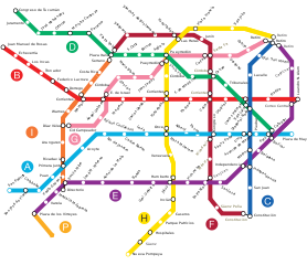
Español: Mapa de la red de subterráneos de la Ciudad de Buenos Aires hacia 2015, con todas las líneas proyectadas según ley 670 de la C.A.B.A.. |
||||||||
| ရင်းမြစ် | Galio, own work. | ||||||||
| စာရေးသူ | Galio | ||||||||
| ခွင့်ပြုချက် (ဤဖိုင်ကို ပြန်လည်အသုံးပြုခြင်း) |
ကျွန်ုပ်၊ ဤလုပ်ဆောင်ချက်၏ မူပိုင်ခွင့်ပိုင်ရှင်အနေဖြင့် ဤနေရာမှ အောက်ပါလိုင်စင်များအောက်တွင် ထုတ်လွှင့်ပါသည်:
ဤဖိုင်သည် Creative Commons Attribution 2.5 Generic လိုင်စင်အောက်တွင် လိုင်စင်သတ်မှတ်ထားပါသည်။
သင်အလိုရှိရာ လိုင်စင်ကို ရွေးချယ်နိုင်ပါသည်။ |

ဖိုင်မှတ်တမ်း
ဖိုင်ကို ယင်းနေ့စွဲ အတိုင်း မြင်နိုင်ရန် နေ့စွဲ/အချိန် တစ်ခုခုပေါ်တွင် ကလစ်နှိပ်ပါ။
| နေ့စွဲ/အချိန် | နမူနာပုံငယ် | မှတ်တမ်း ဒိုင်မန်းရှင်းများ | အသုံးပြုသူ | မှတ်ချက် | |
|---|---|---|---|---|---|
| ကာလပေါ် | ၀၇:၁၆၊ ၁၁ ဇန်နဝါရီ ၂၀၁၆ | | ၁၆၅၀ × ၁၄၂၅ (၁၄၃ KB) | SegataSanshiro1 | Smaller station icons, made interchanges clearer. |
| ၁၉:၃၅၊ ၁ စက်တင်ဘာ ၂၀၁၅ |  | ၁၆၅၀ × ၁၄၂၅ (၁၆၉ KB) | SegataSanshiro1 | Colours changed to match official colours, added Premetro | |
| ၀၅:၃၇၊ ၉ ဇွန် ၂၀၁၃ |  | ၁၆၅၀ × ၁၄၂၅ (၁၅၉ KB) | Galio | la denominación oficial de las estaciones es S. J. de Flores y San Pedrito, "Flores" a secas y Nazca son obsoletos | |
| ၀၃:၃၃၊ ၁၁ ဇွန် ၂၀၁၀ |  | ၁၆၅၀ × ၁၄၂၅ (၁၃၂ KB) | Dexxter | Estaciones proyectadas de Línea A: Flores y Nazca. | |
| ၂၃:၅၂၊ ၈ ဖေဖော်ဝါရီ ၂၀၀၉ |  | ၁၆၅၀ × ၁၄၂၅ (၁၅၉ KB) | Galio | Modificación ubicación Carabobo | |
| ၀၀:၂၀၊ ၂၆ ဩဂုတ် ၂၀၀၈ |  | ၁၆၅၀ × ၁၄၂၅ (၁၅၉ KB) | Ojota | Category:Buenos Aires Metro | |
| ၀၂:၅၇၊ ၁၄ ဇူလိုင် ၂၀၀၈ |  | ၁၆၅၀ × ၁၄၂၅ (၁၅၈ KB) | Galio | {{Information |Description= |Source= |Date= |Author= |Permission= |other_versions= }} | |
| ၀၁:၁၈၊ ၁၄ ဇူလိုင် ၂၀၀၈ |  | ၁၆၅၀ × ၁၄၂၅ (၁၅၉ KB) | Galio | {{Information |Description= |Source= |Date= |Author= |Permission= |other_versions= }} {{ImageUpload|basic}} | |
| ၂၂:၁၅၊ ၁၃ ဇူလိုင် ၂၀၀၈ |  | ၁၆၅၀ × ၁၄၂၅ (၁၅၉ KB) | Galio | {{Information |Description= |Source= |Date= |Author= |Permission= |other_versions= }} | |
| ၀၆:၃၅၊ ၁၃ ဇူလိုင် ၂၀၀၈ |  | ၁၆၅၀ × ၁၄၂၅ (၁၆၁ KB) | Galio | == Sumario == Mapa de la red de subterráneos de la Ciudad de Buenos Aires hacia 2015, con todas las líneas proyectadas según ley 670 de la C.A.B.A. == Licensing == {{self2|GFDL|cc-by-2.5}} Category:Public transport maps of Buenos Aires {{ImageUpl |
ဖိုင်သုံးစွဲမှု
ဤဖိုင်ကို အသုံးပြုထားသော စာမျက်နှာများမရှိပါ။
ဂလိုဘယ် ဖိုင်သုံးစွဲမှု
အောက်ပါ အခြားဝီကီများတွင် ဤဖိုင်ကို အသုံးပြုထားသည်-
- ca.wikipedia.org တွင် အသုံးပြုမှု
- en.wikipedia.org တွင် အသုံးပြုမှု
- es.wikipedia.org တွင် အသုံးပြုမှု
- fr.wikipedia.org တွင် အသုံးပြုမှု
- hy.wikipedia.org တွင် အသုံးပြုမှု
- id.wikipedia.org တွင် အသုံးပြုမှု
- it.wikipedia.org တွင် အသုံးပြုမှု
- ja.wikipedia.org တွင် အသုံးပြုမှု
- nl.wikipedia.org တွင် အသုံးပြုမှု
- ru.wikipedia.org တွင် အသုံးပြုမှု
- th.wikipedia.org တွင် အသုံးပြုမှု
- uk.wikipedia.org တွင် အသုံးပြုမှု