
ဖိုင်:Struthio camelus distribution.svg

Size of this PNG preview of this SVG file: ၅၈၈ × ၆၀၀ ပစ်ဇယ်. အခြား ပုံရိပ်ပြတ်သားမှု: ၂၃၅ × ၂၄၀ ပစ်ဇယ် | ၄၇၀ × ၄၈၀ ပစ်ဇယ် | ၇၅၃ × ၇၆၈ ပစ်ဇယ် | ၁၀၀၄ × ၁၀၂၄ ပစ်ဇယ် | ၂၀၀၇ × ၂၀၄၈ ပစ်ဇယ် | ၆၈၇ × ၇၀၁ ပစ်ဇယ်။
မူရင်းဖိုင် (SVG ဖိုင်, ၆၈၇ × ၇၀၁ pixels ကို အကြံပြုသည်, ဖိုင်အရွယ်အစား - ၇၇၈ KB)
| ဤဖိုင်သည် Wikimedia Commons မှဖြစ်ပြီး အခြားပရောဂျက်များတွင် သုံးကောင်းသုံးလိမ့်မည်။ ယင်း၏ ဖိုင်အကြောင်းစာမျက်နှာ တွင် ဖော်ပြထားချက်ကို အောက်တွင် ပြထားသည်။ Commons သည် မူပိုင်ခွင့်လွတ်လပ်သော မီဒီယာဖိုင်များ သိုလှောင်ထားရာ နေရာ ဖြစ်သည်။ သင်လည်း ပါဝင်ကူညီနိုင်ပါသည်။ |
အကျဉ်းချုပ်
| ဖော်ပြချက် |
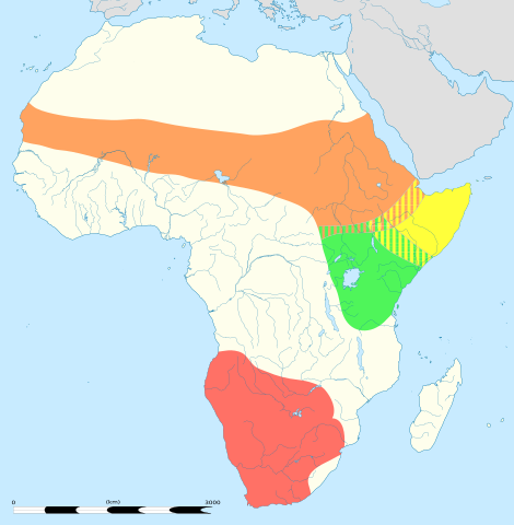
English: An updated version to reflect the correct Southern African distribution as per Sasol Birds of Southern Africa (2011) |
| ရက်စွဲ |
English: Blank administrative map of political Africa as in 2011-07, for geo-location purposes. On English Wikipedia, in "Template:Location_map_Africa" to set marker along curved latitude/longitude lines. Français : Carte administrative vierge de l'Afrique politique telle qu'en 07/2011, destinée à la géolocalisation. En Wikipédia Francais, a la Modèle:Géolocalisation/Afrique pour carte avec marqueur-image. A Lambert azimuthal equal-area projection, WGS84 datum *Standard meridian: 15°E *Standard parallel: 0° Scale: 1:23,420,000 (precision: 5,855 km) |
| ရင်းမြစ် |
This file was derived from: |
| စာရေးသူ |
|
| အခြား ဗားရှင်းများ | There is a version of this map with key and legends included in the graphic at File:Struthio camelus distribution with key.svg |

| This is a retouched picture, which means that it has been digitally altered from its original version. Modifications: redrawn/vectorised/combined. The original can be viewed here: Africa location map.svg:
|
လိုင်စင်သတ်မှတ်ခြင်း
ဤဖိုင်ကို Creative Commons Attribution-Share Alike 3.0 Unported လိုင်စင်ဖြင့် သတ်မှတ်ထားသည်။
- သင်သည် လွတ်လပ်စွာ:
- မျှဝေရန် – ဖန်တီးမှုကို ကူးယူရန်၊ ဖြန့်ဖြူးရန်နှင့် ထုတ်လွှင့်ရန်
- ပြန်ရောနှောရန် – ဖန်တီးမှုကို ပြင်ဆင်ညှိနှိုင်းရန်
- အောက်ပါ အခြေအနေများတွင်:
- မှတ်ယူနိုင်ခြင်း – ပြောင်းလဲမှုများ ပြုလုပ်ခဲ့ပါက ဖန်တီးသူ သို့မဟုတ် လိုင်စင်ရှိသူမှ သတ်မှတ်သော အမျိုးအစားကို လိုက်နာရမည် (ဆိုလိုသည်မှာ သင့်အား သို့မဟုတ် သင့်ဖန်တီးမှုတွင် အသုံးပြုခြင်းအား ထောက်ခံချက်ပေးသည်ဟု မဆိုလိုပါ)။
- ထပ်တူမျှဝေ – ဤဖန်တီးမှုအား ပြင်ဆင်ခြင်း၊ ပြောင်းလဲခြင်း သို့မဟုတ် ထပ်ဆင့် ဖန်တီးခြင်း ပြုလုပ်ပါက ရရှိလာသော ဖန်တီးမှုကို ဤဖန်တီးမှုနှင့် သို့မဟုတ် ဆင်တူသော လိုင်စင်ဖြင့်သာ ဖြန့်ချိသင့်သည်။
မူရင်းတင်ထားသောမှတ်တမ်း
This image is a derivative work of the following images:
- File:Struthio_camelus_Distribution_updated.png licensed with Cc-by-sa-3.0
- 2012-09-26T13:18:50Z Metatronx 1038x1270 (28425 Bytes) User created page with UploadWizard
- File:Africa_location_map.svg licensed with Cc-by-sa-3.0, GFDL
- 2012-10-02T12:40:15Z Palosirkka 1525x1440 (792744 Bytes) Reverted to version as of 19:13, 14 July 2011 Location maps must remain very accurate
- 2012-09-12T20:15:41Z Palosirkka 1525x1440 (537042 Bytes) Scrubbed with http://codedread.com/scour/
- 2011-07-14T19:13:55Z Sting 1525x1440 (792744 Bytes) Sudan/South Sudan 2011-07 border update
- 2010-07-02T20:12:15Z Sting 1525x1440 (586394 Bytes) == {{int:filedesc}} == {{Location|00|00|00|N|15|00|00|E|scale:30000000}} {{Information |Description={{en|Blank administrative map of political [[:en:Africa|Africa]], for geo-location purposes.}} {{fr|Carte administrative vier
Uploaded with derivativeFX
ဖိုင်မှတ်တမ်း
ဖိုင်ကို ယင်းနေ့စွဲ အတိုင်း မြင်နိုင်ရန် နေ့စွဲ/အချိန် တစ်ခုခုပေါ်တွင် ကလစ်နှိပ်ပါ။
| နေ့စွဲ/အချိန် | နမူနာပုံငယ် | မှတ်တမ်း ဒိုင်မန်းရှင်းများ | အသုံးပြုသူ | မှတ်ချက် | |
|---|---|---|---|---|---|
| ကာလပေါ် | ၀၅:၀၆၊ ၂၂ ဩဂုတ် ၂၀၁၃ | | ၆၈၇ × ၇၀၁ (၇၇၈ KB) | Begoon | position/keyline |
| ၁၈:၄၁၊ ၂၁ ဩဂုတ် ၂၀၁၃ |  | ၆၈၇ × ၇၀၁ (၉၀၂ KB) | Begoon | and re-crop | |
| ၁၈:၂၂၊ ၂၁ ဩဂုတ် ၂၀၁၃ |  | ၇၅၀ × ၇၀၅ (၉၀၁ KB) | Begoon | no legend | |
| ၁၈:၀၇၊ ၂၁ ဩဂုတ် ၂၀၁၃ |  | ၇၅၀ × ၇၀၅ (၉၃၂ KB) | Begoon | nah - better how it was | |
| ၁၈:၀၂၊ ၂၁ ဩဂုတ် ၂၀၁၃ |  | ၇၅၀ × ၇၀၅ (၉၃၂ KB) | Begoon | reduce legend size | |
| ၁၆:၀၆၊ ၂၁ ဩဂုတ် ၂၀၁၃ |  | ၇၅၀ × ၇၀၅ (၉၃၂ KB) | Begoon | tweak - square up legend key blocks after resize | |
| ၁၅:၄၁၊ ၂၁ ဩဂုတ် ၂၀၁၃ |  | ၇၅၀ × ၇၀၅ (၉၃၁ KB) | Begoon | shading | |
| ၁၄:၃၁၊ ၂၁ ဩဂုတ် ၂၀၁၃ |  | ၇၅၀ × ၇၀၅ (၉၁၄ KB) | Begoon | clearer colours for infobox | |
| ၁၃:၁၁၊ ၂၁ ဩဂုတ် ၂၀၁၃ |  | ၇၅၀ × ၇၀၅ (၉၁၉ KB) | Begoon | reduce yellow in land colour to increase yellow distrib area contrast | |
| ၁၂:၁၆၊ ၂၁ ဩဂုတ် ၂၀၁၃ |  | ၇၅၀ × ၇၀၅ (၉၁၉ KB) | Begoon | oops - fix crop properly |
ဖိုင်သုံးစွဲမှု
အောက်ပါ 2 စာမျက်နှာများ သည် ဤဖိုင်ကို အသုံးပြုထားသည်:
ဂလိုဘယ် ဖိုင်သုံးစွဲမှု
အောက်ပါ အခြားဝီကီများတွင် ဤဖိုင်ကို အသုံးပြုထားသည်-
- af.wikipedia.org တွင် အသုံးပြုမှု
- am.wikipedia.org တွင် အသုံးပြုမှု
- ar.wikipedia.org တွင် အသုံးပြုမှု
- azb.wikipedia.org တွင် အသုံးပြုမှု
- ba.wikipedia.org တွင် အသုံးပြုမှု
- cs.wikipedia.org တွင် အသုံးပြုမှု
- de.wikipedia.org တွင် အသုံးပြုမှု
- en.wikipedia.org တွင် အသုံးပြုမှု
- es.wikipedia.org တွင် အသုံးပြုမှု
- gl.wikipedia.org တွင် အသုံးပြုမှု
- ilo.wikipedia.org တွင် အသုံးပြုမှု
- is.wikipedia.org တွင် အသုံးပြုမှု
- it.wikipedia.org တွင် အသုံးပြုမှု
- kn.wikipedia.org တွင် အသုံးပြုမှု
- kw.wikipedia.org တွင် အသုံးပြုမှု
- lt.wikipedia.org တွင် အသုံးပြုမှု
- mk.wikipedia.org တွင် အသုံးပြုမှု
- ms.wikipedia.org တွင် အသုံးပြုမှု
- pa.wikipedia.org တွင် အသုံးပြုမှု
- pl.wikipedia.org တွင် အသုံးပြုမှု
- pt.wikipedia.org တွင် အသုံးပြုမှု
- ru.wikipedia.org တွင် အသုံးပြုမှု
- sco.wikipedia.org တွင် အသုံးပြုမှု
- simple.wikipedia.org တွင် အသုံးပြုမှု
- sl.wikipedia.org တွင် အသုံးပြုမှု
- tr.wikipedia.org တွင် အသုံးပြုမှု
- vi.wikipedia.org တွင် အသုံးပြုမှု
- wa.wikipedia.org တွင် အသုံးပြုမှု