
ဖိုင်:Saharat Thai Doem map.png

ဤနမူနာ၏ အရွယ်အစား - ၆၆၃ × ၆၀၀ ပစ်ဇယ်။ အခြား ပုံရိပ်ပြတ်သားမှု: ၂၆၅ × ၂၄၀ ပစ်ဇယ် | ၅၃၁ × ၄၈၀ ပစ်ဇယ် | ၉၆၂ × ၈၇၀ ပစ်ဇယ်။
မူရင်းဖိုင် (၉၆၂ × ၈၇၀ pixels, ဖိုင်အရွယ်အစား - ၁၈၉ KB, MIME အမျိုးအစား image/png)
| ဤဖိုင်သည် Wikimedia Commons မှဖြစ်ပြီး အခြားပရောဂျက်များတွင် သုံးကောင်းသုံးလိမ့်မည်။ ယင်း၏ ဖိုင်အကြောင်းစာမျက်နှာ တွင် ဖော်ပြထားချက်ကို အောက်တွင် ပြထားသည်။ Commons သည် မူပိုင်ခွင့်လွတ်လပ်သော မီဒီယာဖိုင်များ သိုလှောင်ထားရာ နေရာ ဖြစ်သည်။ သင်လည်း ပါဝင်ကူညီနိုင်ပါသည်။ |
အကျဉ်းချုပ်
| ဖော်ပြချက် |
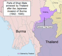
English: Parts of Shan State annexed by Thailand after the Japanese invasion of Burma. The map shows in purple the actual territories east of the Salween (Kengtung and part of Mongpan State) that were sanctioned by the Japanese authorities to become a new Thai province. Not all the territories claimed by Thailand in the Shan and Kayah states were granted by the Japanese.
Note: This is not a map of the farthest penetration of the Thai army accompanying the Japanese military in their Burma campaign. |
| ရက်စွဲ | |
| ရင်းမြစ် | ကိုယ်ပိုင်ဖန်တီးမှု |
| စာရေးသူ | Xufanc |
လိုင်စင်သတ်မှတ်ခြင်း
ကျွန်ုပ်၊ ဤလုပ်ဆောင်ချက်၏ မူပိုင်ခွင့်ပိုင်ရှင်အနေဖြင့် ဤနေရာမှ အောက်ပါလိုင်စင်အောက်တွင် ထုတ်လွှင့်ပါသည်:
ဤဖိုင်သည် Creative Commons Attribution-Share Alike 4.0 နိုင်ငံတကာ လိုင်စင်အောက်တွင် လိုင်စင်သတ်မှတ်ထားပါသည်။
- သင်သည် လွတ်လပ်စွာ:
- မျှဝေရန် – ဖန်တီးမှုကို ကူးယူရန်၊ ဖြန့်ဖြူးရန်နှင့် ထုတ်လွှင့်ရန်
- ပြန်ရောနှောရန် – ဖန်တီးမှုကို ပြင်ဆင်ညှိနှိုင်းရန်
- အောက်ပါ အခြေအနေများတွင်:
- မှတ်ယူနိုင်ခြင်း – ပြောင်းလဲမှုများ ပြုလုပ်ခဲ့ပါက ဖန်တီးသူ သို့မဟုတ် လိုင်စင်ရှိသူမှ သတ်မှတ်သော အမျိုးအစားကို လိုက်နာရမည် (ဆိုလိုသည်မှာ သင့်အား သို့မဟုတ် သင့်ဖန်တီးမှုတွင် အသုံးပြုခြင်းအား ထောက်ခံချက်ပေးသည်ဟု မဆိုလိုပါ)။
- ထပ်တူမျှဝေ – ဤဖန်တီးမှုအား ပြင်ဆင်ခြင်း၊ ပြောင်းလဲခြင်း သို့မဟုတ် ထပ်ဆင့် ဖန်တီးခြင်း ပြုလုပ်ပါက ရရှိလာသော ဖန်တီးမှုကို ဤဖန်တီးမှုနှင့် သို့မဟုတ် ဆင်တူသော လိုင်စင်ဖြင့်သာ ဖြန့်ချိသင့်သည်။
ဖိုင်မှတ်တမ်း
ဖိုင်ကို ယင်းနေ့စွဲ အတိုင်း မြင်နိုင်ရန် နေ့စွဲ/အချိန် တစ်ခုခုပေါ်တွင် ကလစ်နှိပ်ပါ။
| နေ့စွဲ/အချိန် | နမူနာပုံငယ် | မှတ်တမ်း ဒိုင်မန်းရှင်းများ | အသုံးပြုသူ | မှတ်ချက် | |
|---|---|---|---|---|---|
| ကာလပေါ် | ၁၃:၀၁၊ ၂၄ မေ ၂၀၁၇ | | ၉၆၂ × ၈၇၀ (၁၈၉ KB) | Xufanc | Undid malicious revision by User:Shoshui |
| ၀၃:၃၇၊ ၁၂ မတ် ၂၀၁၆ |  | ၉၆၂ × ၈၇၀ (၁၆၇ KB) | Shoshui | Reverted to version as of 07:52, 6 November 2015 (UTC) | |
| ၀၉:၃၇၊ ၁၅ ဒီဇင်ဘာ ၂၀၁၅ |  | ၉၆၂ × ၈၇၀ (၁၉၃ KB) | Xufanc | Corrected title | |
| ၀၉:၀၈၊ ၁၅ ဒီဇင်ဘာ ၂၀၁၅ |  | ၉၆၂ × ၈၇၀ (၁၉၄ KB) | Xufanc | Other wording | |
| ၀၈:၅၉၊ ၁၅ ဒီဇင်ဘာ ၂၀၁၅ |  | ၉၆၂ × ၈၇၀ (၂၀၈ KB) | Xufanc | Other wording | |
| ၀၁:၅၇၊ ၉ နိုဝင်ဘာ ၂၀၁၅ |  | ၉၆၂ × ၈၇၀ (၂၀၈ KB) | Xufanc | status unclear region | |
| ၀၃:၀၃၊ ၇ နိုဝင်ဘာ ၂၀၁၅ |  | ၉၆၂ × ၈၇၀ (၂၀၈ KB) | Xufanc | Status unclear region | |
| ၀၇:၅၂၊ ၆ နိုဝင်ဘာ ၂၀၁၅ |  | ၉၆၂ × ၈၇၀ (၁၆၇ KB) | Xufanc | Mandalay and Taunggiy was as far as the Thai troops advanced, but the map is about the parts annexed by Thailand as 'Saharat Thai Doem'. It is not a map of the farthest penetration of the Phayap Army | |
| ၀၆:၂၅၊ ၁၄ စက်တင်ဘာ ၂၀၁၅ |  | ၉၆၂ × ၈၇၀ (၁၆၆ KB) | Shoshui | The area include Mandalay and Taunggyi. | |
| ၀၆:၁၆၊ ၁၄ စက်တင်ဘာ ၂၀၁၅ |  | ၉၆၂ × ၈၇၀ (၁၆၆ KB) | Shoshui | The area include Mandalay and Taunggyi. |
ဖိုင်သုံးစွဲမှု
အောက်ပါ 2 စာမျက်နှာများ သည် ဤဖိုင်ကို အသုံးပြုထားသည်:
ဂလိုဘယ် ဖိုင်သုံးစွဲမှု
အောက်ပါ အခြားဝီကီများတွင် ဤဖိုင်ကို အသုံးပြုထားသည်-
- en.wikipedia.org တွင် အသုံးပြုမှု
- es.wikipedia.org တွင် အသုံးပြုမှု
- fr.wikipedia.org တွင် အသုံးပြုမှု
- it.wikipedia.org တွင် အသုံးပြုမှု
- ru.wikipedia.org တွင် အသုံးပြုမှု
- th.wikipedia.org တွင် အသုံးပြုမှု
- uk.wikipedia.org တွင် အသုံးပြုမှု
- vi.wikipedia.org တွင် အသုံးပြုမှု
- zh.wikipedia.org တွင် အသုံးပြုမှု