
ဖိုင်:ROC Administrative and Claims.svg

Size of this PNG preview of this SVG file: ၇၅၄ × ၆၀၀ ပစ်ဇယ်. အခြား ပုံရိပ်ပြတ်သားမှု: ၃၀၂ × ၂၄၀ ပစ်ဇယ် | ၆၀၃ × ၄၈၀ ပစ်ဇယ် | ၉၆၅ × ၇၆၈ ပစ်ဇယ် | ၁၂၈၀ × ၁၀၁၉ ပစ်ဇယ် | ၂၅၆၀ × ၂၀၃၇ ပစ်ဇယ်။
မူရင်းဖိုင် (SVG ဖိုင်, ၇၅၄ × ၆၀၀ pixels ကို အကြံပြုသည်, ဖိုင်အရွယ်အစား - ၆၇၆ KB)
| ဤဖိုင်သည် Wikimedia Commons မှဖြစ်ပြီး အခြားပရောဂျက်များတွင် သုံးကောင်းသုံးလိမ့်မည်။ ယင်း၏ ဖိုင်အကြောင်းစာမျက်နှာ တွင် ဖော်ပြထားချက်ကို အောက်တွင် ပြထားသည်။ Commons သည် မူပိုင်ခွင့်လွတ်လပ်သော မီဒီယာဖိုင်များ သိုလှောင်ထားရာ နေရာ ဖြစ်သည်။ သင်လည်း ပါဝင်ကူညီနိုင်ပါသည်။ |
အကျဉ်းချုပ်
| ဖော်ပြချက် |
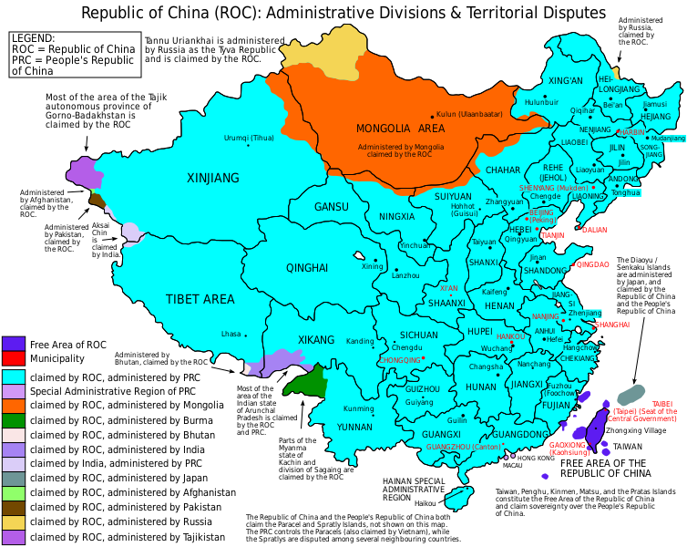
English: Map of the Republic of China (1953-2005), showing administrative divisions and territorial disputes. |
| ရက်စွဲ | (UTC) |
| ရင်းမြစ် | I (ZanderSchubert (talk)) created this work entirely by myself. |
| စာရေးသူ | User:ZanderSchubert |
| အခြား ဗားရှင်းများ |
Based on a previous version of File:ROC_Administrative_and_Claims.jpg See also the other versions of this file:
Derivative works of this file: |


|
This SVG file contains embedded text that can be translated into your language, using any capable SVG editor, text editor or the SVG Translate tool. For more information see: About translating SVG files. |
လိုင်စင်သတ်မှတ်ခြင်း
ကျွန်ုပ်၊ ဤလုပ်ဆောင်ချက်၏ မူပိုင်ခွင့်ပိုင်ရှင်အနေဖြင့် ဤနေရာမှ အောက်ပါလိုင်စင်များအောက်တွင် ထုတ်လွှင့်ပါသည်:

|
ဤစာတမ်းကို GNU Free Documentation License, ဗားရှင်း ၁.၂ သို့မဟုတ် Free Software Foundation မှ ဖြန့်ချီထားသော မည်သည့်ယခင်ဗားရှင်းတစ်ခုခုအောက်တွင် Invariant Sections, Front-Cover Texts နှင့် Back-Cover Texts များမပါဝင်ဘဲ ကူးယူခြင်း၊ ဖြန့်ချီခြင်း နှင့်/သို့မဟုတ် ပြင်ဆင်ပြောင်းလဲနိုင်ရန် ခွင့်ပြုသည်။ လိုင်စင်မူပွားကို GNU Free Documentation License ခေါင်းစဉ်အောက်တွင် ထည့်သွင်းထားသည်။ |
This file is licensed under the Creative Commons Attribution-Share Alike 4.0 International, 3.0 Unported, 2.5 Generic, 2.0 Generic and 1.0 Generic license.
- သင်သည် လွတ်လပ်စွာ:
- မျှဝေရန် – ဖန်တီးမှုကို ကူးယူရန်၊ ဖြန့်ဖြူးရန်နှင့် ထုတ်လွှင့်ရန်
- ပြန်ရောနှောရန် – ဖန်တီးမှုကို ပြင်ဆင်ညှိနှိုင်းရန်
- အောက်ပါ အခြေအနေများတွင်:
- မှတ်ယူနိုင်ခြင်း – ပြောင်းလဲမှုများ ပြုလုပ်ခဲ့ပါက ဖန်တီးသူ သို့မဟုတ် လိုင်စင်ရှိသူမှ သတ်မှတ်သော အမျိုးအစားကို လိုက်နာရမည် (ဆိုလိုသည်မှာ သင့်အား သို့မဟုတ် သင့်ဖန်တီးမှုတွင် အသုံးပြုခြင်းအား ထောက်ခံချက်ပေးသည်ဟု မဆိုလိုပါ)။
- ထပ်တူမျှဝေ – ဤဖန်တီးမှုအား ပြင်ဆင်ခြင်း၊ ပြောင်းလဲခြင်း သို့မဟုတ် ထပ်ဆင့် ဖန်တီးခြင်း ပြုလုပ်ပါက ရရှိလာသော ဖန်တီးမှုကို ဤဖန်တီးမှုနှင့် သို့မဟုတ် ဆင်တူသော လိုင်စင်ဖြင့်သာ ဖြန့်ချိသင့်သည်။
သင်အလိုရှိရာ လိုင်စင်ကို ရွေးချယ်နိုင်ပါသည်။
ဖိုင်မှတ်တမ်း
ဖိုင်ကို ယင်းနေ့စွဲ အတိုင်း မြင်နိုင်ရန် နေ့စွဲ/အချိန် တစ်ခုခုပေါ်တွင် ကလစ်နှိပ်ပါ။
| နေ့စွဲ/အချိန် | နမူနာပုံငယ် | မှတ်တမ်း ဒိုင်မန်းရှင်းများ | အသုံးပြုသူ | မှတ်ချက် | |
|---|---|---|---|---|---|
| ကာလပေါ် | ၁၀:၃၈၊ ၄ ဇွန် ၂၀၁၅ | | ၇၅၄ × ၆၀၀ (၆၇၆ KB) | Storkk | fix typo ("Most if ... Arunchal Pradesh" -> "Most of ...") |
| ၂၀:၀၉၊ ၂၅ ဒီဇင်ဘာ ၂၀၁၄ |  | ၇၅၄ × ၆၀၀ (၆၅၈ KB) | Koavf | Burma | |
| ၁၃:၂၄၊ ၄ မေ ၂၀၁၂ |  | ၇၅၄ × ၆၀၀ (၆၇၇ KB) | Michaeldsuarez | Removing typo: "[…] claimed by the Republic of China an the People's Republic of China" to "[…] claimed by the Republic of China and the People's Republic of China." | |
| ၀၈:၀၂၊ ၅ ဩဂုတ် ၂၀၁၁ |  | ၇၅၄ × ၆၀၀ (၆၇၇ KB) | ZanderSchubert | Changing place names to Pinyin and correcting some previous errors. | |
| ၀၁:၀၀၊ ၅ မေ ၂၀၁၁ |  | ၇၅၄ × ၆၀၀ (၆၇၅ KB) | ZanderSchubert | Changing "Republic of Mongolia" to "Mongolia" | |
| ၀၄:၂၂၊ ၁၂ ဖေဖော်ဝါရီ ၂၀၁၁ |  | ၇၅၄ × ၆၀၀ (၆၇၅ KB) | ZanderSchubert | {{Information |Description ={{en|1=Map of the Republic of China, showing administrative divisions and territorial disputes.}} |Source =I (ZanderSchubert (talk)) created this work entirely by |
ဖိုင်သုံးစွဲမှု
အောက်ပါ စာမျက်နှာ သည် ဤဖိုင်ကို အသုံးပြုထားသည်:
ဂလိုဘယ် ဖိုင်သုံးစွဲမှု
အောက်ပါ အခြားဝီကီများတွင် ဤဖိုင်ကို အသုံးပြုထားသည်-
- af.wikipedia.org တွင် အသုံးပြုမှု
- ar.wikipedia.org တွင် အသုံးပြုမှု
- ast.wikipedia.org တွင် အသုံးပြုမှု
- azb.wikipedia.org တွင် အသုံးပြုမှု
- ban.wikipedia.org တွင် အသုံးပြုမှု
- be-tarask.wikipedia.org တွင် အသုံးပြုမှု
- be.wikipedia.org တွင် အသုံးပြုမှု
- bn.wikipedia.org တွင် အသုံးပြုမှု
- ca.wikipedia.org တွင် အသုံးပြုမှု
- cs.wikipedia.org တွင် အသုံးပြုမှု
- de.wikipedia.org တွင် အသုံးပြုမှု
- el.wikipedia.org တွင် အသုံးပြုမှု
- en.wikipedia.org တွင် အသုံးပြုမှု
- Taiwan
- User:Jaques O. Carvalho
- Exclusive mandate
- User:Andyso/Userboxes
- User:Andyso/template:userboxes
- Template:User ROC Support
- Talk:2011 Cricket World Cup/Archive 2
- Talk:List of sovereign states/Archive 10
- Talk:Chinese civilization/Archive 26
- Talk:Sino-Burmese War/Move
- Wikipedia talk:WikiProject China/Archive 21
- Administrative divisions of the Republic of China (1912–1949)
- User:Skirtland/sandbox
- Wikipedia:Userboxes/Politics by country/05
- Talk:Taiwan/Archive 27
- User:Falcaorib
- Talk:COVID-19 pandemic/Archive 2
- User:DefinitelyNotNapoleon
- User:Pasingr
- User:TomcatEnthusiast1986
- User:Xevres/Sandbox
- User:Ezoiar/Userboxes
- eu.wikipedia.org တွင် အသုံးပြုမှု
- fa.wikipedia.org တွင် အသုံးပြုမှု
- fi.wikipedia.org တွင် အသုံးပြုမှု
- fr.wikipedia.org တွင် အသုံးပြုမှု
ဤဖိုင်ကို အခြားနေရာများတွင် အသုံးပြုထားမှုများအား ကြည့်ရှုရန်။