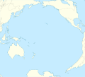
ဖိုင်:Pacific Ocean laea location map.svg

အခြားဘာသာစကားများဖြင့် စာမျက်နှာအကြောင်းအရာများကို ပံ့ပိုးမထားပါ။
This is a file from the Wikimedia Commons
ဝီကီပီးဒီးယား မှ

မူရင်းဖိုင်(SVG ဖိုင်, ၇၀၉ × ၆၄၅ pixels ကို အကြံပြုသည်, ဖိုင်အရွယ်အစား - ၂၁၇ KB)

Agemaps.com

အကျဉ်းချုပ်

ဖော်ပြချက်
English: Location map of Pacific Ocean.
  • Projection: Lambert azimuthal equal-area projection.
  • Area of interest:
  • N: 60.0° N
  • S: -80.0° N
  • W: -260.0° E
  • E: -70.0° E
  • Projection center:
  • NS: -10.0° N
  • WE: -165.0° E
  • GMT projection: -JA-165.0/-10.0/180/19.998266666666666c
  • GMT region: -R-320.2519138145009/-12.459450078533589/-5.473602099069988/26.40516525873812r
  • Land and shoreline: 1:110m Natural Earth Datasets, borders 1:50m
ရက်စွဲ
ရင်းမြစ် ကိုယ်ပိုင်ဖန်တီးမှု
စာရေးသူ Tentotwo

Shell script for generating the map using GMT archive copy at the Wayback Machine

#!/bin/sh

# Set common options
PROJECTION=A-165.0/-10.0/180/19.998266666666666c
REGION=-320.2519138145009/-12.459450078533589/-5.473602099069988/26.40516525873812r
FILENAME=Pacific_Ocean_laea_location_map.ps

# Get Natural Earth datafiles
echo "Downloading datafiles from naturalearthdata.com"
wget -nv -nc \
 http://www.naturalearthdata.com/http//www.naturalearthdata.com/download/110m/physical/110m-coastline.zip\
 http://www.naturalearthdata.com/http//www.naturalearthdata.com/download/110m/physical/110m-land.zip\
 http://www.naturalearthdata.com/http//www.naturalearthdata.com/download/110m/cultural/110m-admin-0-boundary-lines.zip
echo "...done\n"

echo "Inflating archives"
unzip 110m\*.zip
echo "...done\n"

echo "Converting shapefiles to GMT"
ogr2ogr -F GMT 110m_land.gmt 110m_land.shp
ogr2ogr -F GMT 110m_coastline.gmt 110m_coastline.shp
ogr2ogr -F GMT 50m_borders.gmt ne_50m_admin_0_boundary_lines_land.shp
echo "...done\n"

echo "Creating maps"
GMT psxy -m -J$PROJECTION -R$REGION --PAGE_COLOR=198/236/255  --POLAR_CAP=none --PAPER_MEDIA=A3  --BASEMAP_TYPE=plain --BASEMAP_AXES=NESW --FRAME_PEN=0.15p,black 110m_land.gmt -K -G254/254/233 > $FILENAME
GMT psxy -m -J$PROJECTION -R$REGION 110m_coastline.gmt -O -K -W0.535p,9/120/171  >> $FILENAME
GMT psxy -m -J$PROJECTION -R$REGION 50m_borders.gmt -O -W100/100/100  >> $FILENAME
echo "...done\n"

echo "You can now open $FILENAME in Inkscape to clean up the file and save it as SVG. You should add an ocean coloured background and simplify the graticules using CTRL+L."

gv $FILENAME

လိုင်စင်သတ်မှတ်ခြင်း

ကျွန်ုပ်၊ ဤလုပ်ဆောင်ချက်၏ မူပိုင်ခွင့်ပိုင်ရှင်အနေဖြင့် ဤနေရာမှ အောက်ပါလိုင်စင်အောက်တွင် ထုတ်လွှင့်ပါသည်:
w:my:Creative Commons
မှတ်ယူနိုင်ခြင်း ထပ်တူမျှဝေ
ဤဖိုင်ကို Creative Commons Attribution-Share Alike 3.0 Unported လိုင်စင်ဖြင့် သတ်မှတ်ထားသည်။
သင်သည် လွတ်လပ်စွာ:
  • မျှဝေရန် – ဖန်တီးမှုကို ကူးယူရန်၊ ဖြန့်ဖြူးရန်နှင့် ထုတ်လွှင့်ရန်
  • ပြန်ရောနှောရန် – ဖန်တီးမှုကို ပြင်ဆင်ညှိနှိုင်းရန်
အောက်ပါ အခြေအနေများတွင်:
  • မှတ်ယူနိုင်ခြင်း – ပြောင်းလဲမှုများ ပြုလုပ်ခဲ့ပါက ဖန်တီးသူ သို့မဟုတ် လိုင်စင်ရှိသူမှ သတ်မှတ်သော အမျိုးအစားကို လိုက်နာရမည် (ဆိုလိုသည်မှာ သင့်အား သို့မဟုတ် သင့်ဖန်တီးမှုတွင် အသုံးပြုခြင်းအား ထောက်ခံချက်ပေးသည်ဟု မဆိုလိုပါ)။
  • ထပ်တူမျှဝေ – ဤဖန်တီးမှုအား ပြင်ဆင်ခြင်း၊ ပြောင်းလဲခြင်း သို့မဟုတ် ထပ်ဆင့် ဖန်တီးခြင်း ပြုလုပ်ပါက ရရှိလာသော ဖန်တီးမှုကို ဤဖန်တီးမှုနှင့် သို့မဟုတ် ဆင်တူသော လိုင်စင်ဖြင့်သာ ဖြန့်ချိသင့်သည်။

ပုံစာများ

ဤဖိုင်၏ဆိုလိုရင်းကို စာတစ်ကြောင်းရှင်းလင်းချက်ဖြင့် ထည့်သွင်းရန်

Items portrayed in this file

depicts အင်္ဂလိပ်

၁ ဖေဖော်ဝါရီ 2012

ဖိုင်မှတ်တမ်း

ဖိုင်ကို ယင်းနေ့စွဲ အတိုင်း မြင်နိုင်ရန် နေ့စွဲ/အချိန် တစ်ခုခုပေါ်တွင် ကလစ်နှိပ်ပါ။

နေ့စွဲ/အချိန်နမူနာပုံငယ်မှတ်တမ်း ဒိုင်မန်းရှင်းများအသုံးပြုသူမှတ်ချက်
ကာလပေါ် ၁၀:၅၁၊ ၁ ဖေဖော်ဝါရီ ၂၀၁၂ ၁၀:၅၁၊ ၁ ဖေဖော်ဝါရီ ၂၀၁၂ ရက်က မူအတွက် နမူနာပုံငယ်၇၀၉ × ၆၄၅ (၂၁၇ KB)TentotwoFixed missing colour in Asia
၁၀:၀၀၊ ၁ ဖေဖော်ဝါရီ ၂၀၁၂ ၁၀:၀၀၊ ၁ ဖေဖော်ဝါရီ ၂၀၁၂ ရက်က မူအတွက် နမူနာပုံငယ်၇၀၉ × ၆၄၅ (၂၃၅ KB)Tentotwo

အောက်ပါ 5 စာမျက်နှာများ သည် ဤဖိုင်ကို အသုံးပြုထားသည်:

ဂလိုဘယ် ဖိုင်သုံးစွဲမှု

အောက်ပါ အခြားဝီကီများတွင် ဤဖိုင်ကို အသုံးပြုထားသည်-

ဤဖိုင်ကို အခြားနေရာများတွင် အသုံးပြုထားမှုများအား ကြည့်ရှုရန်။