
ဖိုင်:Netherlands-CIA WFB Map.png
သည်ထက်ကြီးသော resolution မရှိပါ.
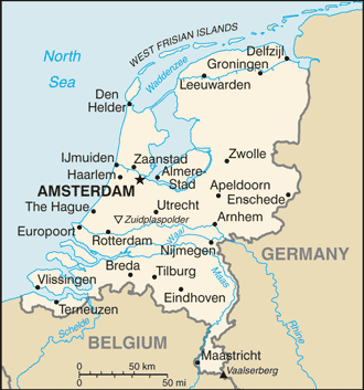
Netherlands-CIA_WFB_Map.png (၃၃၀ × ၃၅၃ pixels, ဖိုင်အရွယ်အစား - ၆၅ KB, MIME အမျိုးအစား image/png)
| ဤဖိုင်သည် Wikimedia Commons မှဖြစ်ပြီး အခြားပရောဂျက်များတွင် သုံးကောင်းသုံးလိမ့်မည်။ ယင်း၏ ဖိုင်အကြောင်းစာမျက်နှာ တွင် ဖော်ပြထားချက်ကို အောက်တွင် ပြထားသည်။ Commons သည် မူပိုင်ခွင့်လွတ်လပ်သော မီဒီယာဖိုင်များ သိုလှောင်ထားရာ နေရာ ဖြစ်သည်။ သင်လည်း ပါဝင်ကူညီနိုင်ပါသည်။ |
| ဖော်ပြချက် | Map of the Netherlands |
| ရင်းမြစ် | CIA World Factbook |
| စာရေးသူ | CIA |
| အခြား ဗားရှင်းများ |
Derivative works of this file: Netherlands-CIA WFB Map-10-10-10.png Dutch; Norwegian; English (2004) |
.png)
This image is in the public domain because it contains materials that originally came from the United States Central Intelligence Agency's World Factbook.
|
 |
ဖိုင်မှတ်တမ်း
ဖိုင်ကို ယင်းနေ့စွဲ အတိုင်း မြင်နိုင်ရန် နေ့စွဲ/အချိန် တစ်ခုခုပေါ်တွင် ကလစ်နှိပ်ပါ။
| နေ့စွဲ/အချိန် | နမူနာပုံငယ် | မှတ်တမ်း ဒိုင်မန်းရှင်းများ | အသုံးပြုသူ | မှတ်ချက် | |
|---|---|---|---|---|---|
| ကာလပေါ် | ၁၆:၃၅၊ ၁၄ စက်တင်ဘာ ၂၀၁၉ | | ၃၃၀ × ၃၅၃ (၆၅ KB) | Thayts | Borkum to Germany |
| ၀၂:၂၈၊ ၂၆ ဇူလိုင် ၂၀၀၈ |  | ၃၃၀ × ၃၅၃ (၂၁ KB) | Hoshie | updated map of Netherlands from the CIA World Factbook - 24 July 2008 edition: https://www.cia.gov/library/publications/the-world-factbook/maps/nl-map.gif | |
| ၀၉:၁၆၊ ၂၇ မတ် ၂၀၀၅ |  | ၃၃၀ × ၃၅၅ (၁၀ KB) | Wolfman~commonswiki | {{CIA-map}} |
ဖိုင်သုံးစွဲမှု
ဤဖိုင်ကို အသုံးပြုထားသော စာမျက်နှာများမရှိပါ။
ဂလိုဘယ် ဖိုင်သုံးစွဲမှု
အောက်ပါ အခြားဝီကီများတွင် ဤဖိုင်ကို အသုံးပြုထားသည်-
- ar.wikipedia.org တွင် အသုံးပြုမှု
- de.wikipedia.org တွင် အသုံးပြုမှု
- en.wikipedia.org တွင် အသုံးပြုမှု
- en.wikisource.org တွင် အသုံးပြုမှု
- eu.wikipedia.org တွင် အသုံးပြုမှု
- gag.wikipedia.org တွင် အသုံးပြုမှု
- he.wikipedia.org တွင် အသုံးပြုမှု
- hu.wikipedia.org တွင် အသုံးပြုမှု
- hu.wiktionary.org တွင် အသုံးပြုမှု
- ka.wikipedia.org တွင် အသုံးပြုမှု
- mr.wikipedia.org တွင် အသုံးပြုမှု
- pl.wikipedia.org တွင် အသုံးပြုမှု
- pt.wikipedia.org တွင် အသုံးပြုမှု
- ru.wikipedia.org တွင် အသုံးပြုမှု
- sq.wikipedia.org တွင် အသုံးပြုမှု
- zh.wikipedia.org တွင် အသုံးပြုမှု