
ဖိုင်:Netherlands-CIA WFB Map-10-10-10.png
သည်ထက်ကြီးသော resolution မရှိပါ.
Netherlands-CIA_WFB_Map-10-10-10.png (၃၃၀ × ၃၅၃ pixels, ဖိုင်အရွယ်အစား - ၆၈ KB, MIME အမျိုးအစား image/png)
| ဤဖိုင်သည် Wikimedia Commons မှဖြစ်ပြီး အခြားပရောဂျက်များတွင် သုံးကောင်းသုံးလိမ့်မည်။ ယင်း၏ ဖိုင်အကြောင်းစာမျက်နှာ တွင် ဖော်ပြထားချက်ကို အောက်တွင် ပြထားသည်။ Commons သည် မူပိုင်ခွင့်လွတ်လပ်သော မီဒီယာဖိုင်များ သိုလှောင်ထားရာ နေရာ ဖြစ်သည်။ သင်လည်း ပါဝင်ကူညီနိုင်ပါသည်။ |
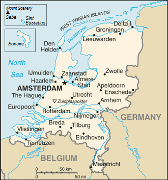
| ဖော်ပြချက် | Map of the Netherlands |
| ရက်စွဲ | (UTC) |
| ရင်းမြစ် | |
| စာရေးသူ |
|
| This is a retouched picture, which means that it has been digitally altered from its original version. The original can be viewed here: Netherlands-CIA WFB Map.png:
|
This image is in the public domain because it contains materials that originally came from the United States Central Intelligence Agency's World Factbook.
|
 |
မူရင်းတင်ထားသောမှတ်တမ်း
This image is a derivative work of the following images:
- File:Netherlands-CIA_WFB_Map.png licensed with PD-USGov-CIA-WF
Uploaded with derivativeFX
ဖိုင်မှတ်တမ်း
ဖိုင်ကို ယင်းနေ့စွဲ အတိုင်း မြင်နိုင်ရန် နေ့စွဲ/အချိန် တစ်ခုခုပေါ်တွင် ကလစ်နှိပ်ပါ။
| နေ့စွဲ/အချိန် | နမူနာပုံငယ် | မှတ်တမ်း ဒိုင်မန်းရှင်းများ | အသုံးပြုသူ | မှတ်ချက် | |
|---|---|---|---|---|---|
| ကာလပေါ် | ၁၆:၁၇၊ ၁၄ စက်တင်ဘာ ၂၀၁၉ | | ၃၃၀ × ၃၅၃ (၆၈ KB) | Thayts | Borkum to Germany |
| ၁၁:၄၀၊ ၇ ဒီဇင်ဘာ ၂၀၁၀ |  | ၃၃၀ × ၃၅၃ (၃၃ KB) | LennartBolks~commonswiki | {{Information |Description=Map of the Netherlands |Source=*File:Netherlands-CIA_WFB_Map.png |Date=2010-12-07 11:39 (UTC) |Author=*File:Netherlands-CIA_WFB_Map.png: CIA *derivative work: ~~~ |Permission= |other_versions= }} {{RetouchedPicture| |
ဖိုင်သုံးစွဲမှု
အောက်ပါ စာမျက်နှာ သည် ဤဖိုင်ကို အသုံးပြုထားသည်:
ဂလိုဘယ် ဖိုင်သုံးစွဲမှု
အောက်ပါ အခြားဝီကီများတွင် ဤဖိုင်ကို အသုံးပြုထားသည်-
- dsb.wikipedia.org တွင် အသုံးပြုမှု
- en.wikipedia.org တွင် အသုံးပြုမှု
- en.wikiversity.org တွင် အသုံးပြုမှု
- gom.wikipedia.org တွင် အသုံးပြုမှု
- incubator.wikimedia.org တွင် အသုံးပြုမှု
- ja.wikipedia.org တွင် အသုံးပြုမှု
- lt.wiktionary.org တွင် အသုံးပြုမှု
- ms.wikipedia.org တွင် အသုံးပြုမှု
- mt.wikipedia.org တွင် အသုံးပြုမှု
- pl.wikipedia.org တွင် အသုံးပြုမှု
- pl.wikivoyage.org တွင် အသုံးပြုမှု
- ps.wikipedia.org တွင် အသုံးပြုမှု
- pt.wikipedia.org တွင် အသုံးပြုမှု
- ro.wikipedia.org တွင် အသုံးပြုမှု
- simple.wikipedia.org တွင် အသုံးပြုမှု
- sq.wikipedia.org တွင် အသုံးပြုမှု
- szl.wikipedia.org တွင် အသုံးပြုမှု
- to.wikipedia.org တွင် အသုံးပြုမှု
- www.wikidata.org တွင် အသုံးပြုမှု