
ဖိုင်:Moon map grid showing artificial objects on moon.PNG
ဤနမူနာ၏ အရွယ်အစား - ၈၀၀ × ၄၅၀ ပစ်ဇယ်။ အခြား ပုံရိပ်ပြတ်သားမှု: ၃၂၀ × ၁၈၀ ပစ်ဇယ် | ၆၄၀ × ၃၆၀ ပစ်ဇယ် | ၁၀၂၄ × ၅၇၆ ပစ်ဇယ် | ၁၂၈၀ × ၇၂၀ ပစ်ဇယ် | ၂၅၆၀ × ၁၄၄၀ ပစ်ဇယ်။
မူရင်းဖိုင် (၂၅၆၀ × ၁၄၄၀ pixels, ဖိုင်အရွယ်အစား - ၅၁၀ KB, MIME အမျိုးအစား image/png)
| ဤဖိုင်သည် Wikimedia Commons မှဖြစ်ပြီး အခြားပရောဂျက်များတွင် သုံးကောင်းသုံးလိမ့်မည်။ ယင်း၏ ဖိုင်အကြောင်းစာမျက်နှာ တွင် ဖော်ပြထားချက်ကို အောက်တွင် ပြထားသည်။ Commons သည် မူပိုင်ခွင့်လွတ်လပ်သော မီဒီယာဖိုင်များ သိုလှောင်ထားရာ နေရာ ဖြစ်သည်။ သင်လည်း ပါဝင်ကူညီနိုင်ပါသည်။ |
အကျဉ်းချုပ်
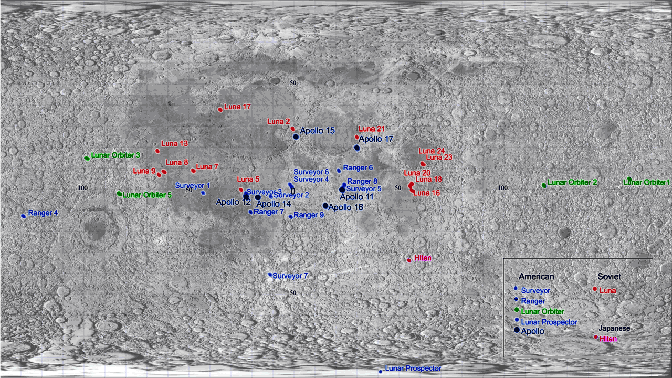
| ဖော်ပြချက် | Grid showing artificial objects on the moon, axis shows latitude and longitude. made from information from w:List of artificial objects on the Moon. I made the image. |
| ရက်စွဲ | ၂ ဒီဇင်ဘာ ၂၀၀၅ (original upload date) |
| ရင်းမြစ် | No machine-readable source provided. Own work assumed (based on copyright claims). |
| စာရေးသူ | No machine-readable author provided. Roke~commonswiki assumed (based on copyright claims). |
လိုင်စင်သတ်မှတ်ခြင်း
ကျွန်ုပ်၊ ဤလုပ်ဆောင်ချက်၏ မူပိုင်ခွင့်ပိုင်ရှင်အနေဖြင့် ဤနေရာမှ အောက်ပါလိုင်စင်များအောက်တွင် ထုတ်လွှင့်ပါသည်:

|
ဤစာတမ်းကို GNU Free Documentation License, ဗားရှင်း ၁.၂ သို့မဟုတ် Free Software Foundation မှ ဖြန့်ချီထားသော မည်သည့်ယခင်ဗားရှင်းတစ်ခုခုအောက်တွင် Invariant Sections, Front-Cover Texts နှင့် Back-Cover Texts များမပါဝင်ဘဲ ကူးယူခြင်း၊ ဖြန့်ချီခြင်း နှင့်/သို့မဟုတ် ပြင်ဆင်ပြောင်းလဲနိုင်ရန် ခွင့်ပြုသည်။ လိုင်စင်မူပွားကို GNU Free Documentation License ခေါင်းစဉ်အောက်တွင် ထည့်သွင်းထားသည်။ |
| ဤဖိုင်ကို Creative Commons Attribution-Share Alike 3.0 Unported လိုင်စင်ဖြင့် သတ်မှတ်ထားသည်။ | ||
| ||
| This licensing tag was added to this file as part of the GFDL licensing update. |
သင်အလိုရှိရာ လိုင်စင်ကို ရွေးချယ်နိုင်ပါသည်။
| Annotations | This image is annotated: View the annotations at Commons |
ဖိုင်မှတ်တမ်း
ဖိုင်ကို ယင်းနေ့စွဲ အတိုင်း မြင်နိုင်ရန် နေ့စွဲ/အချိန် တစ်ခုခုပေါ်တွင် ကလစ်နှိပ်ပါ။
| နေ့စွဲ/အချိန် | နမူနာပုံငယ် | မှတ်တမ်း ဒိုင်မန်းရှင်းများ | အသုံးပြုသူ | မှတ်ချက် | |
|---|---|---|---|---|---|
| ကာလပေါ် | ၂၃:၀၄၊ ၂၆ မတ် ၂၀၁၁ | | ၂၅၆၀ × ၁၄၄၀ (၅၁၀ KB) | Cmglee | Fix Apollo 14 location. |
| ၂၂:၂၂၊ ၂၆ မတ် ၂၀၁၁ |  | ၂၅၆၀ × ၁၄၄၀ (၅၁၀ KB) | Cmglee | Add background from Clementine data File:Moonmap from clementine data.png. | |
| ၀၂:၀၁၊ ၃၁ ဇူလိုင် ၂၀၀၆ |  | ၂၅၄၀ × ၁၄၄၈ (၁၂၈ KB) | Roke~commonswiki | crop, shouldnt have gone past 90 degrees latitude | |
| ၁၄:၁၉၊ ၂ ဒီဇင်ဘာ ၂၀၀၅ |  | ၂၅၄၀ × ၁၈၂၈ (၁၄၆ KB) | Roke~commonswiki | Grid showing artificial objects on the moon, made from information from w:List of artificial objects on the Moon. I made the image. Category: Moon |
ဖိုင်သုံးစွဲမှု
အောက်ပါ စာမျက်နှာ သည် ဤဖိုင်ကို အသုံးပြုထားသည်:
ဂလိုဘယ် ဖိုင်သုံးစွဲမှု
အောက်ပါ အခြားဝီကီများတွင် ဤဖိုင်ကို အသုံးပြုထားသည်-
- ar.wikipedia.org တွင် အသုံးပြုမှု
- bg.wikipedia.org တွင် အသုံးပြုမှု
- blk.wikipedia.org တွင် အသုံးပြုမှု
- ca.wikipedia.org တွင် အသုံးပြုမှု
- de.wikipedia.org တွင် အသုံးပြုမှု
- en.wikipedia.org တွင် အသုံးပြုမှု
- es.wikipedia.org တွင် အသုံးပြုမှု
- fa.wikipedia.org တွင် အသုံးပြုမှု
- fi.wikipedia.org တွင် အသုံးပြုမှု
- fr.wikipedia.org တွင် အသုံးပြုမှု
- id.wikipedia.org တွင် အသုံးပြုမှု
- it.wikipedia.org တွင် အသုံးပြုမှု
- kk.wikipedia.org တွင် အသုံးပြုမှု
- lb.wikipedia.org တွင် အသုံးပြုမှု
- pl.wikipedia.org တွင် အသုံးပြုမှု
- pt.wikipedia.org တွင် အသုံးပြုမှု
- ru.wikipedia.org တွင် အသုံးပြုမှု
- uk.wikipedia.org တွင် အသုံးပြုမှု