
ဖိုင်:Military districts of Russia 2016.svg

Size of this PNG preview of this SVG file: ၈၀၀ × ၄၅၅ ပစ်ဇယ်. အခြား ပုံရိပ်ပြတ်သားမှု: ၃၂၀ × ၁၈၂ ပစ်ဇယ် | ၆၄၀ × ၃၆၄ ပစ်ဇယ် | ၁၀၂၄ × ၅၈၃ ပစ်ဇယ် | ၁၂၈၀ × ၇၂၈ ပစ်ဇယ် | ၂၅၆၀ × ၁၄၅၇ ပစ်ဇယ် | ၁၁၀၇ × ၆၃၀ ပစ်ဇယ်။
မူရင်းဖိုင် (SVG ဖိုင်, ၁၁၀၇ × ၆၃၀ pixels ကို အကြံပြုသည်, ဖိုင်အရွယ်အစား - ၂၆၃ KB)
| ဤဖိုင်သည် Wikimedia Commons မှဖြစ်ပြီး အခြားပရောဂျက်များတွင် သုံးကောင်းသုံးလိမ့်မည်။ ယင်း၏ ဖိုင်အကြောင်းစာမျက်နှာ တွင် ဖော်ပြထားချက်ကို အောက်တွင် ပြထားသည်။ Commons သည် မူပိုင်ခွင့်လွတ်လပ်သော မီဒီယာဖိုင်များ သိုလှောင်ထားရာ နေရာ ဖြစ်သည်။ သင်လည်း ပါဝင်ကူညီနိုင်ပါသည်။ |

|
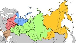
The boundaries on this map show the de facto situation. This is just one of several different views on the subject (see COM:NPOV). |
အကျဉ်းချုပ်
| ဖော်ပြချက် |
Русский: Военно-административное деление территории Российской Федерации с 15 декабря 2014 года
Западный военный округ
Северный флот
Южный военный округ
Центральный военный округ
Восточный военный округ English: Areas of responsibility of the 5 Operational Strategic Commands of the Russian Armed Forces since Dec 15th, 2014
Western Operational Strategic Command
Northern Fleet
Southern Operational Strategic Command
Central Operational Strategic Command
Eastern Operational Strategic Command |
| ရက်စွဲ | |
| ရင်းမြစ် | |
| စာရေးသူ | AlexWelens |

လိုင်စင်သတ်မှတ်ခြင်း
ကျွန်ုပ်၊ ဤလုပ်ဆောင်ချက်၏ မူပိုင်ခွင့်ပိုင်ရှင်အနေဖြင့် ဤနေရာမှ အောက်ပါလိုင်စင်အောက်တွင် ထုတ်လွှင့်ပါသည်:
ဤဖိုင်သည် Creative Commons Attribution-Share Alike 4.0 နိုင်ငံတကာ လိုင်စင်အောက်တွင် လိုင်စင်သတ်မှတ်ထားပါသည်။
- သင်သည် လွတ်လပ်စွာ:
- မျှဝေရန် – ဖန်တီးမှုကို ကူးယူရန်၊ ဖြန့်ဖြူးရန်နှင့် ထုတ်လွှင့်ရန်
- ပြန်ရောနှောရန် – ဖန်တီးမှုကို ပြင်ဆင်ညှိနှိုင်းရန်
- အောက်ပါ အခြေအနေများတွင်:
- မှတ်ယူနိုင်ခြင်း – ပြောင်းလဲမှုများ ပြုလုပ်ခဲ့ပါက ဖန်တီးသူ သို့မဟုတ် လိုင်စင်ရှိသူမှ သတ်မှတ်သော အမျိုးအစားကို လိုက်နာရမည် (ဆိုလိုသည်မှာ သင့်အား သို့မဟုတ် သင့်ဖန်တီးမှုတွင် အသုံးပြုခြင်းအား ထောက်ခံချက်ပေးသည်ဟု မဆိုလိုပါ)။
- ထပ်တူမျှဝေ – ဤဖန်တီးမှုအား ပြင်ဆင်ခြင်း၊ ပြောင်းလဲခြင်း သို့မဟုတ် ထပ်ဆင့် ဖန်တီးခြင်း ပြုလုပ်ပါက ရရှိလာသော ဖန်တီးမှုကို ဤဖန်တီးမှုနှင့် သို့မဟုတ် ဆင်တူသော လိုင်စင်ဖြင့်သာ ဖြန့်ချိသင့်သည်။
ဖိုင်မှတ်တမ်း
ဖိုင်ကို ယင်းနေ့စွဲ အတိုင်း မြင်နိုင်ရန် နေ့စွဲ/အချိန် တစ်ခုခုပေါ်တွင် ကလစ်နှိပ်ပါ။
| နေ့စွဲ/အချိန် | နမူနာပုံငယ် | မှတ်တမ်း ဒိုင်မန်းရှင်းများ | အသုံးပြုသူ | မှတ်ချက် | |
|---|---|---|---|---|---|
| ကာလပေါ် | ၂၂:၅၆၊ ၂၃ ဒီဇင်ဘာ ၂၀၂၀ | | ၁၁၀၇ × ၆၃၀ (၂၆၃ KB) | AlexWelens | fixed islands according map at mil.ru |
| ၁၅:၀၆၊ ၁၇ ဖေဖော်ဝါရီ ၂၀၁၇ |  | ၁၁၀၇ × ၆၃၀ (၂၆၃ KB) | AlexWelens | Reverted to version as of 16:50, 15 July 2016 (UTC) | |
| ၀၁:၃၈၊ ၉ ဖေဖော်ဝါရီ ၂၀၁၇ |  | ၁၁၀၇ × ၆၃၀ (၄၈၉ KB) | Metrancya | The Northern Fleet area of responsibility is only a part of the area of the new "Unified Strategic Command »North«. All territories north of the Arctic Circle will in the future be governed by the "Unified Strategic Command »North«, which then will... | |
| ၁၆:၅၀၊ ၁၅ ဇူလိုင် ၂၀၁၆ |  | ၁၁၀၇ × ၆၃၀ (၂၆၃ KB) | AlexWelens | User created page with UploadWizard |
ဖိုင်သုံးစွဲမှု
အောက်ပါ စာမျက်နှာ သည် ဤဖိုင်ကို အသုံးပြုထားသည်:
ဂလိုဘယ် ဖိုင်သုံးစွဲမှု
အောက်ပါ အခြားဝီကီများတွင် ဤဖိုင်ကို အသုံးပြုထားသည်-
- ar.wikipedia.org တွင် အသုံးပြုမှု
- ast.wikipedia.org တွင် အသုံးပြုမှု
- be-tarask.wikipedia.org တွင် အသုံးပြုမှု
- bg.wikipedia.org တွင် အသုံးပြုမှု
- cs.wikipedia.org တွင် အသုံးပြုမှု
- da.wikipedia.org တွင် အသုံးပြုမှု
- de.wikipedia.org တွင် အသုံးပြုမှု
- en.wikipedia.org တွင် အသုံးပြုမှု
- es.wikipedia.org တွင် အသုံးပြုမှု
- et.wikipedia.org တွင် အသုံးပြုမှု
- fi.wikipedia.org တွင် အသုံးပြုမှု
- fr.wikipedia.org တွင် အသုံးပြုမှု
- he.wikipedia.org တွင် အသုံးပြုမှု
- hu.wikipedia.org တွင် အသုံးပြုမှု
- it.wikipedia.org တွင် အသုံးပြုမှု
- ja.wikipedia.org တွင် အသုံးပြုမှု
ဤဖိုင်ကို အခြားနေရာများတွင် အသုံးပြုထားမှုများအား ကြည့်ရှုရန်။