
ဖိုင်:Location French Polynesia.png
သည်ထက်ကြီးသော resolution မရှိပါ.
Location_French_Polynesia.png (၂၅၀ × ၁၅၈ pixels, ဖိုင်အရွယ်အစား - ၉ KB, MIME အမျိုးအစား image/png)
| ဤဖိုင်သည် Wikimedia Commons မှဖြစ်ပြီး အခြားပရောဂျက်များတွင် သုံးကောင်းသုံးလိမ့်မည်။ ယင်း၏ ဖိုင်အကြောင်းစာမျက်နှာ တွင် ဖော်ပြထားချက်ကို အောက်တွင် ပြထားသည်။ Commons သည် မူပိုင်ခွင့်လွတ်လပ်သော မီဒီယာဖိုင်များ သိုလှောင်ထားရာ နေရာ ဖြစ်သည်။ သင်လည်း ပါဝင်ကူညီနိုင်ပါသည်။ |
အကျဉ်းချုပ်
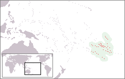
| ဖော်ပြချက် | Location of French-Polynesia |
| ရက်စွဲ | ၁၉ မေ ၂၀၀၅ (original upload date) |
| ရင်းမြစ် | ကိုယ်ပိုင်ဖန်တီးမှု |
| စာရေးသူ | Mixcoatl at ဒတ်ခ်ျ ဝီကီပီးဒီးယား |

|
This locator map image could be re-created using vector graphics as an SVG file. This has several advantages; see Commons:Media for cleanup for more information. If an SVG form of this image is available, please upload it and afterwards replace this template with
{{vector version available|new image name}}.
It is recommended to name the SVG file “Location French Polynesia.svg”—then the template Vector version available (or Vva) does not need the new image name parameter. |
လိုင်စင်သတ်မှတ်ခြင်း
Mixcoatl at ဒတ်ခ်ျ ဝီကီပီးဒီးယား၊ ဤလုပ်ဆောင်ချက်၏ မူပိုင်ခွင့်ပိုင်ရှင်အနေဖြင့် ဤနေရာမှ အောက်ပါလိုင်စင်များအောက်တွင် ထုတ်လွှင့်ပါသည်:

|
ဤစာတမ်းကို GNU Free Documentation License, ဗားရှင်း ၁.၂ သို့မဟုတ် Free Software Foundation မှ ဖြန့်ချီထားသော မည်သည့်ယခင်ဗားရှင်းတစ်ခုခုအောက်တွင် Invariant Sections, Front-Cover Texts နှင့် Back-Cover Texts များမပါဝင်ဘဲ ကူးယူခြင်း၊ ဖြန့်ချီခြင်း နှင့်/သို့မဟုတ် ပြင်ဆင်ပြောင်းလဲနိုင်ရန် ခွင့်ပြုသည်။ လိုင်စင်မူပွားကို GNU Free Documentation License ခေါင်းစဉ်အောက်တွင် ထည့်သွင်းထားသည်။ |
| ဤဖိုင်ကို Creative Commons Attribution-Share Alike 3.0 Unported လိုင်စင်ဖြင့် သတ်မှတ်ထားသည်။ | ||
| မှတ်ယူနိုင်ခြင်း: Mixcoatl at ဒတ်ခ်ျ ဝီကီပီးဒီးယား | ||
| ||
| This licensing tag was added to this file as part of the GFDL licensing update. |
ဤဖိုင်သည် Creative Commons Attribution-Share Alike 2.5 Generic လိုင်စင်အောက်တွင် လိုင်စင်သတ်မှတ်ထားပါသည်။
မှတ်ယူနိုင်ခြင်း: Mixcoatl at ဒတ်ခ်ျ ဝီကီပီးဒီးယား
- သင်သည် လွတ်လပ်စွာ:
- မျှဝေရန် – ဖန်တီးမှုကို ကူးယူရန်၊ ဖြန့်ဖြူးရန်နှင့် ထုတ်လွှင့်ရန်
- ပြန်ရောနှောရန် – ဖန်တီးမှုကို ပြင်ဆင်ညှိနှိုင်းရန်
- အောက်ပါ အခြေအနေများတွင်:
- မှတ်ယူနိုင်ခြင်း – ပြောင်းလဲမှုများ ပြုလုပ်ခဲ့ပါက ဖန်တီးသူ သို့မဟုတ် လိုင်စင်ရှိသူမှ သတ်မှတ်သော အမျိုးအစားကို လိုက်နာရမည် (ဆိုလိုသည်မှာ သင့်အား သို့မဟုတ် သင့်ဖန်တီးမှုတွင် အသုံးပြုခြင်းအား ထောက်ခံချက်ပေးသည်ဟု မဆိုလိုပါ)။
- ထပ်တူမျှဝေ – ဤဖန်တီးမှုအား ပြင်ဆင်ခြင်း၊ ပြောင်းလဲခြင်း သို့မဟုတ် ထပ်ဆင့် ဖန်တီးခြင်း ပြုလုပ်ပါက ရရှိလာသော ဖန်တီးမှုကို ဤဖန်တီးမှုနှင့် သို့မဟုတ် ဆင်တူသော လိုင်စင်ဖြင့်သာ ဖြန့်ချိသင့်သည်။
သင်အလိုရှိရာ လိုင်စင်ကို ရွေးချယ်နိုင်ပါသည်။
မူရင်းတင်ထားသောမှတ်တမ်း
- 2005-05-19 12:39 Mixcoatl 250×158×8 (5822 bytes) [[Frans-Polynesië]], zelf gemaakt
မူရင်းတင်ထားသောမှတ်တမ်း
| date/time | username | resolution | size | edit summary |
|---|---|---|---|---|
| 19:19, 28 March 2007 | User:SieBot | 250×158 | 6 KB | {{Information |Description=<a href="http://nl.wikipedia.org/wiki/Frans-Polynesi%C3%AB" class="extiw" title="nl:Frans-Polynesië">nl:Frans-Polynesië</a>, zelf gemaakt {{ewmulti||2007|01|24}} |Source=Originally from [http://nl.wikipedia.org nl.wikipedia]; description page is/was [http://nl.wikipedia.org/w/index.php?title=Image%3ALocatie_Frans_Polynesie. |
ဖိုင်မှတ်တမ်း
ဖိုင်ကို ယင်းနေ့စွဲ အတိုင်း မြင်နိုင်ရန် နေ့စွဲ/အချိန် တစ်ခုခုပေါ်တွင် ကလစ်နှိပ်ပါ။
| နေ့စွဲ/အချိန် | နမူနာပုံငယ် | မှတ်တမ်း ဒိုင်မန်းရှင်းများ | အသုံးပြုသူ | မှတ်ချက် | |
|---|---|---|---|---|---|
| ကာလပေါ် | ၁၅:၃၀၊ ၁၆ ဇွန် ၂၀၁၇ | | ၂၅၀ × ၁၅၈ (၉ KB) | Julieta39 | Real area of French Polynesian EEZ, since Antheaume (Benoît) and Bonnemaison (Joël) ''Atlas des îles et Etats du Pacifique Sud'', Publisud, Montpellier 1991, 126 p. (ISBN 978-2866004170). |
| ၁၄:၁၃၊ ၁၉ နိုဝင်ဘာ ၂၀၁၄ |  | ၂၅၀ × ၁၅၈ (၇ KB) | Kontrollstellekundl | highlighted country and cropped | |
| ၁၀:၀၉၊ ၂ ဇူလိုင် ၂၀၀၉ |  | ၂၅၀ × ၁၅၈ (၆ KB) | Telim tor | excluded soutrhern Cook Islands and Southern Line Islands | |
| ၁၅:၁၆၊ ၈ ဩဂုတ် ၂၀၀၈ |  | ၂၅၀ × ၁၅၈ (၆ KB) | BetacommandBot | move approved by: User:Martin H. This image was moved from Image:Locatie Frans Polynesie.PNG {{Information |Description=nl:Frans-Polynesië, zelf gemaakt {{ewmulti||2007|01|24}} |Source=Originally from [http://nl.wikipedia.org nl.wikipedia |
ဖိုင်သုံးစွဲမှု
အောက်ပါ စာမျက်နှာ သည် ဤဖိုင်ကို အသုံးပြုထားသည်:
ဂလိုဘယ် ဖိုင်သုံးစွဲမှု
အောက်ပါ အခြားဝီကီများတွင် ဤဖိုင်ကို အသုံးပြုထားသည်-
- af.wikipedia.org တွင် အသုံးပြုမှု
- ang.wikipedia.org တွင် အသုံးပြုမှု
- ban.wikipedia.org တွင် အသုံးပြုမှု
- ba.wikipedia.org တွင် အသုံးပြုမှု
- be-tarask.wikipedia.org တွင် အသုံးပြုမှု
- be.wikipedia.org တွင် အသုံးပြုမှု
- bs.wikipedia.org တွင် အသုံးပြုမှု
- chr.wikipedia.org တွင် အသုံးပြုမှု
- de.wikipedia.org တွင် အသုံးပြုမှု
- el.wikipedia.org တွင် အသုံးပြုမှု
- en.wikipedia.org တွင် အသုံးပြုမှု
- en.wikivoyage.org တွင် အသုံးပြုမှု
- fa.wikipedia.org တွင် အသုံးပြုမှု
- fiu-vro.wikipedia.org တွင် အသုံးပြုမှု
- fr.wikipedia.org တွင် အသုံးပြုမှု
- gag.wikipedia.org တွင် အသုံးပြုမှု
- gl.wikipedia.org တွင် အသုံးပြုမှု
- he.wikivoyage.org တွင် အသုံးပြုမှု
- hi.wikipedia.org တွင် အသုံးပြုမှု
- id.wikipedia.org တွင် အသုံးပြုမှု
- incubator.wikimedia.org တွင် အသုံးပြုမှု
- it.wikipedia.org တွင် အသုံးပြုမှု
- Polinesia francese
- Hao
- Ahe (atollo)
- Isole della Società
- Isole Marchesi
- Bora Bora
- Isole Sottovento (Polinesia Francese)
- Mehetia
- Moorea
- Template:Arcipelaghi della Polinesia francese
- Isole Gambier
- Isole Tuamotu
- Isole Australi
- Isole del Vento
- Raiatea
- Ahunui
- Akiaki
- Amanu
- Anaa
- Anuanuraro
- Anuanurunga
- Apataki
- Aratika
- Arutua
- Faaite
ဤဖိုင်ကို အခြားနေရာများတွင် အသုံးပြုထားမှုများအား ကြည့်ရှုရန်။