
ဖိုင်:Lake Ashi from Mt.Komagatake 02.jpg

ဤနမူနာ၏ အရွယ်အစား - ၈၀၀ × ၂၃၂ ပစ်ဇယ်။ အခြား ပုံရိပ်ပြတ်သားမှု: ၃၂၀ × ၉၃ ပစ်ဇယ် | ၆၄၀ × ၁၈၅ ပစ်ဇယ် | ၁၀၂၄ × ၂၉၇ ပစ်ဇယ် | ၁၂၈၀ × ၃၇၁ ပစ်ဇယ် | ၂၅၆၀ × ၇၄၂ ပစ်ဇယ် | ၈၈၈၉ × ၂၅၇၆ ပစ်ဇယ်။
မူရင်းဖိုင် (၈၈၈၉ × ၂၅၇၆ pixels, ဖိုင်အရွယ်အစား - ၅ MB, MIME အမျိုးအစား image/jpeg)
| ဤဖိုင်သည် Wikimedia Commons မှဖြစ်ပြီး အခြားပရောဂျက်များတွင် သုံးကောင်းသုံးလိမ့်မည်။ ယင်း၏ ဖိုင်အကြောင်းစာမျက်နှာ တွင် ဖော်ပြထားချက်ကို အောက်တွင် ပြထားသည်။ Commons သည် မူပိုင်ခွင့်လွတ်လပ်သော မီဒီယာဖိုင်များ သိုလှောင်ထားရာ နေရာ ဖြစ်သည်။ သင်လည်း ပါဝင်ကူညီနိုင်ပါသည်။ |
| ဖော်ပြချက် |
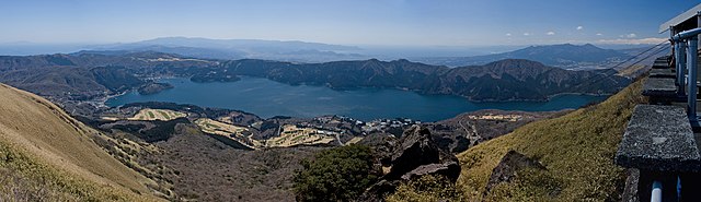
English: Lake Ashi (Ashi-no-ko) as seen from Mount Hakoene's Komagatake in Hakone, Kanagawa Prefecture, Japan. |
||||||||
| ရက်စွဲ | |||||||||
| ရင်းမြစ် | ကိုယ်ပိုင်ဖန်တီးမှု | ||||||||
| စာရေးသူ | Σ64 | ||||||||
| ခွင့်ပြုချက် (ဤဖိုင်ကို ပြန်လည်အသုံးပြုခြင်း) |
|
||||||||
| အခြား ဗားရှင်းများ |
    |

| Camera location | | View this and other nearby images on: OpenStreetMap |
|---|
ဖိုင်မှတ်တမ်း
ဖိုင်ကို ယင်းနေ့စွဲ အတိုင်း မြင်နိုင်ရန် နေ့စွဲ/အချိန် တစ်ခုခုပေါ်တွင် ကလစ်နှိပ်ပါ။
| နေ့စွဲ/အချိန် | နမူနာပုံငယ် | မှတ်တမ်း ဒိုင်မန်းရှင်းများ | အသုံးပြုသူ | မှတ်ချက် | |
|---|---|---|---|---|---|
| ကာလပေါ် | ၀၂:၅၂၊ ၃ ဧပြီ ၂၀၀၈ | ၈၈၈၉ × ၂၅၇၆ (၅ MB) | Σ64 | {{Information| |Source=Own work |Description={{ja|芦ノ湖}}{{en|Lake Ashi, Hakone, Kanagawa, Japan.}} |Author=Σ64 |Permission={{GFDL}} |Date= 2008.4.1 |other_versions= }} Category:Lake Ashi |
ဖိုင်သုံးစွဲမှု
အောက်ပါ စာမျက်နှာ သည် ဤဖိုင်ကို အသုံးပြုထားသည်:
ဂလိုဘယ် ဖိုင်သုံးစွဲမှု
အောက်ပါ အခြားဝီကီများတွင် ဤဖိုင်ကို အသုံးပြုထားသည်-
- de.wikipedia.org တွင် အသုံးပြုမှု
- en.wikipedia.org တွင် အသုံးပြုမှု
- fr.wikipedia.org တွင် အသုံးပြုမှု
- ja.wikipedia.org တွင် အသုံးပြုမှု
- ko.wikipedia.org တွင် အသုံးပြုမှု
- mn.wikipedia.org တွင် အသုံးပြုမှု
- sl.wikipedia.org တွင် အသုံးပြုမှု
- www.wikidata.org တွင် အသုံးပြုမှု
- zh.wikipedia.org တွင် အသုံးပြုမှု