
ဖိုင်:Israel location map with stripes.svg

Size of this PNG preview of this SVG file: ၃၂၂ × ၅၉၈ ပစ်ဇယ်. အခြား ပုံရိပ်ပြတ်သားမှု: ၁၂၉ × ၂၄၀ ပစ်ဇယ် | ၂၅၈ × ၄၈၀ ပစ်ဇယ် | ၄၁၃ × ၇၆၈ ပစ်ဇယ် | ၅၅၁ × ၁၀၂၄ ပစ်ဇယ် | ၁၁၀၂ × ၂၀၄၈ ပစ်ဇယ် | ၆၁၄ × ၁၁၄၁ ပစ်ဇယ်။
မူရင်းဖိုင် (SVG ဖိုင်, ၆၁၄ × ၁၁၄၁ pixels ကို အကြံပြုသည်, ဖိုင်အရွယ်အစား - ၁၇၀ KB)
| ဤဖိုင်သည် Wikimedia Commons မှဖြစ်ပြီး အခြားပရောဂျက်များတွင် သုံးကောင်းသုံးလိမ့်မည်။ ယင်း၏ ဖိုင်အကြောင်းစာမျက်နှာ တွင် ဖော်ပြထားချက်ကို အောက်တွင် ပြထားသည်။ Commons သည် မူပိုင်ခွင့်လွတ်လပ်သော မီဒီယာဖိုင်များ သိုလှောင်ထားရာ နေရာ ဖြစ်သည်။ သင်လည်း ပါဝင်ကူညီနိုင်ပါသည်။ |
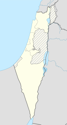
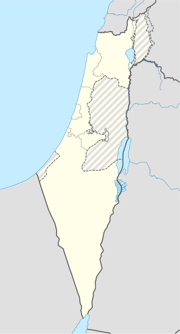
| ဖော်ပြချက် | Location map of Israel, with the Israeli-occupied Palestinian territories of the West Bank and the Gaza Strip and the Syrian Golan Heights grey stripes. | ||
| ရက်စွဲ | |||
| ရင်းမြစ် | Own work based on: Israel location map.svg by NordNordWest | ||
| စာရေးသူ | Jackmcbarn | ||
| ခွင့်ပြုချက် (ဤဖိုင်ကို ပြန်လည်အသုံးပြုခြင်း) |
ကျွန်ုပ်၊ ဤလုပ်ဆောင်ချက်၏ မူပိုင်ခွင့်ပိုင်ရှင်အနေဖြင့် ဤနေရာမှ အောက်ပါလိုင်စင်များအောက်တွင် ထုတ်လွှင့်ပါသည်:
ဤဖိုင်ကို Creative Commons Attribution-Share Alike 3.0 Unported လိုင်စင်ဖြင့် သတ်မှတ်ထားသည်။
သင်အလိုရှိရာ လိုင်စင်ကို ရွေးချယ်နိုင်ပါသည်။ |
||
| SVG genesis | ဤ SVG ၏ ကုဒ်သည် ခိုင်လုံသည်. This locator map was created with unknown tool. |

ဖိုင်မှတ်တမ်း
ဖိုင်ကို ယင်းနေ့စွဲ အတိုင်း မြင်နိုင်ရန် နေ့စွဲ/အချိန် တစ်ခုခုပေါ်တွင် ကလစ်နှိပ်ပါ။
| နေ့စွဲ/အချိန် | နမူနာပုံငယ် | မှတ်တမ်း ဒိုင်မန်းရှင်းများ | အသုံးပြုသူ | မှတ်ချက် | |
|---|---|---|---|---|---|
| ကာလပေါ် | ၁၄:၄၃၊ ၁၆ ဇွန် ၂၀၁၈ | | ၆၁၄ × ၁၁၄၁ (၁၇၀ KB) | Jdx | Reverted to version as of 10:35, 16 June 2018 (UTC) |
| ၁၄:၀၄၊ ၁၆ ဇွန် ၂၀၁၈ |  | ၅၀၄ × ၉၃၆ (၁၇၀ KB) | Beebbeebe | Reverted to version as of 00:40, 16 June 2018 (UTC) don't revert without stating a reason | |
| ၁၀:၃၅၊ ၁၆ ဇွန် ၂၀၁၈ |  | ၆၁၄ × ၁၁၄၁ (၁၇၀ KB) | Denniss | Reverted to version as of 04:28, 21 May 2018 (UTC) | |
| ၀၀:၄၀၊ ၁၆ ဇွန် ၂၀၁၈ |  | ၅၀၄ × ၉၃၆ (၁၇၀ KB) | Beebbeebe | Reverted to version as of 19:23, 14 May 2018 (UTC) The current map is simply incorrect. And I don't want to upload a new one, I'll have to edit more than a hundred wiki-articles. | |
| ၀၄:၂၈၊ ၂၁ မေ ၂၀၁၈ |  | ၆၁၄ × ၁၁၄၁ (၁၇၀ KB) | Nableezy | Reverted to version as of 19:08, 18 September 2016 (UTC) actually go back to standard no green or blue lines | |
| ၁၈:၂၃၊ ၁၅ မေ ၂၀၁၈ |  | ၆၁၄ × ၁၁၄၁ (၁၇၄ KB) | Nableezy | Reverted to version as of 03:49, 14 May 2018 (UTC) | |
| ၁၉:၂၃၊ ၁၄ မေ ၂၀၁၈ |  | ၅၀၄ × ၉၃၆ (၁၇၀ KB) | Eric's son | Reverted to version as of 13:42, 24 March 2018 (UTC) | |
| ၀၃:၄၉၊ ၁၄ မေ ၂၀၁၈ |  | ၆၁၄ × ၁၁၄၁ (၁၇၄ KB) | Nableezy | Reverted to version as of 06:09, 11 March 2018 (UTC) restore golan as occupied territory | |
| ၁၃:၄၂၊ ၂၄ မတ် ၂၀၁၈ |  | ၅၀၄ × ၉၃၆ (၁၇၀ KB) | Eric's son | Correcting color for border with Jordan | |
| ၁၃:၂၆၊ ၂၄ မတ် ၂၀၁၈ |  | ၅၀၄ × ၉၃၆ (၁၇၀ KB) | Eric's son | Fixed correct colors with vector |
ဖိုင်သုံးစွဲမှု
အောက်ပါ 4 စာမျက်နှာများ သည် ဤဖိုင်ကို အသုံးပြုထားသည်:
ဂလိုဘယ် ဖိုင်သုံးစွဲမှု
အောက်ပါ အခြားဝီကီများတွင် ဤဖိုင်ကို အသုံးပြုထားသည်-
- af.wikipedia.org တွင် အသုံးပြုမှု
- Rehovot
- Nasaret
- Eilat
- Dimona
- Ramla
- Safed
- Tiberias
- Lod
- Ben Gurion Internasionale Lughawe
- Hadera
- Gedera
- Givatayim
- Be'er Sheva
- Rishon LeZion
- Petah Tikva
- Ashdod
- Netanya
- Binyamina-Giv'at Ada
- Bnei Brak
- Holon
- Ramat Gan
- Ashkelon
- Bat Yam
- Beit Shemesh
- Kfar Saba
- Herzliya
- Modi'in-Maccabim-Re'ut
- Ra'anana
- Ramon-lughawe
- an.wikipedia.org တွင် အသုံးပြုမှု
- ar.wikipedia.org တွင် အသုံးပြုမှု
- القوات الجوية الإسرائيلية
- قلعة كوكب الهوا
- قالب:Location map Israel Golan
- قالب:Location map Israel ashkelon
- قالب:Location map Israel binyamin
- قالب:Location map Israel center ta
- قالب:Location map Israel haifa
- قالب:Location map Israel jezreel
- قالب:Location map Israel negev mt
- قالب:Location map Israel north haifa
- قالب:Location map Israel north negev
- قالب:Location map Israel northeast
- قالب:Location map Israel northwest
- قالب:Location map Israel northwest negev
- قالب:Location map Israel shomron
- قالب:Location map Israel south wb
- ثقافة كبارية
- مغارة كبارة
ဤဖိုင်ကို အခြားနေရာများတွင် အသုံးပြုထားမှုများအား ကြည့်ရှုရန်။