
ဖိုင်:IBEX all sky map.jpg

ဤနမူနာ၏ အရွယ်အစား - ၈၀၀ × ၄၅၀ ပစ်ဇယ်။ အခြား ပုံရိပ်ပြတ်သားမှု: ၃၂၀ × ၁၈၀ ပစ်ဇယ် | ၆၄၀ × ၃၆၀ ပစ်ဇယ် | ၁၀၂၄ × ၅၇၆ ပစ်ဇယ် | ၁၂၈၀ × ၇၂၀ ပစ်ဇယ် | ၂၅၆၀ × ၁၄၄၀ ပစ်ဇယ်။
မူရင်းဖိုင် (၂၅၆၀ × ၁၄၄၀ pixels, ဖိုင်အရွယ်အစား - ၅၂၃ KB, MIME အမျိုးအစား image/jpeg)
| ဤဖိုင်သည် Wikimedia Commons မှဖြစ်ပြီး အခြားပရောဂျက်များတွင် သုံးကောင်းသုံးလိမ့်မည်။ ယင်း၏ ဖိုင်အကြောင်းစာမျက်နှာ တွင် ဖော်ပြထားချက်ကို အောက်တွင် ပြထားသည်။ Commons သည် မူပိုင်ခွင့်လွတ်လပ်သော မီဒီယာဖိုင်များ သိုလှောင်ထားရာ နေရာ ဖြစ်သည်။ သင်လည်း ပါဝင်ကူညီနိုင်ပါသည်။ |
အကျဉ်းချုပ်
| ဖော်ပြချက် |
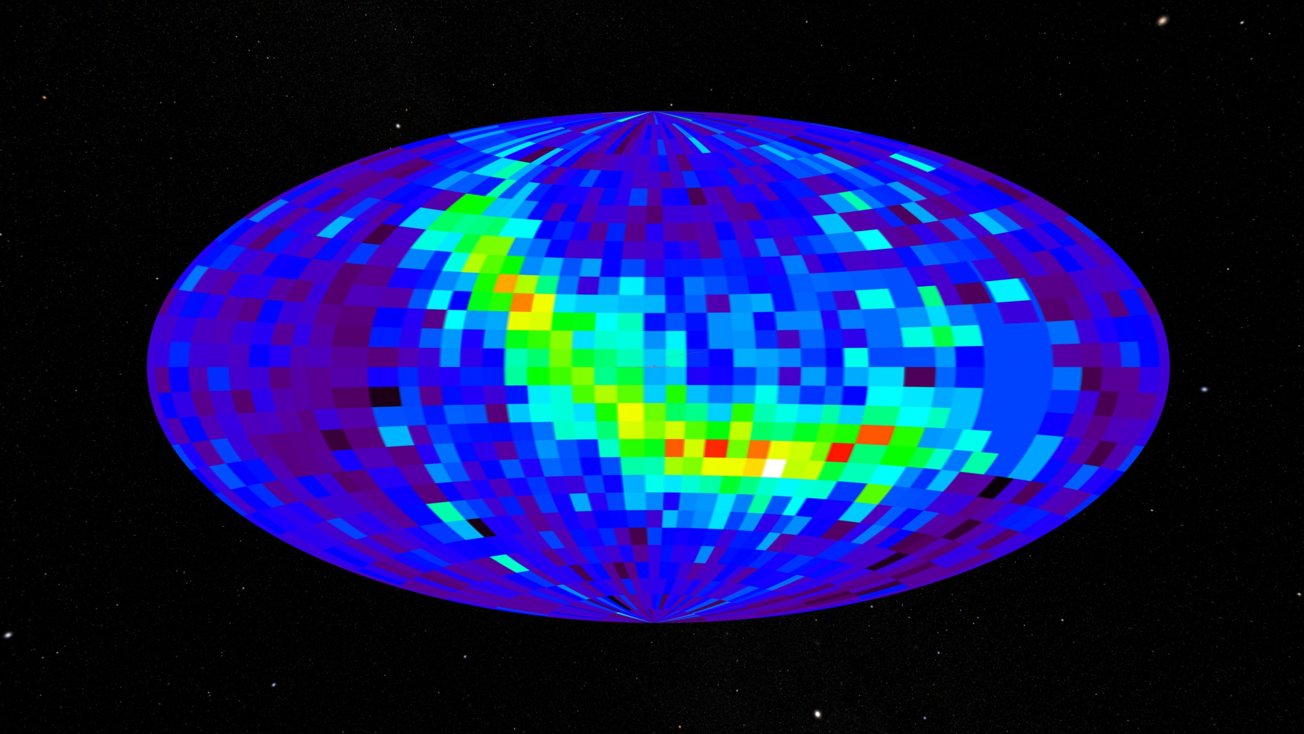
English: All-sky map created using the IBEX spacecraft. This data comes from the IBEX-Hi instrument showing differential flux at 0.9-1.5 keV. |
| ရက်စွဲ | (released) |
| ရင်းမြစ် | https://svs.gsfc.nasa.gov/3635 (image link) |
| စာရေးသူ | NASA/Goddard Space Flight Center Scientific Visualization Studio/Tom Bridgman |
လိုင်စင်သတ်မှတ်ခြင်း
| This file is in the public domain in the United States because it was solely created by NASA. NASA copyright policy states that "NASA material is not protected by copyright unless noted". (See Template:PD-USGov, NASA copyright policy page or JPL Image Use Policy.) | ||
 |
Warnings:
|
ဖိုင်မှတ်တမ်း
ဖိုင်ကို ယင်းနေ့စွဲ အတိုင်း မြင်နိုင်ရန် နေ့စွဲ/အချိန် တစ်ခုခုပေါ်တွင် ကလစ်နှိပ်ပါ။
| နေ့စွဲ/အချိန် | နမူနာပုံငယ် | မှတ်တမ်း ဒိုင်မန်းရှင်းများ | အသုံးပြုသူ | မှတ်ချက် | |
|---|---|---|---|---|---|
| ကာလပေါ် | ၀၆:၃၀၊ ၁၇ မေ ၂၀၁၈ | | ၂၅၆၀ × ၁၄၄၀ (၅၂၃ KB) | Huntster | Full resolution. |
| ၀၀:၀၅၊ ၁၇ အောက်တိုဘာ ၂၀၀၉ |  | ၃၂၀ × ၁၈၀ (၄၁ KB) | Vanished user 392817 | {{Information |Description={{en|1=All sky map created using IBEX satellite. When using please give credit to NASA/Goddard Space Flight Center Scientific Visualization Studio.}} |Source=NASA |Author=NASA/Goddard Space Flight Center Scientific Visualization |
ဖိုင်သုံးစွဲမှု
ဤဖိုင်ကို အသုံးပြုထားသော စာမျက်နှာများမရှိပါ။
ဂလိုဘယ် ဖိုင်သုံးစွဲမှု
အောက်ပါ အခြားဝီကီများတွင် ဤဖိုင်ကို အသုံးပြုထားသည်-
- ca.wikipedia.org တွင် အသုံးပြုမှု
- cs.wikipedia.org တွင် အသုံးပြုမှု
- en.wikipedia.org တွင် အသုံးပြုမှု
- en.wikinews.org တွင် အသုံးပြုမှု
- fa.wikipedia.org တွင် အသုံးပြုမှု
- fa.wikibooks.org တွင် အသုံးပြုမှု
- ja.wikipedia.org တွင် အသုံးပြုမှု
- ka.wikipedia.org တွင် အသုံးပြုမှု
- mk.wikipedia.org တွင် အသုံးပြုမှု
- ml.wikipedia.org တွင် အသုံးပြုမှု
- ms.wikipedia.org တွင် အသုံးပြုမှု
- pl.wikinews.org တွင် အသုံးပြုမှု
- pt.wikipedia.org တွင် အသုံးပြုမှု
- ro.wikipedia.org တွင် အသုံးပြုမှု
- ru.wikipedia.org တွင် အသုံးပြုမှု
- sk.wikipedia.org တွင် အသုံးပြုမှု
- sl.wikipedia.org တွင် အသုံးပြုမှု
- tr.wikipedia.org တွင် အသုံးပြုမှု
- zh.wikipedia.org တွင် အသုံးပြုမှု