ဖိုင်:Hammurabi's Babylonia 1.svg
အခြားဘာသာစကားများဖြင့် စာမျက်နှာအကြောင်းအရာများကို ပံ့ပိုးမထားပါ။
This is a file from the Wikimedia Commons
ဝီကီပီးဒီးယား မှ

မူရင်းဖိုင်(SVG ဖိုင်, ၆၅၅ × ၅၇၀ pixels ကို အကြံပြုသည်, ဖိုင်အရွယ်အစား - ၁၈၃ KB)

 
W3C-validity not checked.

အကျဉ်းချုပ်

ဖော်ပြချက်

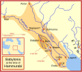
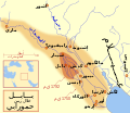
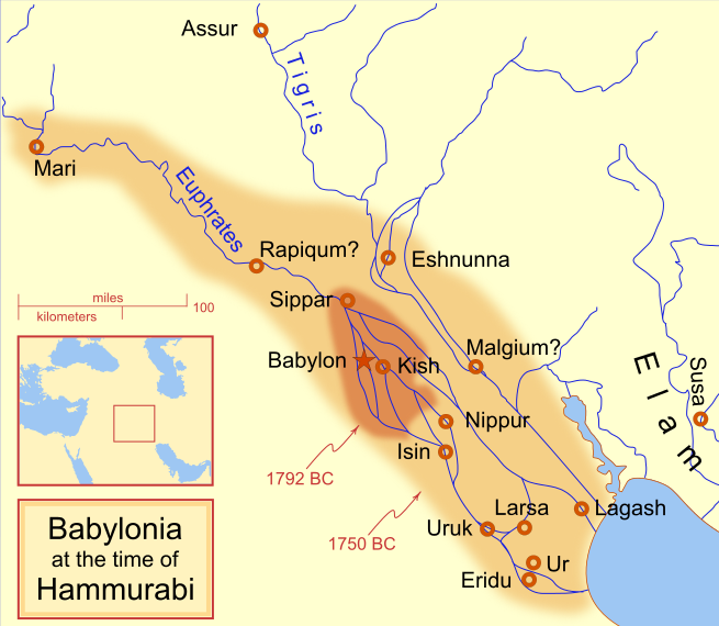
A locator map of Hammurabi's Babylonia, showing the Babylonian territory upon his ascension in 1792 BC and upon his death in 1750 BC. The river courses and coastline are those of that time period -- in general, they are not the modern rivers or coastlines. This is a Mercator projection, with north in its usual position

There is some question to what degree the cities of Nineveh, Tuttul, and Assur were under Babylonian authority. While in his introduction to his code of laws, Hammurabi claims lordship over these cities, Roaf does not include any of these in his map, upon which this map is based, and Chevalas states that "Assur and Nineveh were held for a very few years" (p. 155). Therefore, I have not included them as under Hammurabi's control in 1750 BC.
ရက်စွဲ
ရင်းမြစ် ကိုယ်ပိုင်ဖန်တီးမှု
စာရေးသူ MapMaster
အခြား ဗားရှင်းများ

[ပြင်ဆင်ရန်]

See also

References

  • Bjorklund, Oddvar; Holmboe, Haakon; Rohr, Anders (1970) Historical Atlas of the World, Barnes & Noble, NY, SBN: 389-00253-4.
  • Chavalas, Mark W.; K. Lawson Younger (2003) Mesopotamia and the Bible, Continuum International Publishing Group, ISBN 978-0567082312.
  • Hammond World Atlas Corporation (2007) Historical World Atlas, ISBN 9-780843-71391-6
  • Roaf, M. (1990) Cultural Atlas of Mesopotamia and the ancient Near East, Oxford: Facts on File. (In general, the basis for the ancient river courses and ancient coastline).
  • Van De Mieroop, Marc (2005). King Hammurabi of Babylon: A Biography. Blackwell Publishing. ISBN 1405126604

လိုင်စင်သတ်မှတ်ခြင်း

ကျွန်ုပ်၊ ဤလုပ်ဆောင်ချက်၏ မူပိုင်ခွင့်ပိုင်ရှင်အနေဖြင့် ဤနေရာမှ အောက်ပါလိုင်စင်များအောက်တွင် ထုတ်လွှင့်ပါသည်:
GNU head ဤစာတမ်းကို GNU Free Documentation License, ဗားရှင်း ၁.၂ သို့မဟုတ် Free Software Foundation မှ ဖြန့်ချီထားသော မည်သည့်ယခင်ဗားရှင်းတစ်ခုခုအောက်တွင် Invariant Sections, Front-Cover Texts နှင့် Back-Cover Texts များမပါဝင်ဘဲ ကူးယူခြင်း၊ ဖြန့်ချီခြင်း နှင့်/သို့မဟုတ် ပြင်ဆင်ပြောင်းလဲနိုင်ရန် ခွင့်ပြုသည်။ လိုင်စင်မူပွားကို GNU Free Documentation License ခေါင်းစဉ်အောက်တွင် ထည့်သွင်းထားသည်။
w:my:Creative Commons
မှတ်ယူနိုင်ခြင်း ထပ်တူမျှဝေ
This file is licensed under the Creative Commons Attribution-Share Alike 4.0 International, 3.0 Unported, 2.5 Generic, 2.0 Generic and 1.0 Generic license.
သင်သည် လွတ်လပ်စွာ:
  • မျှဝေရန် – ဖန်တီးမှုကို ကူးယူရန်၊ ဖြန့်ဖြူးရန်နှင့် ထုတ်လွှင့်ရန်
  • ပြန်ရောနှောရန် – ဖန်တီးမှုကို ပြင်ဆင်ညှိနှိုင်းရန်
အောက်ပါ အခြေအနေများတွင်:
  • မှတ်ယူနိုင်ခြင်း – ပြောင်းလဲမှုများ ပြုလုပ်ခဲ့ပါက ဖန်တီးသူ သို့မဟုတ် လိုင်စင်ရှိသူမှ သတ်မှတ်သော အမျိုးအစားကို လိုက်နာရမည် (ဆိုလိုသည်မှာ သင့်အား သို့မဟုတ် သင့်ဖန်တီးမှုတွင် အသုံးပြုခြင်းအား ထောက်ခံချက်ပေးသည်ဟု မဆိုလိုပါ)။
  • ထပ်တူမျှဝေ – ဤဖန်တီးမှုအား ပြင်ဆင်ခြင်း၊ ပြောင်းလဲခြင်း သို့မဟုတ် ထပ်ဆင့် ဖန်တီးခြင်း ပြုလုပ်ပါက ရရှိလာသော ဖန်တီးမှုကို ဤဖန်တီးမှုနှင့် သို့မဟုတ် ဆင်တူသော လိုင်စင်ဖြင့်သာ ဖြန့်ချိသင့်သည်။
သင်အလိုရှိရာ လိုင်စင်ကို ရွေးချယ်နိုင်ပါသည်။

ပုံစာများ

ဤဖိုင်၏ဆိုလိုရင်းကို စာတစ်ကြောင်းရှင်းလင်းချက်ဖြင့် ထည့်သွင်းရန်
Babylonian

Items portrayed in this file

depicts အင်္ဂလိပ်

some value

Wikimedia username အင်္ဂလိပ်: MapMaster
object has role အင်္ဂလိပ်: photographer အင်္ဂလိပ်
author name string အင်္ဂလိပ်: MapMaster

၁၈ ဖေဖော်ဝါရီ 2008

MIME type အင်္ဂလိပ်

image/svg+xml

ဖိုင်မှတ်တမ်း

ဖိုင်ကို ယင်းနေ့စွဲ အတိုင်း မြင်နိုင်ရန် နေ့စွဲ/အချိန် တစ်ခုခုပေါ်တွင် ကလစ်နှိပ်ပါ။

(အသစ်ဆုံး | အဟောင်းဆုံး) (ပိုသစ်သော ၁၀ ခု | ) အထိကြား ရလဒ် (၁၀ | ၂၀ | ၅၀ | ၁၀၀ | ၂၅၀ | ၅၀၀) ခုကို ကြည့်ရန်
နေ့စွဲ/အချိန်နမူနာပုံငယ်မှတ်တမ်း ဒိုင်မန်းရှင်းများအသုံးပြုသူမှတ်ချက်
ကာလပေါ် ၀၉:၁၄၊ ၂၁ ဧပြီ ၂၀၁၃ ၀၉:၁၄၊ ၂၁ ဧပြီ ၂၀၁၃ ရက်က မူအတွက် နမူနာပုံငယ်၆၅၅ × ၅၇၀ (၁၈၃ KB)CitypeekCleanup of file. Valid SVG now.
၁၉:၀၆၊ ၂၇ ဧပြီ ၂၀၁၀ ၁၉:၀၆၊ ၂၇ ဧပြီ ၂၀၁၀ ရက်က မူအတွက် နမူနာပုံငယ်၆၅၅ × ၅၇၀ (၁၆၈ KB)DieBucheremoved border
၁၅:၀၅၊ ၃၀ ဇူလိုင် ၂၀၀၉ ၁၅:၀၅၊ ၃၀ ဇူလိုင် ၂၀၀၉ ရက်က မူအတွက် နမူနာပုံငယ်၆၆၁ × ၅၈၀ (၃၁၇ KB)Amit6Some nodes changed.
၂၃:၂၄၊ ၃ မတ် ၂၀၀၈ ၂၃:၂၄၊ ၃ မတ် ၂၀၀၈ ရက်က မူအတွက် နမူနာပုံငယ်၆၆၁ × ၅၈၀ (၁၆၃ KB)MapMasterAdded city-state, moved Sippar, minor other changes based on recent Kassite map
၁၆:၀၆၊ ၂၃ ဖေဖော်ဝါရီ ၂၀၀၈ ၁၆:၀၆၊ ၂၃ ဖေဖော်ဝါရီ ၂၀၀၈ ရက်က မူအတွက် နမူနာပုံငယ်၆၆၁ × ၅၈၀ (၁၆၁ KB)MapMasterAdded 1 city, added name for 1 city
၀၃:၂၉၊ ၂၁ ဖေဖော်ဝါရီ ၂၀၀၈ ၀၃:၂၉၊ ၂၁ ဖေဖော်ဝါရီ ၂၀၀၈ ရက်က မူအတွက် နမူနာပုံငယ်၆၆၁ × ၅၈၀ (၁၅၉ KB)MapMaster"blurred" the territory outlines
၂၃:၂၅၊ ၂၀ ဖေဖော်ဝါရီ ၂၀၀၈ ၂၃:၂၅၊ ၂၀ ဖေဖော်ဝါရီ ၂၀၀၈ ရက်က မူအတွက် နမူနာပုံငယ်၆၆၁ × ၅၈၀ (၁၅၅ KB)MapMasterChanges made based on info from ''Mesopotamia and the Bible''
၀၂:၀၃၊ ၁၉ ဖေဖော်ဝါရီ ၂၀၀၈ ၀၂:၀၃၊ ၁၉ ဖေဖော်ဝါရီ ၂၀၀၈ ရက်က မူအတွက် နမူနာပုံငယ်၆၆၃ × ၅၈၀ (၁၅၆ KB)MapMasterFixed an error on my part
၂၁:၁၂၊ ၁၈ ဖေဖော်ဝါရီ ၂၀၀၈ ၂၁:၁၂၊ ၁၈ ဖေဖော်ဝါရီ ၂၀၀၈ ရက်က မူအတွက် နမူနာပုံငယ်၃၃၂ × ၂၉၂ (၁၅၆ KB)MapMastersome minor edits
၁၉:၁၉၊ ၁၈ ဖေဖော်ဝါရီ ၂၀၀၈ ၁၉:၁၉၊ ၁၈ ဖေဖော်ဝါရီ ၂၀၀၈ ရက်က မူအတွက် နမူနာပုံငယ်၃၃၂ × ၂၉၃ (၁၅၄ KB)MapMasterremoved unrenderable bmp
(အသစ်ဆုံး | အဟောင်းဆုံး) (ပိုသစ်သော ၁၀ ခု | ) အထိကြား ရလဒ် (၁၀ | ၂၀ | ၅၀ | ၁၀၀ | ၂၅၀ | ၅၀၀) ခုကို ကြည့်ရန်

အောက်ပါ စာမျက်နှာ သည် ဤဖိုင်ကို အသုံးပြုထားသည်:

ဂလိုဘယ် ဖိုင်သုံးစွဲမှု

အောက်ပါ အခြားဝီကီများတွင် ဤဖိုင်ကို အသုံးပြုထားသည်-

ဤဖိုင်ကို အခြားနေရာများတွင် အသုံးပြုထားမှုများအား ကြည့်ရှုရန်။

မီတာဒေတာ