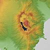
ဖိုင်:Hakone Volcano 3D. Relief Map(b). SRTM-1 Ver3.jpg

အခြားဘာသာစကားများဖြင့် စာမျက်နှာအကြောင်းအရာများကို ပံ့ပိုးမထားပါ။
This is a file from the Wikimedia Commons
ဝီကီပီးဒီးယား မှ

မူရင်းဖိုင်(၁၈၀၀ × ၁၈၀၀ pixels, ဖိုင်အရွယ်အစား - ၁.၇၁ MB, MIME အမျိုးအစား image/jpeg)

အကျဉ်းချုပ်

ဖော်ပြချက်
English: Hakone Volcano in Kanagawa Prefecture, Honshu, Japan. This file updated by 30m Mesh.
日本語: 神奈川県箱根山。 このファイルは30mメッシュでアップデートしました。
ရက်စွဲ
ရင်းမြစ်

Topographic data: NASA's SRTM-1 30m Mesh (ver.3 2014)

Rendering software: KASHMIR 3D
စာရေးသူ Batholith
အခြား ဗားရှင်းများ
Object location၃၅° ၁၄′ ၀၀″ N, ၁၃၉° ၀၂′ ၀၀″ E Kartographer map based on OpenStreetMap.View this and other nearby images on: OpenStreetMapinfo

လိုင်စင်သတ်မှတ်ခြင်း

Public domain I, the copyright holder of this work, release this work into the public domain. This applies worldwide.
In some countries this may not be legally possible; if so:
အကျွန်ုပ်သည် ဤဖန်တီးမှုလက်ရာကို ဥပဒေအရလိုအပ်ခြင်းမရှိသည့် မည်သည့်အခြေအနေမျိုးတွက်မဆို၊ မည်သို့သော ရည်ရွယ်ချက်အတွက်မဆို ၎င်းကို မည်သူမဆို အသုံးပြုပိုင်ခွင့်အား ပေးအပ်သည်။
Public domain
Public domain
This image uses high-resolution digital topography data from NASA's Shuttle Radar Topography Mission (SRTM) at JPL-Caltech [1]. It is in the public domain in the United States.

NASA shuttle
NASA shuttle
English | Bahasa Indonesia | македонски | polski | português | 中文 | 中文(简体)‎ | +/−

ပုံစာများ

ဤဖိုင်၏ဆိုလိုရင်းကို စာတစ်ကြောင်းရှင်းလင်းချက်ဖြင့် ထည့်သွင်းရန်

Items portrayed in this file

depicts အင်္ဂလိပ်

၂၇ ဖေဖော်ဝါရီ 2016

coordinates of depicted place အင်္ဂလိပ်

35°13'59.999"N, 139°1'59.999"E

media type အင်္ဂလိပ်

image/jpeg

ဖိုင်မှတ်တမ်း

ဖိုင်ကို ယင်းနေ့စွဲ အတိုင်း မြင်နိုင်ရန် နေ့စွဲ/အချိန် တစ်ခုခုပေါ်တွင် ကလစ်နှိပ်ပါ။

နေ့စွဲ/အချိန်နမူနာပုံငယ်မှတ်တမ်း ဒိုင်မန်းရှင်းများအသုံးပြုသူမှတ်ချက်
ကာလပေါ် ၁၃:၂၄၊ ၂၇ ဖေဖော်ဝါရီ ၂၀၁၆ ၁၃:၂၄၊ ၂၇ ဖေဖော်ဝါရီ ၂၀၁၆ ရက်က မူအတွက် နမူနာပုံငယ်၁၈၀၀ × ၁၈၀၀ (၁.၇၁ MB)Batholith{{Information |Description= {{en|Hakone volcano Relief Map, Japan. A Data of "SRTM-1 Ver.3 2014". }} {{ja|箱根山の地形図。 [[:ja:Shuttle Radar Topography Mission...

အောက်ပါ စာမျက်နှာ သည် ဤဖိုင်ကို အသုံးပြုထားသည်:

ဂလိုဘယ် ဖိုင်သုံးစွဲမှု

အောက်ပါ အခြားဝီကီများတွင် ဤဖိုင်ကို အသုံးပြုထားသည်-

မီတာဒေတာ