ဖိုင်:Germany occupation zones with border.jpg
အခြားဘာသာစကားများဖြင့် စာမျက်နှာအကြောင်းအရာများကို ပံ့ပိုးမထားပါ။
This is a file from the Wikimedia Commons
ဝီကီပီးဒီးယား မှ

မူရင်းဖိုင်(၁၄၆၀ × ၁၂၁၂ pixels, ဖိုင်အရွယ်အစား - ၈၆၁ KB, MIME အမျိုးအစား image/jpeg)

This map image could be re-created using vector graphics as an SVG file. This has several advantages; see Commons:Media for cleanup for more information. If an SVG form of this image is available, please upload it and afterwards replace this template with {{vector version available|new image name}}.


It is recommended to name the SVG file “Germany occupation zones with border.svg”—then the template Vector version available (or Vva) does not need the new image name parameter.

အကျဉ်းချုပ်

ဖော်ပြချက်
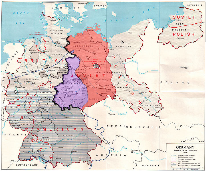
English: Map of the occupation zones of Germany in 1945, modified to show the inner German border and the zone from which Allied forces withdrew in July 1945. From Earl F. Ziemke, The U.S. Army in the Occupation of Germany, 1975. Library of Congress, Catalog Card Number 75-619027.


Explanation taken from w:Inner_German_border: The Allied zones of occupation in post-war Germany, highlighting the Soviet zone (red), the inner German border (heavy black line) and the zone from which British and American troops withdrew in July 1945 (purple). The provincial boundaries are those of pre-Nazi Weimar Germany, before the present Länder (federal states) were established.


Deutsch: Karte der Besatzungszonen in Deutschland im Jahr 1945. Sie wurde modifiziert, um die innerdeutsche Grenze und die Zone, aus der sich die Alliierten im Juli 1945 zurückzogen, zu verdeutlichen. Von Earl F. Ziemke, Die US-Armee während der Besetzung Deutschlands, 1975. Kongress-Bibliothek, Katalog-Karten-Nummer 75-619027.


Erläuterung entnommen aus w:Inner_German_border: Die alliierten Besatzungszonen im Nachkriegsdeutschland. Hervorgehoben sind die sowjetische Zone (rot), die spätere innerdeutsche Grenze (dicke schwarze Linie) und der Bereich, aus dem sich die amerikanischen Truppen im Juli 1945 zurückzogen (lila). Nicht eingetragen ist die Linie, von der sich die britischen Truppen zurückzogen. Sie verlief östlich von Wismar und Schwerin bis zur Elbe. Die Provinzgrenzen entsprechen denen der Weimarer Republik vor der Gründung der heutigen Bundesländer.


Français : Carte des zones d'occupation de l'Allemagne en 1945, modifié pour montrer la frontière allemande intérieure et la zone d'où les forces alliées se retirèrent en Juillet 1945. De Earl F. Ziemke, l'armée américaine dans l'occupation de l'Allemagne, 1975. Bibliothèque du Congrès, Catalogue Numéro de la carte 75-619027.


Русский: Карта, показывающая зоны оккупации послевоенной Германии, а также линию продвижения американских войск на день капитуляции. Юго-западная часть советской зоны оккупации, около трети её общей площади, находилась западней американских позиций на день капитуляции. Советская зона выделена красным, а область, из которой были отведены в июле 1945 года британские и американские войска — фиолетовым, внутригерманская граница показана жирной чёрной линией. Границы областей показаны в соответствии с территориальным делением Веймарской республики, до современного федерального деления на земли.
ရက်စွဲ
ရင်းမြစ် Modified version of http://www.globalsecurity.org/military/library/report/other/us-army_germany_1944-46_map3.htm
စာရေးသူ US Army
အခြား ဗားရှင်းများ
This historical map image could be re-created using vector graphics as an SVG file. This has several advantages; see Commons:Media for cleanup for more information. If an SVG form of this image is available, please upload it and afterwards replace this template with {{vector version available|new image name}}.


It is recommended to name the SVG file “Germany occupation zones with border.svg”—then the template Vector version available (or Vva) does not need the new image name parameter.

လိုင်စင်သတ်မှတ်ခြင်း

Public domain
ဤဖိုင်သည် အမေရိကန်ပြည်​ထောင်စု(ကြည်း)တပ်မတော်တွင် တာဝန်ထမ်းဆောင်နေသူ တပ်မတော်သား (သို့) ဝန်ထမ်းတစ်ဦး၏ လုပ်ငန်းတာဝန်နှင့်သက်ဆိုင်ပြီး ထိုပုဂ္ဂိုလ်၏ တရားဝင်တာဝန်များထဲ၌ တစိတ်တ​ဒေသအဖြစ် ပါဝင်ပတ်သက်နေသောအရာဖြစ်သည်။ အ​မေရိကန်ပြည်​ထောင်စု၏ အစိုးရလုပ်ငန်းတစ်ခုအနေဖြင့် ဖက်ဒရယ်အစိုးရ၏သတ်မှတ်မှုအရ ၎င်းသည် အမေရိကန်ပြည်ထောင်စု၌ အများပြည်သူပိုင် သည့် အရာအဖြစ်အကျုံးဝင်သည်။

العربية  বাংলা  català  čeština  Deutsch  English  español  eesti  فارسی  suomi  français  hrvatski  magyar  Bahasa Indonesia  italiano  日本語  한국어  lietuvių  македонски  മലയാളം  မြန်မာဘာသာ  Nederlands  polski  português  русский  sicilianu  српски / srpski  Türkçe  українська  Tiếng Việt  中文(简体)  中文(繁體)  +/−

ပုံစာများ

ဤဖိုင်၏ဆိုလိုရင်းကို စာတစ်ကြောင်းရှင်းလင်းချက်ဖြင့် ထည့်သွင်းရန်

Items portrayed in this file

depicts အင်္ဂလိပ်

ဖိုင်မှတ်တမ်း

ဖိုင်ကို ယင်းနေ့စွဲ အတိုင်း မြင်နိုင်ရန် နေ့စွဲ/အချိန် တစ်ခုခုပေါ်တွင် ကလစ်နှိပ်ပါ။

နေ့စွဲ/အချိန်နမူနာပုံငယ်မှတ်တမ်း ဒိုင်မန်းရှင်းများအသုံးပြုသူမှတ်ချက်
ကာလပေါ် ၂၃:၅၂၊ ၂၄ စက်တင်ဘာ ၂၀၀၉ ၂၃:၅၂၊ ၂၄ စက်တင်ဘာ ၂၀၀၉ ရက်က မူအတွက် နမူနာပုံငယ်၁၄၆၀ × ၁၂၁၂ (၈၆၁ KB)ChrisOFixed errors
၁၆:၅၇၊ ၁၉ စက်တင်ဘာ ၂၀၀၉ ၁၆:၅၇၊ ၁၉ စက်တင်ဘာ ၂၀၀၉ ရက်က မူအတွက် နမူနာပုံငယ်၁၄၆၀ × ၁၂၁၂ (၈၆၃ KB)ChrisO{{Information |Description={{en|1=Map of the occupation zones of Germany in 1945, modified to show the inner German border and the zone from which Allied forces withdrew in July 1945. From Earl F. Ziemke, ''The U.S. Army in the Occupation of Germany'', 19

အောက်ပါ စာမျက်နှာ သည် ဤဖိုင်ကို အသုံးပြုထားသည်:

ဂလိုဘယ် ဖိုင်သုံးစွဲမှု

အောက်ပါ အခြားဝီကီများတွင် ဤဖိုင်ကို အသုံးပြုထားသည်-

ဤဖိုင်ကို အခြားနေရာများတွင် အသုံးပြုထားမှုများအား ကြည့်ရှုရန်။

မီတာဒေတာ