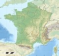
ဖိုင်:France relief location map.jpg

ဤနမူနာ၏ အရွယ်အစား - ၆၂၄ × ၆၀၀ ပစ်ဇယ်။ အခြား ပုံရိပ်ပြတ်သားမှု: ၂၅၀ × ၂၄၀ ပစ်ဇယ် | ၄၉၉ × ၄၈၀ ပစ်ဇယ် | ၇၉၉ × ၇၆၈ ပစ်ဇယ် | ၁၀၆၆ × ၁၀၂၄ ပစ်ဇယ် | ၂၀၀၀ × ၁၉၂၂ ပစ်ဇယ်။
မူရင်းဖိုင် (၂၀၀၀ × ၁၉၂၂ pixels, ဖိုင်အရွယ်အစား - ၉၀၇ KB, MIME အမျိုးအစား image/jpeg)
ဖိုင်မှတ်တမ်း
ဖိုင်ကို ယင်းနေ့စွဲ အတိုင်း မြင်နိုင်ရန် နေ့စွဲ/အချိန် တစ်ခုခုပေါ်တွင် ကလစ်နှိပ်ပါ။
| နေ့စွဲ/အချိန် | နမူနာပုံငယ် | မှတ်တမ်း ဒိုင်မန်းရှင်းများ | အသုံးပြုသူ | မှတ်ချက် | |
|---|---|---|---|---|---|
| ကာလပေါ် | ၁၅:၀၁၊ ၁၉ အောက်တိုဘာ ၂၀၁၇ |  | ၂၀၀၀ × ၁၉၂၂ (၉၀၇ KB) | Sting | No borders over the Lake of Constance |
| ၀၈:၄၄၊ ၃ ဇန်နဝါရီ ၂၀၁၆ |  | ၂၀၀၀ × ၁၉၂၂ (၈၈၈ KB) | Jack ma | updated new administrative region boundaries 1/1/2016 | |
| ၁၂:၃၁၊ ၂ အောက်တိုဘာ ၂၀၁၂ |  | ၂၀၀၀ × ၁၉၂၂ (၈၁၄ KB) | Palosirkka | Reverted to version as of 22:20, 17 July 2010 Location maps must remain very accurate | |
| ၀၉:၁၄၊ ၂ အောက်တိုဘာ ၂၀၁၂ |  | ၂၀၀၀ × ၁၉၂၂ (၇၉၇ KB) | Palosirkka | Optimized with http://trimage.org | |
| ၂၂:၂၀၊ ၁၇ ဇူလိုင် ၂၀၁၀ |  | ၂၀၀၀ × ၁၉၂၂ (၈၁၄ KB) | Sting | Color profile | |
| ၁၄:၁၅၊ ၁၇ နိုဝင်ဘာ ၂၀၀၉ |  | ၂၀၀၀ × ၁၉၂၂ (၈၂၂ KB) | Sting | Embedded sRGB profile | |
| ၁၃:၂၉၊ ၇ နိုဝင်ဘာ ၂၀၀၈ |  | ၂၀၀၀ × ၁၉၂၂ (၈၀၁ KB) | Sting | + boundary for Channel Islands ; - canals | |
| ၁၆:၄၁၊ ၂၃ ဩဂုတ် ၂၀၀၈ |  | ၂၀၀၀ × ၁၉၂၂ (၈၀၃ KB) | Sting | Larger strokes for boundaries | |
| ၁၇:၅၈၊ ၂၅ ဇူလိုင် ၂၀၀၈ |  | ၂၀၀၀ × ၁၉၂၂ (၈၁၅ KB) | Sting | Variable scale | |
| ၁၄:၄၆၊ ၂၅ ဇူလိုင် ၂၀၀၈ |  | ၂၀၀၀ × ၁၉၂၂ (၈၁၄ KB) | Sting | - border |
ဖိုင်သုံးစွဲမှု
အောက်ပါ 3 စာမျက်နှာများ သည် ဤဖိုင်ကို အသုံးပြုထားသည်:
ဂလိုဘယ် ဖိုင်သုံးစွဲမှု
အောက်ပါ အခြားဝီကီများတွင် ဤဖိုင်ကို အသုံးပြုထားသည်-
- als.wikipedia.org တွင် အသုံးပြုမှု
- Grosser Belchen
- Donon
- Vorlage:Positionskarte Frankreich
- Planche des Belles Filles
- Vorlage:Positionskarte Frankreich Haut-Rhin
- Vorlage:Positionskarte Frankreich Bas-Rhin
- Vorlage:Positionskarte Frankreich Saône-et-Loire
- Vorlage:Positionskarte Frankreich Paris
- Vorlage:Positionskarte Frankreich Territoire de Belfort
- Vorlage:Positionskarte Frankreich Essonne
- Vorlage:Positionskarte Frankreich Pyrénées-Orientales
- Vorlage:Positionskarte Frankreich Pas-de-Calais
- Vorlage:Positionskarte Frankreich Normandie
- Vorlage:Positionskarte Frankreich Orne
- Vorlage:Positionskarte Frankreich Île-de-France
- Vorlage:Positionskarte Frankreich Nord
- Vorlage:Positionskarte Frankreich Moselle
- Vorlage:Positionskarte Frankreich Morbihan
- Vorlage:Positionskarte Frankreich Maine-et-Loire
- Vorlage:Positionskarte Frankreich Pays de la Loire
- Vorlage:Positionskarte Frankreich Loire-Atlantique
- Vorlage:Positionskarte Frankreich Isère
- Vorlage:Positionskarte Frankreich Ille-et-Vilaine
- Vorlage:Positionskarte Frankreich Okzitanien
- Vorlage:Positionskarte Frankreich Gard
- Vorlage:Positionskarte Frankreich Korsika
- Vorlage:Positionskarte Frankreich Corse-du-Sud
- Vorlage:Positionskarte Frankreich Nouvelle-Aquitaine
- Vorlage:Positionskarte Frankreich Dordogne
- Vorlage:Positionskarte Frankreich Bretagne
- Vorlage:Positionskarte Frankreich Finistère
- Vorlage:Positionskarte Frankreich Côtes-d’Armor
- Vorlage:Positionskarte Frankreich Bourgogne-Franche-Comté
- Vorlage:Positionskarte Frankreich Alpes-Maritimes
- Vorlage:Positionskarte Frankreich Provence-Alpes-Côte d’Azur
- Vorlage:Positionskarte Frankreich Alpes-de-Haute-Provence
- Vorlage:Positionskarte Frankreich Allier
- Vorlage:Positionskarte Frankreich Hauts-de-France
- Vorlage:Positionskarte Frankreich Aisne
- Vorlage:Positionskarte Frankreich Auvergne-Rhône-Alpes
- Vorlage:Positionskarte Frankreich Ain
- Vorlage:Positionskarte Frankreich Grand Est
- Vorlage:Positionskarte Frankreich Ardèche
- Vorlage:Positionskarte Frankreich Calvados
- Vorlage:Positionskarte Frankreich Cantal
- Vorlage:Positionskarte Frankreich Charente
- Vorlage:Positionskarte Frankreich Centre-Val de Loire
- Vorlage:Positionskarte Frankreich Charente-Maritime
- Vorlage:Positionskarte Frankreich Haute-Corse
- Vorlage:Positionskarte Frankreich Eure
ဤဖိုင်ကို အခြားနေရာများတွင် အသုံးပြုထားမှုများအား ကြည့်ရှုရန်။


