
ဖိုင်:Europe location.png

ဤနမူနာ၏ အရွယ်အစား - ၈၀၀ × ၆၀၀ ပစ်ဇယ်။ အခြား ပုံရိပ်ပြတ်သားမှု: ၃၂၀ × ၂၄၀ ပစ်ဇယ် | ၆၄၀ × ၄၈၀ ပစ်ဇယ် | ၁၀၂၄ × ၇၆၈ ပစ်ဇယ် | ၁၂၈၀ × ၉၆၀ ပစ်ဇယ် | ၁၆၀၀ × ၁၂၀၀ ပစ်ဇယ်။
မူရင်းဖိုင် (၁၆၀၀ × ၁၂၀၀ pixels, ဖိုင်အရွယ်အစား - ၄၂၀ KB, MIME အမျိုးအစား image/png)
| ဤဖိုင်သည် Wikimedia Commons မှဖြစ်ပြီး အခြားပရောဂျက်များတွင် သုံးကောင်းသုံးလိမ့်မည်။ ယင်း၏ ဖိုင်အကြောင်းစာမျက်နှာ တွင် ဖော်ပြထားချက်ကို အောက်တွင် ပြထားသည်။ Commons သည် မူပိုင်ခွင့်လွတ်လပ်သော မီဒီယာဖိုင်များ သိုလှောင်ထားရာ နေရာ ဖြစ်သည်။ သင်လည်း ပါဝင်ကူညီနိုင်ပါသည်။ |

|
This locator map image could be re-created using vector graphics as an SVG file. This has several advantages; see Commons:Media for cleanup for more information. If an SVG form of this image is available, please upload it and afterwards replace this template with
{{vector version available|new image name}}.
It is recommended to name the SVG file “Europe location.svg”—then the template Vector version available (or Vva) does not need the new image name parameter. |
| ဖော်ပြချက် |
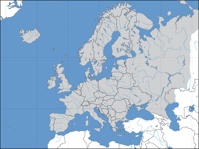
Deutsch: Politische Karte des Kontinents Europa. Leere Lagekarte zur Darstellung der Lage von Staaten in Europa. Europa ist grau hervorgehoben. |
||||||||
| ရက်စွဲ | 02.09.2006 | ||||||||
| ရင်းမြစ် | ကိုယ်ပိုင်ဖန်တီးမှု | ||||||||
| စာရေးသူ | David Liuzzo | ||||||||
| ခွင့်ပြုချက် (ဤဖိုင်ကို ပြန်လည်အသုံးပြုခြင်း) |
ကျွန်ုပ်၊ ဤလုပ်ဆောင်ချက်၏ မူပိုင်ခွင့်ပိုင်ရှင်အနေဖြင့် ဤနေရာမှ အောက်ပါလိုင်စင်များအောက်တွင် ထုတ်လွှင့်ပါသည်:
ဤဖိုင်သည် Creative Commons Attribution-Share Alike 2.0 ဂျာမနီ လိုင်စင်အောက်တွင် လိုင်စင်သတ်မှတ်ထားပါသည်။
 သင်အလိုရှိရာ လိုင်စင်ကို ရွေးချယ်နိုင်ပါသည်။ |
||||||||
| အခြား ဗားရှင်းများ | Derivative works of this file: Convoy Faith route July 1943.png |

| Annotations | This image is annotated: View the annotations at Commons |
ဖိုင်မှတ်တမ်း
ဖိုင်ကို ယင်းနေ့စွဲ အတိုင်း မြင်နိုင်ရန် နေ့စွဲ/အချိန် တစ်ခုခုပေါ်တွင် ကလစ်နှိပ်ပါ။
| နေ့စွဲ/အချိန် | နမူနာပုံငယ် | မှတ်တမ်း ဒိုင်မန်းရှင်းများ | အသုံးပြုသူ | မှတ်ချက် | |
|---|---|---|---|---|---|
| ကာလပေါ် | ၁၂:၄၀၊ ၈ ဩဂုတ် ၂၀၂၂ | | ၁၆၀၀ × ၁၂၀၀ (၄၂၀ KB) | Рагин1987 | More correct visualization of the dividing line on the territory of the Caucasus Range |
| ၁၅:၅၀၊ ၃၁ မေ ၂၀၁၅ |  | ၁၆၀၀ × ၁၂၀၀ (၂၂၃ KB) | Cmdrjameson | Compressed with pngout. Reduced by 101kB (31% decrease). | |
| ၂၀:၃၉၊ ၂၁ ဇူလိုင် ၂၀၀၈ |  | ၁၆၀၀ × ၁၂၀၀ (၃၂၅ KB) | ShakataGaNai | Reverted to version as of 23:32, 9 May 2008 | |
| ၁၄:၅၂၊ ၂၁ ဇူလိုင် ၂၀၀၈ |  | ၁၆၀၀ × ၁၂၀၀ (၃၂၃ KB) | European Boy~commonswiki | {{Information |Description= |Source= |Date= |Author= |Permission= |other_versions= }} | |
| ၂၃:၃၂၊ ၉ မေ ၂၀၀၈ |  | ၁၆၀၀ × ၁၂၀၀ (၃၂၅ KB) | Solestin~commonswiki | correction of Ural border | |
| ၂၀:၅၉၊ ၁၇ အောက်တိုဘာ ၂၀၀၆ |  | ၁၆၀၀ × ၁၂၀၀ (၄၄၄ KB) | David Liuzzo | Correction; Same licensing applies. | |
| ၂၃:၀၀၊ ၃ စက်တင်ဘာ ၂၀၀၆ |  | ၁၆၀၀ × ၁၂၀၀ (၁၀၈ KB) | David Liuzzo | {{Information| |Description={{de|Politische Karte des Kontinents Europa. Leere Lagekarte zur Darstellung der Lage von Staaten in Europa. Europa ist grau hervorgehoben.}} |Source= Own Work |Date= 02.09.2006 |Author= David Liuzzo |Perm |
ဖိုင်သုံးစွဲမှု
ဤဖိုင်ကို အသုံးပြုထားသော စာမျက်နှာများမရှိပါ။
ဂလိုဘယ် ဖိုင်သုံးစွဲမှု
အောက်ပါ အခြားဝီကီများတွင် ဤဖိုင်ကို အသုံးပြုထားသည်-
- af.wikipedia.org တွင် အသုံးပြုမှု
- ary.wikipedia.org တွင် အသုံးပြုမှု
- az.wikipedia.org တွင် အသုံးပြုမှု
- be-tarask.wikipedia.org တွင် အသုံးပြုမှု
- be.wikipedia.org တွင် အသုံးပြုမှု
- bn.wikipedia.org တွင် အသုံးပြုမှု
- cv.wikipedia.org တွင် အသုံးပြုမှု
- de.wikipedia.org တွင် အသုံးပြုမှု
- Volleyball-Europameisterschaft der Frauen 2005
- Benutzer:JagielloXXwieku
- Volleyball-Europameisterschaft der Männer 2005
- Volleyball-Europameisterschaft
- Vorlage:Navigationsleiste Volleyball-Europameisterschaften
- Volleyball-Europameisterschaft der Männer 2007
- Volleyball-Europameisterschaft der Frauen 2007
- Volleyball-Europameisterschaft der Frauen 2009
- Beachvolleyball-Europameisterschaft
- Benutzer:T.D.Rostock/WM 2007
- Speedway-Weltmeisterschaft 2007
- Volleyball-Europameisterschaft der Männer 2009
- Volleyball-Europameisterschaft der Männer 1948
- Volleyball-Europameisterschaft der Männer 1950
- Volleyball-Europameisterschaft der Männer 1951
- Volleyball-Europameisterschaft der Männer 1955
- Volleyball-Europameisterschaft der Männer 1958
- Volleyball-Europameisterschaft der Männer 1963
- Volleyball-Europameisterschaft der Männer 1967
- Volleyball-Europameisterschaft der Männer 1971
- Volleyball-Europameisterschaft der Männer 1975
- Volleyball-Europameisterschaft der Männer 1977
- Volleyball-Europameisterschaft der Männer 1979
- Volleyball-Europameisterschaft der Männer 1981
- Volleyball-Europameisterschaft der Männer 1983
- Volleyball-Europameisterschaft der Männer 1985
- Volleyball-Europameisterschaft der Männer 1987
- Volleyball-Europameisterschaft der Männer 1989
- Volleyball-Europameisterschaft der Männer 1991
- Volleyball-Europameisterschaft der Männer 1993
ဤဖိုင်ကို အခြားနေရာများတွင် အသုံးပြုထားမှုများအား ကြည့်ရှုရန်။