
ဖိုင်:Europe countries map en 2.png

ဤနမူနာ၏ အရွယ်အစား - ၇၃၇ × ၅၉၉ ပစ်ဇယ်။ အခြား ပုံရိပ်ပြတ်သားမှု: ၂၉၅ × ၂၄၀ ပစ်ဇယ် | ၅၉၀ × ၄၈၀ ပစ်ဇယ် | ၉၄၄ × ၇၆၈ ပစ်ဇယ် | ၁၂၅၉ × ၁၀၂၄ ပစ်ဇယ် | ၁၄၇၃ × ၁၁၉၈ ပစ်ဇယ်။
မူရင်းဖိုင် (၁၄၇၃ × ၁၁၉၈ pixels, ဖိုင်အရွယ်အစား - ၁.၁၆ MB, MIME အမျိုးအစား image/png)
| ဤဖိုင်သည် Wikimedia Commons မှဖြစ်ပြီး အခြားပရောဂျက်များတွင် သုံးကောင်းသုံးလိမ့်မည်။ ယင်း၏ ဖိုင်အကြောင်းစာမျက်နှာ တွင် ဖော်ပြထားချက်ကို အောက်တွင် ပြထားသည်။ Commons သည် မူပိုင်ခွင့်လွတ်လပ်သော မီဒီယာဖိုင်များ သိုလှောင်ထားရာ နေရာ ဖြစ်သည်။ သင်လည်း ပါဝင်ကူညီနိုင်ပါသည်။ |
အကျဉ်းချုပ်
| ဖော်ပြချက် |
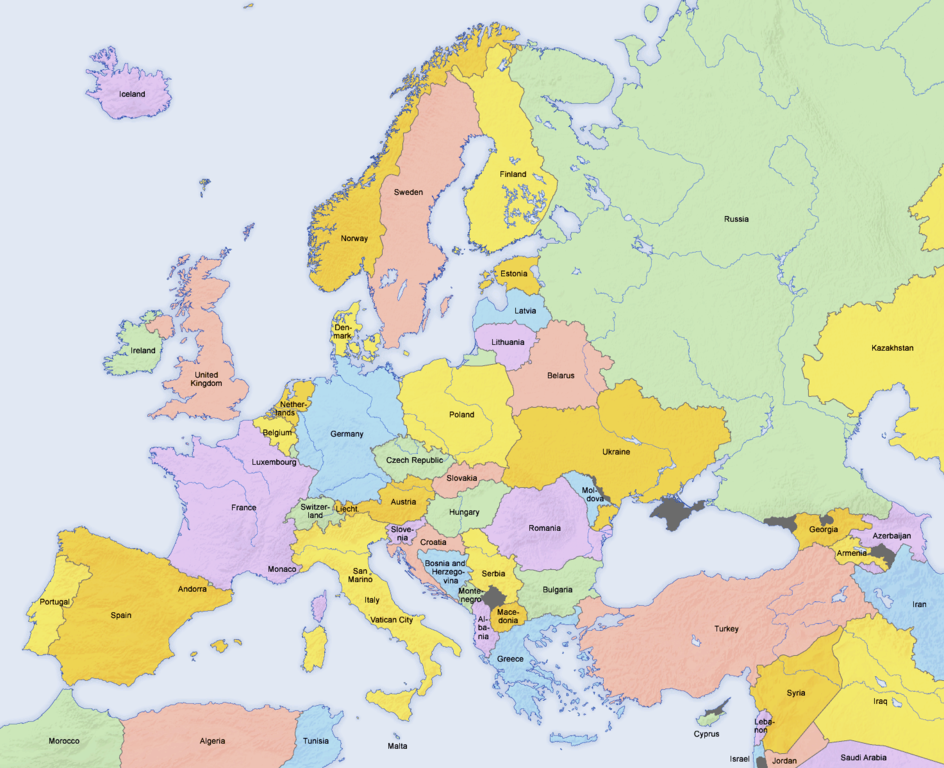
English: Map of countries in Europe and the surrounding region |
||||||||||
| ရက်စွဲ | 02.04.2006 | ||||||||||
| ရင်းမြစ် | Derivative work of Europe countries map en.png by San Jose, based on the Generic Mapping Tools and ETOPO2 | ||||||||||
| စာရေးသူ | San Jose (map), Hayden120 (retouch) | ||||||||||
| ခွင့်ပြုချက် (ဤဖိုင်ကို ပြန်လည်အသုံးပြုခြင်း) |
|
||||||||||
| အခြား ဗားရှင်းများ |
Derivative works of this file: Kinks International Tour 1969.jpg
[]
|


| This is a retouched picture, which means that it has been digitally altered from its original version. Modifications: Saturation, brightness, contrast. The original can be viewed here: Europe countries map en.png:
|
See also
_en.png)
.png)
.jpg)
ဖိုင်မှတ်တမ်း
ဖိုင်ကို ယင်းနေ့စွဲ အတိုင်း မြင်နိုင်ရန် နေ့စွဲ/အချိန် တစ်ခုခုပေါ်တွင် ကလစ်နှိပ်ပါ။
| နေ့စွဲ/အချိန် | နမူနာပုံငယ် | မှတ်တမ်း ဒိုင်မန်းရှင်းများ | အသုံးပြုသူ | မှတ်ချက် | |
|---|---|---|---|---|---|
| ကာလပေါ် | ၀၈:၂၄၊ ၇ အောက်တိုဘာ ၂၀၂၀ | | ၁၄၇၃ × ၁၁၉၈ (၁.၁၆ MB) | Wiz9999 | Corrected artefacts around polish border that had been introduced earlier. |
| ၁၈:၄၀၊ ၂၃ ဖေဖော်ဝါရီ ၂၀၁၈ |  | ၁၄၇၃ × ၁၁၉၈ (၁.၁၅ MB) | Wiz9999 | Fixed the colouration artifacts around Crimea, and added the remaining disputed territory around Eastern Europe. See EN:List of states with limited recognition and EN:List of sovereign states and dependent territories in Europe | |
| ၂၂:၃၃၊ ၁၆ ဖေဖော်ဝါရီ ၂၀၁၇ |  | ၁၄၇၃ × ၁၁၉၈ (၆၂၀ KB) | Fixingup | Revert. User warned. | |
| ၂၀:၅၂၊ ၁၆ ဖေဖော်ဝါရီ ၂၀၁၇ |  | ၁၄၇၃ × ၁၁၉၈ (၄၅၆ KB) | Satt 2 | ||
| ၀၅:၃၆၊ ၁၆ ဖေဖော်ဝါရီ ၂၀၁၇ |  | ၁၄၇၃ × ၁၁၉၈ (၆၂၀ KB) | Fixingup | There's already a map like this that has Crimea shown as Ukraine. This one shows it disputed. | |
| ၁၉:၃၁၊ ၁၅ ဖေဖော်ဝါရီ ၂၀၁၇ |  | ၁၄၇၃ × ၁၁၉၈ (၄၅၆ KB) | Satt 2 | ||
| ၂၃:၀၈၊ ၂၃ အောက်တိုဘာ ၂၀၁၄ |  | ၁၄၇၃ × ၁၁၉၈ (၆၂၀ KB) | Bobby Martnen | The status of the Crimea is disputed - so I changed it to gray to reflect that. | |
| ၂၂:၀၂၊ ၅ မေ ၂၀၁၄ |  | ၁၄၇၃ × ၁၁၉၈ (၄၅၆ KB) | Anastan | original image. Create new one for your "reality", not under this name | |
| ၁၆:၂၅၊ ၅ မေ ၂၀၁၄ |  | ၁၄၇၃ × ၁၁၉၈ (၁.၂၄ MB) | Denniss | Reverted to version as of 21:24, 15 January 2014 | |
| ၁၁:၀၁၊ ၅ မေ ၂၀၁၄ |  | ၁၄၇၃ × ၁၁၉၈ (၄၅၆ KB) | Tresnjevo | Previous version was neutral. |
ဖိုင်သုံးစွဲမှု
အောက်ပါ စာမျက်နှာ သည် ဤဖိုင်ကို အသုံးပြုထားသည်:
ဂလိုဘယ် ဖိုင်သုံးစွဲမှု
အောက်ပါ အခြားဝီကီများတွင် ဤဖိုင်ကို အသုံးပြုထားသည်-
- ar.wikipedia.org တွင် အသုံးပြုမှု
- ba.wikipedia.org တွင် အသုံးပြုမှု
- bh.wikipedia.org တွင် အသုံးပြုမှု
- bn.wikipedia.org တွင် အသုံးပြုမှု
- ca.wikipedia.org တွင် အသုံးပြုမှု
- de.wikipedia.org တွင် အသုံးပြုမှု
- en.wikipedia.org တွင် အသုံးပြုမှု
- en.wikibooks.org တွင် အသုံးပြုမှု
- fi.wikibooks.org တွင် အသုံးပြုမှု
- ga.wikipedia.org တွင် အသုံးပြုမှု
- gl.wikipedia.org တွင် အသုံးပြုမှု
- hy.wikipedia.org တွင် အသုံးပြုမှု
- incubator.wikimedia.org တွင် အသုံးပြုမှု
- ja.wikipedia.org တွင် အသုံးပြုမှု
- ka.wikipedia.org တွင် အသုံးပြုမှု
- ko.wikipedia.org တွင် အသုံးပြုမှု
- mn.wikipedia.org တွင် အသုံးပြုမှု
- myv.wikipedia.org တွင် အသုံးပြုမှု
- pa.wikipedia.org တွင် အသုံးပြုမှု
- pt.wikipedia.org တွင် အသုံးပြုမှု
- Categoria:Países da Europa
- Categoria:Rios da Europa
- Categoria:Montanhas da Europa
- Categoria:Penínsulas da Europa
- Categoria:Baías e golfos da Europa
- Categoria:Subdivisões de países da Europa
- Categoria:Estreitos da Europa
- Categoria:Vulcões da Europa
- Categoria:Museus da Europa
- Categoria:Pontes da Europa
- Categoria:Cidades da Europa
- Categoria:Reservas da biosfera da Europa
- Categoria:Parques nacionais da Europa
- Predefinição:CatpaísesEuropa
- Categoria:História da Europa por país
- scn.wikipedia.org တွင် အသုံးပြုမှု
- simple.wikipedia.org တွင် အသုံးပြုမှု
- sr.wikipedia.org တွင် အသုံးပြုမှု
- te.wikipedia.org တွင် အသုံးပြုမှု
ဤဖိုင်ကို အခြားနေရာများတွင် အသုံးပြုထားမှုများအား ကြည့်ရှုရန်။