
ဖိုင်:Europe-Isle of Man.svg

Size of this PNG preview of this SVG file: ၇၁၃ × ၆၀၀ ပစ်ဇယ်. အခြား ပုံရိပ်ပြတ်သားမှု: ၂၈၅ × ၂၄၀ ပစ်ဇယ် | ၅၇၁ × ၄၈၀ ပစ်ဇယ် | ၉၁၃ × ၇၆၈ ပစ်ဇယ် | ၁၂၁၈ × ၁၀၂၄ ပစ်ဇယ် | ၂၄၃၅ × ၂၀၄၈ ပစ်ဇယ် | ၂၀၄၅ × ၁၇၂၀ ပစ်ဇယ်။
မူရင်းဖိုင် (SVG ဖိုင်, ၂၀၄၅ × ၁၇၂၀ pixels ကို အကြံပြုသည်, ဖိုင်အရွယ်အစား - ၂.၂၄ MB)
| ဤဖိုင်သည် Wikimedia Commons မှဖြစ်ပြီး အခြားပရောဂျက်များတွင် သုံးကောင်းသုံးလိမ့်မည်။ ယင်း၏ ဖိုင်အကြောင်းစာမျက်နှာ တွင် ဖော်ပြထားချက်ကို အောက်တွင် ပြထားသည်။ Commons သည် မူပိုင်ခွင့်လွတ်လပ်သော မီဒီယာဖိုင်များ သိုလှောင်ထားရာ နေရာ ဖြစ်သည်။ သင်လည်း ပါဝင်ကူညီနိုင်ပါသည်။ |
အကျဉ်းချုပ်
| ဖော်ပြချက် |
English:
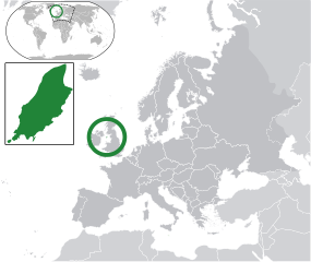
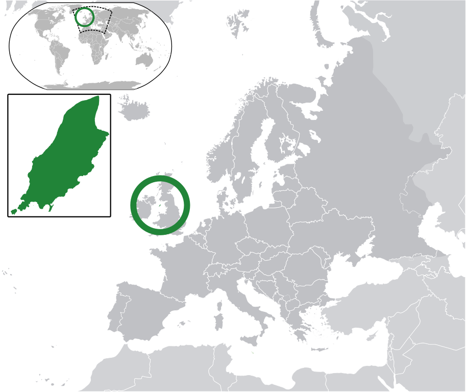
Map in English of the Isle of Man, with bounds of sheadings, towns, villages, districts and parishes. (Green) Isle of Man.
(Gray) Europe.
(Light-gray) The surrounding region.
The Full Map of the Isle of Man |
||
| ရက်စွဲ | |||
| ရင်းမြစ် | Own work based on: IsleOfMan SheadingsAndParishes-en.svg | ||
| စာရေးသူ | Chipmunkdavis | ||
| ခွင့်ပြုချက် (ဤဖိုင်ကို ပြန်လည်အသုံးပြုခြင်း) |
ဤဖိုင်ကို Creative Commons Attribution-Share Alike 3.0 Unported လိုင်စင်ဖြင့် သတ်မှတ်ထားသည်။
|
||
| SVG genesis |
|
မူရင်းတင်ထားသောမှတ်တမ်း
This image is a derivative work of the following images:
- licensed with Cc-by-sa-3.0
- 2011-02-21T07:49:57Z Chipmunkdavis 2045x1720 (2394864 Bytes)
- IsleOfMan SheadingsAndParishes-en.svg licensed with Cc-by-sa-3.0,2.5,2.0,1.0, GFDL
- 2008-01-17T12:48:28Z Sémhur 1200x1100 (227618 Bytes) Update
- 2007-05-29T20:36:04Z Sémhur 0x0 (364350 Bytes) {{Information |Description=Map in English of the [[:en:Isle of Man|Isle of Man]], with bounds of sheadings, towns, villages, districts and parishes. |Source=Own work. Based on maps [[:Image:Isle of Man map-fr.svg]], [[:Image:
Uploaded with derivativeFX
ဖိုင်မှတ်တမ်း
ဖိုင်ကို ယင်းနေ့စွဲ အတိုင်း မြင်နိုင်ရန် နေ့စွဲ/အချိန် တစ်ခုခုပေါ်တွင် ကလစ်နှိပ်ပါ။
| နေ့စွဲ/အချိန် | နမူနာပုံငယ် | မှတ်တမ်း ဒိုင်မန်းရှင်းများ | အသုံးပြုသူ | မှတ်ချက် | |
|---|---|---|---|---|---|
| ကာလပေါ် | ၀၆:၁၀၊ ၂ မတ် ၂၀၁၁ | | ၂၀၄၅ × ၁၇၂၀ (၂.၂၄ MB) | Chipmunkdavis | Redid inset |
| ၀၆:၀၃၊ ၂ မတ် ၂၀၁၁ |  | ၂၀၄၅ × ၁၇၂၀ (၂.၂၂ MB) | Chipmunkdavis | Without inset | |
| ၀၆:၀၁၊ ၂ မတ် ၂၀၁၁ |  | ၂၀၄၅ × ၁၇၂၀ (၂.၂၂ MB) | Chipmunkdavis | One more try | |
| ၀၉:၀၃၊ ၂၁ ဖေဖော်ဝါရီ ၂၀၁၁ |  | ၂၀၄၅ × ၁၇၂၀ (၂.၂၂ MB) | Chipmunkdavis | Grouped inset | |
| ၀၉:၀၀၊ ၂၁ ဖေဖော်ဝါရီ ၂၀၁၁ |  | ၂၀၄၅ × ၁၇၂၀ (၂.၂၂ MB) | Chipmunkdavis | File not appearing properly, reuploading | |
| ၀၈:၀၆၊ ၂၁ ဖေဖော်ဝါရီ ၂၀၁၁ |  | ၂၀၄၅ × ၁၇၂၀ (၂.၂၂ MB) | Chipmunkdavis | {{Information |Description={{en|1={{Europe-SVG-en|Northern Cyprus}}}} {{en|1=The Full Map of Jersey}} Map in english of the Isle of Man, with bounds of sheadings, towns, villages, districts and parishes. |Source=*[[:File:Europe-Jersey. |
ဖိုင်သုံးစွဲမှု
အောက်ပါ စာမျက်နှာ သည် ဤဖိုင်ကို အသုံးပြုထားသည်:
ဂလိုဘယ် ဖိုင်သုံးစွဲမှု
အောက်ပါ အခြားဝီကီများတွင် ဤဖိုင်ကို အသုံးပြုထားသည်-
- ace.wikipedia.org တွင် အသုံးပြုမှု
- an.wikipedia.org တွင် အသုံးပြုမှု
- ar.wikipedia.org တွင် အသုံးပြုမှု
- arz.wikipedia.org တွင် အသုံးပြုမှု
- ast.wikipedia.org တွင် အသုံးပြုမှု
- az.wikipedia.org တွင် အသုံးပြုမှု
- ba.wikipedia.org တွင် အသုံးပြုမှု
- bg.wikipedia.org တွင် အသုံးပြုမှု
- bh.wikipedia.org တွင် အသုံးပြုမှု
- bn.wikipedia.org တွင် အသုံးပြုမှု
- ca.wikipedia.org တွင် အသုံးပြုမှု
- cdo.wikipedia.org တွင် အသုံးပြုမှု
- cs.wikipedia.org တွင် အသုံးပြုမှု
- diq.wikipedia.org တွင် အသုံးပြုမှု
- en.wikipedia.org တွင် အသုံးပြုမှု
- eo.wikipedia.org တွင် အသုံးပြုမှု
- es.wikipedia.org တွင် အသုံးပြုမှု
- ext.wikipedia.org တွင် အသုံးပြုမှု
- fi.wiktionary.org တွင် အသုံးပြုမှု
- fr.wikipedia.org တွင် အသုံးပြုမှု
- ga.wikipedia.org တွင် အသုံးပြုမှု
- gl.wikipedia.org တွင် အသုံးပြုမှု
- hak.wikipedia.org တွင် အသုံးပြုမှု
- ha.wikipedia.org တွင် အသုံးပြုမှု
- he.wikipedia.org တွင် အသုံးပြုမှု
- ia.wikipedia.org တွင် အသုံးပြုမှု
- incubator.wikimedia.org တွင် အသုံးပြုမှု
- it.wikipedia.org တွင် အသုံးပြုမှု
- ja.wikipedia.org တွင် အသုံးပြုမှု
- kab.wikipedia.org တွင် အသုံးပြုမှု
- kk.wikipedia.org တွင် အသုံးပြုမှု
- km.wikipedia.org တွင် အသုံးပြုမှု
- la.wikipedia.org တွင် အသုံးပြုမှု
- lb.wikipedia.org တွင် အသုံးပြုမှု
- lij.wikipedia.org တွင် အသုံးပြုမှု
- mk.wikipedia.org တွင် အသုံးပြုမှု
- nds.wikipedia.org တွင် အသုံးပြုမှု
ဤဖိုင်ကို အခြားနေရာများတွင် အသုံးပြုထားမှုများအား ကြည့်ရှုရန်။