
ဖိုင်:Départements et régions de France.svg

Size of this PNG preview of this SVG file: ၅၈၈ × ၅၅၀ ပစ်ဇယ်. အခြား ပုံရိပ်ပြတ်သားမှု: ၂၅၇ × ၂၄၀ ပစ်ဇယ် | ၅၁၃ × ၄၈၀ ပစ်ဇယ် | ၈၂၁ × ၇၆၈ ပစ်ဇယ် | ၁၀၉၅ × ၁၀၂၄ ပစ်ဇယ် | ၂၁၉၀ × ၂၀၄၈ ပစ်ဇယ်။
မူရင်းဖိုင် (SVG ဖိုင်, ၅၈၈ × ၅၅၀ pixels ကို အကြံပြုသည်, ဖိုင်အရွယ်အစား - ၃၆၂ KB)
| ဤဖိုင်သည် Wikimedia Commons မှဖြစ်ပြီး အခြားပရောဂျက်များတွင် သုံးကောင်းသုံးလိမ့်မည်။ ယင်း၏ ဖိုင်အကြောင်းစာမျက်နှာ တွင် ဖော်ပြထားချက်ကို အောက်တွင် ပြထားသည်။ Commons သည် မူပိုင်ခွင့်လွတ်လပ်သော မီဒီယာဖိုင်များ သိုလှောင်ထားရာ နေရာ ဖြစ်သည်။ သင်လည်း ပါဝင်ကူညီနိုင်ပါသည်။ |
အကျဉ်းချုပ်
| ဖော်ပြချက် |
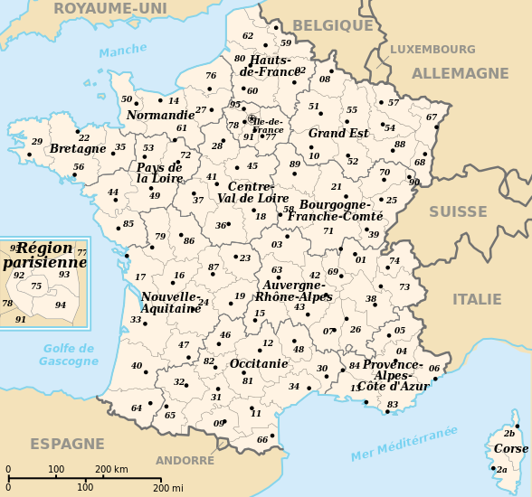
 English: Departements and region of France. French geographics objects use ISO 3166-2:FR for ids.
Español: Mapa de los departamentos franceses.
Français : Départements et régions de France avec leurs préfectures. Les objects géographiques français utilisent les identifiants provenant de ISO 3166-2:FR |
||
| ရက်စွဲ | |||
| ရင်းမြစ် | ကိုယ်ပိုင်ဖန်တီးမှု | ||
| စာရေးသူ | bayo | ||
| ခွင့်ပြုချက် (ဤဖိုင်ကို ပြန်လည်အသုံးပြုခြင်း) |
|
||
| အခြား ဗားရှင်းများ |
[]
|
![(français) Départements (numérotés) et régions de France avant 01/01/2016 (nommées, non colorisés) [source of all the following derivatives]](http://commons.wikimedia.org/wiki/File:D%C3%A9partements_et_r%C3%A9gions_de_France.svg)


![(français) Départements (numérotés) et régions de France avant 01/01/2016 (non nommées, non colorisées) [rendu amélioré] (version utilisée pour rendre la carte clicable par département)](http://commons.wikimedia.org/wiki/File:D%C3%A9partements_et_r%C3%A9gions_de_France_-_Noname-2016.svg)


![(français) Départements (numérotés) et régions de France avant 01/01/2016 (nommées et colorisées) [regions named/colored]](http://commons.wikimedia.org/wiki/File:D%C3%A9partements%2Br%C3%A9gions_(France).svg)
![(français) Départements (numérotés) et régions de France avant 01/01/2016 (nommées et colorisées) [15% magnified, rapid JPEG format 5x faster]](http://commons.wikimedia.org/wiki/File:France_departements_regions_narrow.jpg)
![(français) Départements de France (numérotés, non colorisés)[numeric labels, uncolorized]](http://commons.wikimedia.org/wiki/File:D%C3%A9partements_de_France.svg)


![(multilingue) Départements de France (sans aucun libellé) [No labels]](http://commons.wikimedia.org/wiki/File:D%C3%A9partements_et_r%C3%A9gions_de_France_vide.svg)
ဖိုင်မှတ်တမ်း
ဖိုင်ကို ယင်းနေ့စွဲ အတိုင်း မြင်နိုင်ရန် နေ့စွဲ/အချိန် တစ်ခုခုပေါ်တွင် ကလစ်နှိပ်ပါ။
| နေ့စွဲ/အချိန် | နမူနာပုံငယ် | မှတ်တမ်း ဒိုင်မန်းရှင်းများ | အသုံးပြုသူ | မှတ်ချက် | |
|---|---|---|---|---|---|
| ကာလပေါ် | ၁၁:၅၀၊ ၂၆ ဧပြီ ၂၀၂၄ | | ၅၈၈ × ၅၅၀ (၃၆၂ KB) | Jack ma | - correction of region limits (closing of Grand Est and Nouvelle-Aquitaine) |
| ၀၉:၀၂၊ ၁၂ ဧပြီ ၂၀၂၄ |  | ၅၈၈ × ၅၅၀ (၄၃၈ KB) | Jack ma | Updated French administrative regions of 2016 | |
| ၁၆:၁၈၊ ၂၂ ဇူလိုင် ၂၀၁၄ |  | ၅၈၈ × ၅၅၀ (၄၆၆ KB) | Seudo | Fixed orthograph mistake ("région parisenne") and added hyphens in Pays-de-la-Loire | |
| ၀၂:၅၅၊ ၁၆ မေ ၂၀၀၉ |  | ၅၈၈ × ၅၅၀ (၄၆၆ KB) | Archimatth | Une seule préfecture varoise | |
| ၀၇:၂၆၊ ၂၀ ဇွန် ၂၀၀၈ |  | ၅၈၈ × ၅၅၀ (၄၆၇ KB) | Bayo | patch region/departement id with ISO 3166-2:FR | |
| ၀၉:၀၂၊ ၁၇ ဇွန် ၂၀၀၈ |  | ၅၈၈ × ၅၅၀ (၄၇၄ KB) | Bayo | {{Information |Description= |Source= |Date= |Author= |Permission= |other_versions= }} | |
| ၁၆:၅၆၊ ၁၀ မေ ၂၀၀၈ |  | ၅၈၈ × ၅၅၀ (၄၅၉ KB) | Bayo | region name bigger, patch typo of some names | |
| ၂၀:၃၄၊ ၂၂ မေ ၂၀၀၆ |  | ၅၈၈ × ၅၅၀ (၄၅၉ KB) | Bayo | patch : typo | |
| ၁၅:၁၁၊ ၁၇ ဧပြီ ၂၀၀၆ |  | ၅၈၈ × ၅၅၀ (၄၅၉ KB) | Bayo | ajout de l'échelle | |
| ၁၄:၄၅၊ ၁၇ ဧပြီ ၂၀၀၆ |  | ၅၈၈ × ၅၅၀ (၄၅၅ KB) | Bayo | *'''description''' : Départements et régions et de France avec leurs préfectures. *'''auteur''' : bayo Category:Maps of departements of France Category:Maps of régions of France == Licensing == {{PD-self}} |
ဖိုင်သုံးစွဲမှု
ဤဖိုင်ကို အသုံးပြုထားသော စာမျက်နှာများမရှိပါ။
ဂလိုဘယ် ဖိုင်သုံးစွဲမှု
အောက်ပါ အခြားဝီကီများတွင် ဤဖိုင်ကို အသုံးပြုထားသည်-
- af.wikipedia.org တွင် အသုံးပြုမှု
- ceb.wikipedia.org တွင် အသုံးပြုမှု
- da.wikipedia.org တွင် အသုံးပြုမှု
- es.wikipedia.org တွင် အသုံးပြုမှု
- eu.wikipedia.org တွင် အသုံးပြုမှု
- fi.wikipedia.org တွင် အသုံးပြုမှု
- fr.wikipedia.org တွင် အသုံးပြုမှု
- Aménagement du territoire en France
- Discussion modèle:Fragéoloc
- Wikipédia:Atelier graphique/Images à améliorer/Archives/Novembre 2006
- Wikipédia:Atelier graphique/Images à améliorer/Archives/Mai 2007
- Discussion utilisateur:Mirondia
- Utilisateur:Wikisoft*/Tests cartes
- Discussion utilisateur:Sting/Archive 08
- Patrimoine juif d'Alsace
- Patrimoine juif de Lorraine
- Patrimoine juif du Sud-Est de la France et de la principauté de Monaco
- Patrimoine juif d'Île-de-France
- Patrimoine juif du Sud-Ouest de la France
- Patrimoine juif des régions du centre, partie ouest
- Patrimoine juif du Nord et de l'Est de la France (sauf Alsace et Lorraine)
- Patrimoine protestant de Lorraine
- ia.wikipedia.org တွင် အသုံးပြုမှု
- la.wikipedia.org တွင် အသုံးပြုမှု
- lt.wikipedia.org တွင် အသုံးပြုမှု
- oc.wikipedia.org တွင် အသုံးပြုမှု
- pt.wikipedia.org တွင် အသုံးပြုမှု
- qu.wikipedia.org တွင် အသုံးပြုမှု
- se.wikipedia.org တွင် အသုံးပြုမှု
- vi.wikipedia.org တွင် အသုံးပြုမှု