ဖိုင်:Chad relief location map.jpg
အခြားဘာသာစကားများဖြင့် စာမျက်နှာအကြောင်းအရာများကို ပံ့ပိုးမထားပါ။
This is a file from the Wikimedia Commons
ဝီကီပီးဒီးယား မှ

မူရင်းဖိုင်(၈၉၉ × ၁၃၄၉ pixels, ဖိုင်အရွယ်အစား - ၁၉၇ KB, MIME အမျိုးအစား image/jpeg)

အကျဉ်းချုပ်

Camera location၁၅° ၂၇′ ၀၀″ N, ၁၈° ၄၃′ ၃၀″ E Kartographer map based on OpenStreetMap.View this and other nearby images on: OpenStreetMapinfo


ဖော်ပြချက်
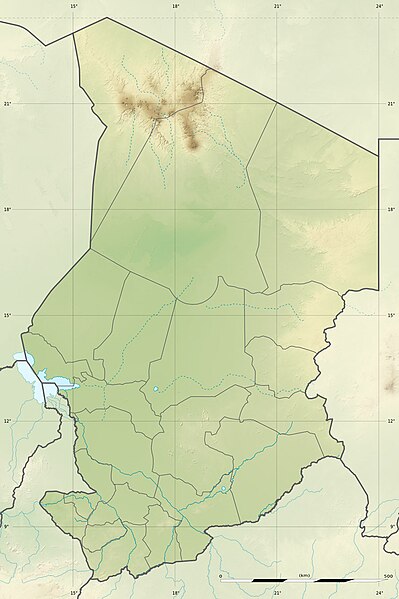
English: Blank physical map of Chad as since the 2008-02 reform of the Regions, for geo-location purposes.
Français : Carte physique vierge du Tchad telle que depuis la réforme des Régions de février 2008, destinée à la géolocalisation.

Scale: 1:5,600,000 (precision: 1,400 m)
Equirectangular projection, WGS84 datum

  • Central meridian: 018° 43' 30" E
  • Standard parallel: 15° 27' N

Geographic limits of the map:

  • Top: 23° 57' N
  • Bottom: 06° 57' N
  • Left: 012° 51' E
  • Right: 024° 36' E
ရက်စွဲ 2009-11, updated 2011-07
ရင်းမြစ်

ကိုယ်ပိုင်ဖန်တီးမှု

  • Sources of data:
    • SRTM30 Plus;
    • NGDC World Data Bank II (public domain);
    • NGDC GSHHS (public domain);
    • Map Library (public domain);
    • Regions boundaries corrected using the March 2009 UN's map.
စာရေးသူ Eric Gaba (Sting - fr:Sting)
ခွင့်ပြုချက်
(ဤဖိုင်ကို ပြန်လည်အသုံးပြုခြင်း)
Attribution and Share-Alike required
အခြား ဗားရှင်းများ

လိုင်စင်သတ်မှတ်ခြင်း

ကျွန်ုပ်၊ ဤလုပ်ဆောင်ချက်၏ မူပိုင်ခွင့်ပိုင်ရှင်အနေဖြင့် ဤနေရာမှ အောက်ပါလိုင်စင်များအောက်တွင် ထုတ်လွှင့်ပါသည်:
w:my:Creative Commons
မှတ်ယူနိုင်ခြင်း ထပ်တူမျှဝေ
ဤဖိုင်ကို Creative Commons Attribution-Share Alike 3.0 Unported လိုင်စင်ဖြင့် သတ်မှတ်ထားသည်။
သင်သည် လွတ်လပ်စွာ:
  • မျှဝေရန် – ဖန်တီးမှုကို ကူးယူရန်၊ ဖြန့်ဖြူးရန်နှင့် ထုတ်လွှင့်ရန်
  • ပြန်ရောနှောရန် – ဖန်တီးမှုကို ပြင်ဆင်ညှိနှိုင်းရန်
အောက်ပါ အခြေအနေများတွင်:
  • မှတ်ယူနိုင်ခြင်း – ပြောင်းလဲမှုများ ပြုလုပ်ခဲ့ပါက ဖန်တီးသူ သို့မဟုတ် လိုင်စင်ရှိသူမှ သတ်မှတ်သော အမျိုးအစားကို လိုက်နာရမည် (ဆိုလိုသည်မှာ သင့်အား သို့မဟုတ် သင့်ဖန်တီးမှုတွင် အသုံးပြုခြင်းအား ထောက်ခံချက်ပေးသည်ဟု မဆိုလိုပါ)။
  • ထပ်တူမျှဝေ – ဤဖန်တီးမှုအား ပြင်ဆင်ခြင်း၊ ပြောင်းလဲခြင်း သို့မဟုတ် ထပ်ဆင့် ဖန်တီးခြင်း ပြုလုပ်ပါက ရရှိလာသော ဖန်တီးမှုကို ဤဖန်တီးမှုနှင့် သို့မဟုတ် ဆင်တူသော လိုင်စင်ဖြင့်သာ ဖြန့်ချိသင့်သည်။
GNU head ဤစာတမ်းကို GNU Free Documentation License, ဗားရှင်း ၁.၂ သို့မဟုတ် Free Software Foundation မှ ဖြန့်ချီထားသော မည်သည့်ယခင်ဗားရှင်းတစ်ခုခုအောက်တွင် Invariant Sections, Front-Cover Texts နှင့် Back-Cover Texts များမပါဝင်ဘဲ ကူးယူခြင်း၊ ဖြန့်ချီခြင်း နှင့်/သို့မဟုတ် ပြင်ဆင်ပြောင်းလဲနိုင်ရန် ခွင့်ပြုသည်။ လိုင်စင်မူပွားကို GNU Free Documentation License ခေါင်းစဉ်အောက်တွင် ထည့်သွင်းထားသည်။
သင်အလိုရှိရာ လိုင်စင်ကို ရွေးချယ်နိုင်ပါသည်။

ပုံစာများ

ဤဖိုင်၏ဆိုလိုရင်းကို စာတစ်ကြောင်းရှင်းလင်းချက်ဖြင့် ထည့်သွင်းရန်

Items portrayed in this file

depicts အင်္ဂလိပ်

some value

object has role အင်္ဂလိပ်: photographer အင်္ဂလိပ်
author name string အင်္ဂလိပ်: Sting
Wikimedia username အင်္ဂလိပ်: Sting

coordinates of the point of view အင်္ဂလိပ်

15°27'0.000"N, 18°43'30.000"E

MIME type အင်္ဂလိပ်

image/jpeg

checksum အင်္ဂလိပ်

1bda2852a7bd5d18be96746683cd0d5ef1fe14f3

determination method အင်္ဂလိပ်: SHA-1 အင်္ဂလိပ်

data size အင်္ဂလိပ်

၂၀၁၃၇၃ ဘိုက်

height အင်္ဂလိပ်

၁၃၄၉ pixel

width အင်္ဂလိပ်

၈၉၉ pixel

ဖိုင်မှတ်တမ်း

ဖိုင်ကို ယင်းနေ့စွဲ အတိုင်း မြင်နိုင်ရန် နေ့စွဲ/အချိန် တစ်ခုခုပေါ်တွင် ကလစ်နှိပ်ပါ။

နေ့စွဲ/အချိန်နမူနာပုံငယ်မှတ်တမ်း ဒိုင်မန်းရှင်းများအသုံးပြုသူမှတ်ချက်
ကာလပေါ် ၂၂:၂၁၊ ၁၄ ဇူလိုင် ၂၀၁၁ ၂၂:၂၁၊ ၁၄ ဇူလိုင် ၂၀၁၁ ရက်က မူအတွက် နမူနာပုံငယ်၈၉၉ × ၁၃၄၉ (၁၉၇ KB)StingSudan/South Sudan 2011-07 border update
၁၃:၂၀၊ ၁၉ ဇူလိုင် ၂၀၁၀ ၁၃:၂၀၊ ၁၉ ဇူလိုင် ၂၀၁၀ ရက်က မူအတွက် နမူနာပုံငယ်၈၉၉ × ၁၃၄၉ (၂၄၁ KB)StingColor profile
၂၃:၂၆၊ ၂၃ နိုဝင်ဘာ ၂၀၀၉ ၂၃:၂၆၊ ၂၃ နိုဝင်ဘာ ၂၀၀၉ ရက်က မူအတွက် နမူနာပုံငယ်၈၉၉ × ၁၃၄၉ (၂၄၂ KB)Sting== {{int:filedesc}} == {{Location|15|27|00|N|18|43|30|E|scale:7000000}} <br/> {{Information |Description={{en|Blank physical map of Chad as after the 2008-02 reform of the Regions, for geo-location purposes.}} {{fr|Carte physique vierge du [[

အောက်ပါ 6 စာမျက်နှာများ သည် ဤဖိုင်ကို အသုံးပြုထားသည်:

ဂလိုဘယ် ဖိုင်သုံးစွဲမှု

အောက်ပါ အခြားဝီကီများတွင် ဤဖိုင်ကို အသုံးပြုထားသည်-

ဤဖိုင်ကို အခြားနေရာများတွင် အသုံးပြုထားမှုများအား ကြည့်ရှုရန်။

မီတာဒေတာ