
ဖိုင်:Buyids 970.png

ဤနမူနာ၏ အရွယ်အစား - ၈၀၀ × ၅၀၉ ပစ်ဇယ်။ အခြား ပုံရိပ်ပြတ်သားမှု: ၃၂၀ × ၂၀၄ ပစ်ဇယ် | ၆၄၀ × ၄၀၇ ပစ်ဇယ် | ၁၀၂၄ × ၆၅၂ ပစ်ဇယ် | ၁၃၂၁ × ၈၄၁ ပစ်ဇယ်။
မူရင်းဖိုင် (၁၃၂၁ × ၈၄၁ pixels, ဖိုင်အရွယ်အစား - ၁.၀၁ MB, MIME အမျိုးအစား image/png)
| ဤဖိုင်သည် Wikimedia Commons မှဖြစ်ပြီး အခြားပရောဂျက်များတွင် သုံးကောင်းသုံးလိမ့်မည်။ ယင်း၏ ဖိုင်အကြောင်းစာမျက်နှာ တွင် ဖော်ပြထားချက်ကို အောက်တွင် ပြထားသည်။ Commons သည် မူပိုင်ခွင့်လွတ်လပ်သော မီဒီယာဖိုင်များ သိုလှောင်ထားရာ နေရာ ဖြစ်သည်။ သင်လည်း ပါဝင်ကူညီနိုင်ပါသည်။ |
အကျဉ်းချုပ်
| ဖော်ပြချက် |
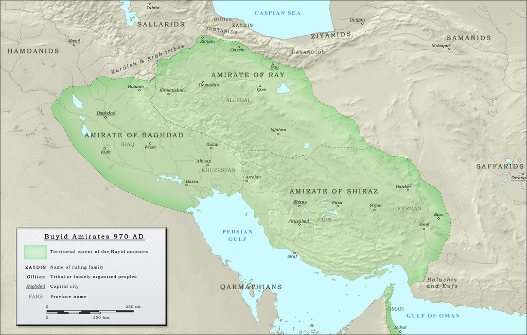
English: Map of the three emirates under control of the Buyid dynasty ca. 970 CE |
| ရက်စွဲ | |
| ရင်းမြစ် |
(Original text : Own work. Data sources :
|
| စာရေးသူ | ro4444 |
| ခွင့်ပြုချက် (ဤဖိုင်ကို ပြန်လည်အသုံးပြုခြင်း) |
. Original uploader was Ro4444 at en.wikipedia CC-BY-SA-3.0; Released under the GNU Free Documentation License; Released into the public domain (by the author). |
| အခြား ဗားရှင်းများ | العربيَّة |
လိုင်စင်သတ်မှတ်ခြင်း
| This work has been released into the public domain by its author, Ro4444 at အင်္ဂလိပ် ဝီကီပီးဒီးယား. This applies worldwide. In some countries this may not be legally possible; if so: Ro4444 grants anyone the right to use this work for any purpose, without any conditions, unless such conditions are required by law. |
Ro4444 at အင်္ဂလိပ် ဝီကီပီးဒီးယား၊ ဤလုပ်ဆောင်ချက်၏ မူပိုင်ခွင့်ပိုင်ရှင်အနေဖြင့် ဤနေရာမှ အောက်ပါလိုင်စင်များအောက်တွင် ထုတ်လွှင့်ပါသည်:
ဤဖိုင်ကို Creative Commons Attribution-Share Alike 3.0 Unported လိုင်စင်ဖြင့် သတ်မှတ်ထားသည်။
မှတ်ယူနိုင်ခြင်း: Ro4444 at အင်္ဂလိပ် ဝီကီပီးဒီးယား
- သင်သည် လွတ်လပ်စွာ:
- မျှဝေရန် – ဖန်တီးမှုကို ကူးယူရန်၊ ဖြန့်ဖြူးရန်နှင့် ထုတ်လွှင့်ရန်
- ပြန်ရောနှောရန် – ဖန်တီးမှုကို ပြင်ဆင်ညှိနှိုင်းရန်
- အောက်ပါ အခြေအနေများတွင်:
- မှတ်ယူနိုင်ခြင်း – ပြောင်းလဲမှုများ ပြုလုပ်ခဲ့ပါက ဖန်တီးသူ သို့မဟုတ် လိုင်စင်ရှိသူမှ သတ်မှတ်သော အမျိုးအစားကို လိုက်နာရမည် (ဆိုလိုသည်မှာ သင့်အား သို့မဟုတ် သင့်ဖန်တီးမှုတွင် အသုံးပြုခြင်းအား ထောက်ခံချက်ပေးသည်ဟု မဆိုလိုပါ)။
- ထပ်တူမျှဝေ – ဤဖန်တီးမှုအား ပြင်ဆင်ခြင်း၊ ပြောင်းလဲခြင်း သို့မဟုတ် ထပ်ဆင့် ဖန်တီးခြင်း ပြုလုပ်ပါက ရရှိလာသော ဖန်တီးမှုကို ဤဖန်တီးမှုနှင့် သို့မဟုတ် ဆင်တူသော လိုင်စင်ဖြင့်သာ ဖြန့်ချိသင့်သည်။

|
ဤစာတမ်းကို GNU Free Documentation License, ဗားရှင်း ၁.၂ သို့မဟုတ် Free Software Foundation မှ ဖြန့်ချီထားသော မည်သည့်ယခင်ဗားရှင်းတစ်ခုခုအောက်တွင် Invariant Sections, Front-Cover Texts နှင့် Back-Cover Texts များမပါဝင်ဘဲ ကူးယူခြင်း၊ ဖြန့်ချီခြင်း နှင့်/သို့မဟုတ် ပြင်ဆင်ပြောင်းလဲနိုင်ရန် ခွင့်ပြုသည်။ လိုင်စင်မူပွားကို GNU Free Documentation License ခေါင်းစဉ်အောက်တွင် ထည့်သွင်းထားသည်။ |
သင်အလိုရှိရာ လိုင်စင်ကို ရွေးချယ်နိုင်ပါသည်။
မူရင်းတင်ထားသောမှတ်တမ်း
ဖော်ပြချက် မူရင်းစာမျက်နှာမှာ here ဖြစ်သည်။ အောက်ပါအသုံးပြုသူ အမည်များအားလုံးသည် en.wikipedia ကို ရည်ညွှန်းသည်။
- 2010-09-27 05:16 Ro4444 1321×841× (1059156 bytes) == Summary == == Description == {{Information |Description= {{en| Political map in English of the Buyids in 970 A.D.}} |Source=Own work. {{clr}} Data sources : * Background map : [[Topographic map#Global 1-kilometer map]] (SRTM3 v.2) (public domain){{clr}
ဖိုင်မှတ်တမ်း
ဖိုင်ကို ယင်းနေ့စွဲ အတိုင်း မြင်နိုင်ရန် နေ့စွဲ/အချိန် တစ်ခုခုပေါ်တွင် ကလစ်နှိပ်ပါ။
| နေ့စွဲ/အချိန် | နမူနာပုံငယ် | မှတ်တမ်း ဒိုင်မန်းရှင်းများ | အသုံးပြုသူ | မှတ်ချက် | |
|---|---|---|---|---|---|
| ကာလပေါ် | ၁၅:၂၄၊ ၂၅ ဇူလိုင် ၂၀၁၂ | | ၁၃၂၁ × ၈၄၁ (၁.၀၁ MB) | Cplakidas | {{Information |Description={{en|Map of the three emirates under control of the en:Buyid dynasty ca. 970 CE}} |Source=Transferred from [http://en.wikipedia.org en.wikipedia]<br/> (Original text : ''Own work. Data sources : * Background map : [[:en... |
ဖိုင်သုံးစွဲမှု
အောက်ပါ စာမျက်နှာ သည် ဤဖိုင်ကို အသုံးပြုထားသည်:
ဂလိုဘယ် ဖိုင်သုံးစွဲမှု
အောက်ပါ အခြားဝီကီများတွင် ဤဖိုင်ကို အသုံးပြုထားသည်-
- arz.wikipedia.org တွင် အသုံးပြုမှု
- ast.wikipedia.org တွင် အသုံးပြုမှု
- azb.wikipedia.org တွင် အသုံးပြုမှု
- az.wikipedia.org တွင် အသုံးပြုမှု
- ba.wikipedia.org တွင် အသုံးပြုမှု
- be.wikipedia.org တွင် အသုံးပြုမှု
- bg.wikipedia.org တွင် အသုံးပြုမှု
- bn.wikipedia.org တွင် အသုံးပြုမှု
- ckb.wikipedia.org တွင် အသုံးပြုမှု
- de.wikipedia.org တွင် အသုံးပြုမှု
- diq.wikipedia.org တွင် အသုံးပြုမှု
- el.wikipedia.org တွင် အသုံးပြုမှု
- en.wikipedia.org တွင် အသုံးပြုမှု
- Ilam province
- Buyid dynasty
- Al-Malik al-Rahim
- Abu Kalijar
- Jalal al-Dawla
- Musharrif al-Dawla
- Sultan al-Dawla
- Baha al-Dawla
- Sharaf al-Dawla
- Samsam al-Dawla
- Izz al-Dawla
- Mu'izz al-Dawla
- Qawam al-Dawla
- Taj al-Dawla
- Diya al-Dawla
- Sama' al-Dawla
- Shams al-Dawla
- Fakhr al-Dawla
- Rukn al-Dawla
- Imad al-Dawla
- Mu'ayyad al-Dawla
- Majd al-Dawla
- 'Adud al-Dawla
- Greater Iran
- History of Shia Islam
- Abu Mansur Fulad Sutun
- Template:Buyid dynasty
- Abu Sa'd Khusrau Shah
- Abu Ishaq Ibrahim (Buyid)
- User:Chickstarr404/Gather lists/4913 – Samarkland by Amin Maalouf
ဤဖိုင်ကို အခြားနေရာများတွင် အသုံးပြုထားမှုများအား ကြည့်ရှုရန်။