
ဖိုင်:Borneo Topography.png

ဤနမူနာ၏ အရွယ်အစား - ၅၆၇ × ၆၀၀ ပစ်ဇယ်။ အခြား ပုံရိပ်ပြတ်သားမှု: ၂၂၇ × ၂၄၀ ပစ်ဇယ် | ၄၅၄ × ၄၈၀ ပစ်ဇယ် | ၇၂၆ × ၇၆၈ ပစ်ဇယ် | ၉၆၈ × ၁၀၂၄ ပစ်ဇယ် | ၁၇၂၅ × ၁၈၂၄ ပစ်ဇယ်။
မူရင်းဖိုင် (၁၇၂၅ × ၁၈၂၄ pixels, ဖိုင်အရွယ်အစား - ၂.၅၂ MB, MIME အမျိုးအစား image/png)
| ဤဖိုင်သည် Wikimedia Commons မှဖြစ်ပြီး အခြားပရောဂျက်များတွင် သုံးကောင်းသုံးလိမ့်မည်။ ယင်း၏ ဖိုင်အကြောင်းစာမျက်နှာ တွင် ဖော်ပြထားချက်ကို အောက်တွင် ပြထားသည်။ Commons သည် မူပိုင်ခွင့်လွတ်လပ်သော မီဒီယာဖိုင်များ သိုလှောင်ထားရာ နေရာ ဖြစ်သည်။ သင်လည်း ပါဝင်ကူညီနိုင်ပါသည်။ |
အကျဉ်းချုပ်
| ဖော်ပြချက် |
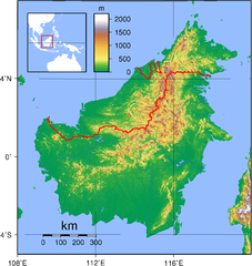
English: Relief (hypsometric) map of Borneo. Red lines represent national borders between Indonesia (south), Malaysia (north), and Brunei (top north). Created with GMT from publicly released GLOBE data[1]. For locator version, see File:Borneo Locator Topography.png.
Français : Carte du relief de l'île de Borneo. Les lignes rouges représentent les frontières séparant les états se partageant l'île de Bornéo : L'Indonésie (au sud), la Malaisie (au nord de l'Indonésie) et l'état de Bruneï (au nord de la Malaisie). Image produite à l'aide de la suite logicielle GMT à partir des données publiques GLOBE. Une version locator est disponible. |
| ရက်စွဲ | |
| ရင်းမြစ် | ကိုယ်ပိုင်ဖန်တီးမှု |
| စာရေးသူ | Sadalmelik |

|
This image has been assessed under the valued image criteria and is considered the most valued image on Commons within the scope: Hypsometric map of Borneo. You can see its nomination here. |
လိုင်စင်သတ်မှတ်ခြင်း
| I, the copyright holder of this work, release this work into the public domain. This applies worldwide. In some countries this may not be legally possible; if so: အကျွန်ုပ်သည် ဤဖန်တီးမှုလက်ရာကို ဥပဒေအရလိုအပ်ခြင်းမရှိသည့် မည်သည့်အခြေအနေမျိုးတွက်မဆို၊ မည်သို့သော ရည်ရွယ်ချက်အတွက်မဆို ၎င်းကို မည်သူမဆို အသုံးပြုပိုင်ခွင့်အား ပေးအပ်သည်။ |
ဖိုင်မှတ်တမ်း
ဖိုင်ကို ယင်းနေ့စွဲ အတိုင်း မြင်နိုင်ရန် နေ့စွဲ/အချိန် တစ်ခုခုပေါ်တွင် ကလစ်နှိပ်ပါ။
| နေ့စွဲ/အချိန် | နမူနာပုံငယ် | မှတ်တမ်း ဒိုင်မန်းရှင်းများ | အသုံးပြုသူ | မှတ်ချက် | |
|---|---|---|---|---|---|
| ကာလပေါ် | ၁၉:၁၇၊ ၁ စက်တင်ဘာ ၂၀၀၇ | | ၁၇၂၅ × ၁၈၂၄ (၂.၅၂ MB) | Sadalmelik | Better data, better colours |
| ၂၀:၅၄၊ ၃ ဇွန် ၂၀၀၇ |  | ၂၀၈၃ × ၂၁၅၈ (၁.၆၇ MB) | Sadalmelik | {{Information |Description=Topographical map of Borneo. Created with GMT from publicly released GLOBE data[http://www.ngdc.noaa.gov/mgg/topo/globe.html]. |Source=self-made |Date=June 3, 2007 |Author= User:Sadalmelik }} Category:Maps of Malaysia |
ဖိုင်သုံးစွဲမှု
အောက်ပါ စာမျက်နှာ သည် ဤဖိုင်ကို အသုံးပြုထားသည်:
ဂလိုဘယ် ဖိုင်သုံးစွဲမှု
အောက်ပါ အခြားဝီကီများတွင် ဤဖိုင်ကို အသုံးပြုထားသည်-
- af.wikipedia.org တွင် အသုံးပြုမှု
- ar.wikipedia.org တွင် အသုံးပြုမှု
- az.wikipedia.org တွင် အသုံးပြုမှု
- ban.wikipedia.org တွင် အသုံးပြုမှု
- be-tarask.wikipedia.org တွင် အသုံးပြုမှု
- be.wikipedia.org တွင် အသုံးပြုမှု
- bg.wikipedia.org တွင် အသုံးပြုမှု
- bn.wikipedia.org တွင် အသုံးပြုမှု
- ca.wikipedia.org တွင် အသုံးပြုမှု
- ceb.wikipedia.org တွင် အသုံးပြုမှု
- de.wikipedia.org တွင် အသုံးပြုမှု
- de.wikivoyage.org တွင် အသုံးပြုမှု
- de.wiktionary.org တွင် အသုံးပြုမှု
- el.wikipedia.org တွင် အသုံးပြုမှု
- el.wiktionary.org တွင် အသုံးပြုမှု
- en.wikipedia.org တွင် အသုံးပြုမှု
- Borneo
- East Malaysia
- Talk:Borneo
- List of endemic birds of Borneo
- Outline of Malaysia
- User:Chickstarr404/Gather lists/13386 – "A Travelers Alphabet" by Stephen Runciman
- Wikipedia:Today's featured list/June 2021
- Wikipedia:Today's featured list/June 11, 2021
- Wikipedia:Main Page history/2021 June 11
- Wikipedia:Main Page history/2021 June 11b
- Phalaenopsis kapuasensis
- Phalaenopsis luteola
- Phalaenopsis modesta
- Phalaenopsis pantherina
- Phalaenopsis × singuliflora
- User:AryKun/Misc
- Naval Base Borneo
- User:Asang Lawai
- Template:User Dayak
- en.wikibooks.org တွင် အသုံးပြုမှု
- en.wikinews.org တွင် အသုံးပြုမှု
- eo.wikipedia.org တွင် အသုံးပြုမှု
- es.wikipedia.org တွင် အသုံးပြုမှု
- et.wikipedia.org တွင် အသုံးပြုမှု
- eu.wikipedia.org တွင် အသုံးပြုမှု
- fa.wikipedia.org တွင် အသုံးပြုမှု
- fi.wikipedia.org တွင် အသုံးပြုမှု
- fo.wikipedia.org တွင် အသုံးပြုမှု
- frr.wikipedia.org တွင် အသုံးပြုမှု
- fr.wikipedia.org တွင် အသုံးပြုမှု
ဤဖိုင်ကို အခြားနေရာများတွင် အသုံးပြုထားမှုများအား ကြည့်ရှုရန်။