
ဖိုင်:Adriatic Sea map.png
ဤနမူနာ၏ အရွယ်အစား - ၄၂၂ × ၅၉၉ ပစ်ဇယ်။ အခြား ပုံရိပ်ပြတ်သားမှု: ၁၆၉ × ၂၄၀ ပစ်ဇယ် | ၃၃၈ × ၄၈၀ ပစ်ဇယ် | ၇၀၄ × ၉၉၉ ပစ်ဇယ်။
မူရင်းဖိုင် (၇၀၄ × ၉၉၉ pixels, ဖိုင်အရွယ်အစား - ၂၃၅ KB, MIME အမျိုးအစား image/png)
| ဤဖိုင်သည် Wikimedia Commons မှဖြစ်ပြီး အခြားပရောဂျက်များတွင် သုံးကောင်းသုံးလိမ့်မည်။ ယင်း၏ ဖိုင်အကြောင်းစာမျက်နှာ တွင် ဖော်ပြထားချက်ကို အောက်တွင် ပြထားသည်။ Commons သည် မူပိုင်ခွင့်လွတ်လပ်သော မီဒီယာဖိုင်များ သိုလှောင်ထားရာ နေရာ ဖြစ်သည်။ သင်လည်း ပါဝင်ကူညီနိုင်ပါသည်။ |

|
This locator map image could be re-created using vector graphics as an SVG file. This has several advantages; see Commons:Media for cleanup for more information. If an SVG form of this image is available, please upload it and afterwards replace this template with
{{vector version available|new image name}}.
It is recommended to name the SVG file “Adriatic Sea map.svg”—then the template Vector version available (or Vva) does not need the new image name parameter. |
အကျဉ်းချုပ်
| ဖော်ပြချက် |
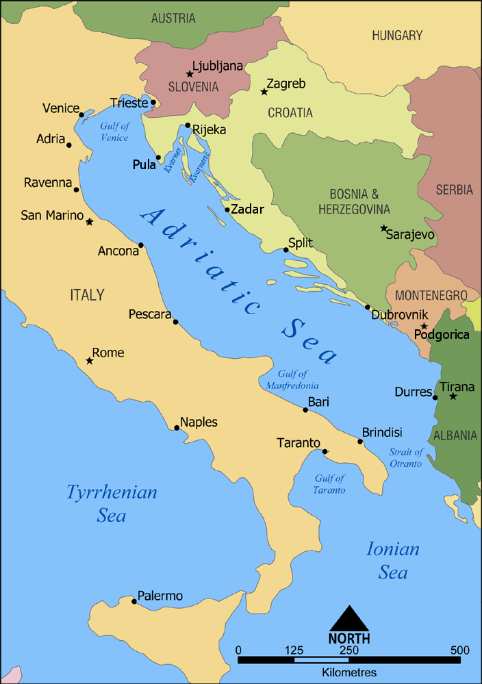
English: A map showing the location of the Adriatic Sea. |
| ရက်စွဲ | |
| ရင်းမြစ် | ကိုယ်ပိုင်ဖန်တီးမှု |
| စာရေးသူ | NormanEinstein |
| အခြား ဗားရှင်းများ |
|


လိုင်စင်သတ်မှတ်ခြင်း
ကျွန်ုပ်၊ ဤလုပ်ဆောင်ချက်၏ မူပိုင်ခွင့်ပိုင်ရှင်အနေဖြင့် ဤနေရာမှ အောက်ပါလိုင်စင်များအောက်တွင် ထုတ်လွှင့်ပါသည်:

|
ဤစာတမ်းကို GNU Free Documentation License, ဗားရှင်း ၁.၂ သို့မဟုတ် Free Software Foundation မှ ဖြန့်ချီထားသော မည်သည့်ယခင်ဗားရှင်းတစ်ခုခုအောက်တွင် Invariant Sections, Front-Cover Texts နှင့် Back-Cover Texts များမပါဝင်ဘဲ ကူးယူခြင်း၊ ဖြန့်ချီခြင်း နှင့်/သို့မဟုတ် ပြင်ဆင်ပြောင်းလဲနိုင်ရန် ခွင့်ပြုသည်။ လိုင်စင်မူပွားကို GNU Free Documentation License ခေါင်းစဉ်အောက်တွင် ထည့်သွင်းထားသည်။ |
| ဤဖိုင်ကို Creative Commons Attribution-Share Alike 3.0 Unported လိုင်စင်ဖြင့် သတ်မှတ်ထားသည်။ | ||
| ||
| This licensing tag was added to this file as part of the GFDL licensing update. |
သင်အလိုရှိရာ လိုင်စင်ကို ရွေးချယ်နိုင်ပါသည်။
ဖိုင်မှတ်တမ်း
ဖိုင်ကို ယင်းနေ့စွဲ အတိုင်း မြင်နိုင်ရန် နေ့စွဲ/အချိန် တစ်ခုခုပေါ်တွင် ကလစ်နှိပ်ပါ။
| နေ့စွဲ/အချိန် | နမူနာပုံငယ် | မှတ်တမ်း ဒိုင်မန်းရှင်းများ | အသုံးပြုသူ | မှတ်ချက် | |
|---|---|---|---|---|---|
| ကာလပေါ် | ၁၆:၀၀၊ ၂၃ ဖေဖော်ဝါရီ ၂၀၂၃ | | ၇၀၄ × ၉၉၉ (၂၃၅ KB) | Doremo | slightly trimmed, marked 2008 border change |
| ၀၉:၁၅၊ ၉ ဖေဖော်ဝါရီ ၂၀၁၂ |  | ၇၃၅ × ၁၀၀၀ (၂၃၉ KB) | Joy | Added Pula, Zadar, Podgorica | |
| ၁၉:၂၀၊ ၁၈ ဇန်နဝါရီ ၂၀၁၀ |  | ၇၃၅ × ၁၀၀၀ (၃၀၂ KB) | Buttons~commonswiki | Reverted to version as of 02:46, 10 July 2006 Kosovo is not recognized by the UN or EU | |
| ၁၈:၅၇၊ ၁၀ စက်တင်ဘာ ၂၀၀၈ |  | ၇၃၅ × ၁၀၀၀ (၂၅၆ KB) | Admiral Norton | Reverted to Kosovo version, it's independent now | |
| ၀၂:၄၆၊ ၁၀ ဇူလိုင် ၂၀၀၆ |  | ၇၃၅ × ၁၀၀၀ (၃၀၂ KB) | NormanEinstein | Reverting to March 2 2006 version; didn't realize Hipi Zhdripi's edits included showing Kosovo as a separate country. | |
| ၁၆:၄၁၊ ၉ ဇူလိုင် ၂၀၀၆ |  | ၇၃၅ × ၁၀၀၀ (၂၅၆ KB) | NormanEinstein | Reverting to last version by Hipi Zhdripi. Philjon, if you want to change the colours and text, that's fine, but upload it as a new image. | |
| ၁၇:၄၀၊ ၂၅ ဇွန် ၂၀၀၆ |  | ၄၄၁ × ၆၀၀ (၃၃ KB) | Philjon~commonswiki | ||
| ၁၇:၃၉၊ ၂၅ ဇွန် ၂၀၀၆ |  | ၄၄၁ × ၆၀၀ (၃၃ KB) | Philjon~commonswiki | Ameloliored version of this map | |
| ၂၂:၂၇၊ ၂၄ ဇွန် ၂၀၀၆ |  | ၄၄၁ × ၆၀၀ (၃၄ KB) | Philjon~commonswiki | Image améliorée par ~~~ {{Atelier graphique carte}} | |
| ၀၅:၁၇၊ ၂ ဧပြီ ၂၀၀၆ |  | ၇၃၅ × ၁၀၀၀ (၂၅၆ KB) | Hipi Zhdripi~commonswiki |
ဖိုင်သုံးစွဲမှု
အောက်ပါ စာမျက်နှာ သည် ဤဖိုင်ကို အသုံးပြုထားသည်:
ဂလိုဘယ် ဖိုင်သုံးစွဲမှု
အောက်ပါ အခြားဝီကီများတွင် ဤဖိုင်ကို အသုံးပြုထားသည်-
- af.wikipedia.org တွင် အသုံးပြုမှု
- als.wikipedia.org တွင် အသုံးပြုမှု
- am.wikipedia.org တွင် အသုံးပြုမှု
- an.wikipedia.org တွင် အသုံးပြုမှု
- azb.wikipedia.org တွင် အသုံးပြုမှု
- az.wiktionary.org တွင် အသုံးပြုမှု
- ban.wikipedia.org တွင် အသုံးပြုမှု
- ba.wikipedia.org တွင် အသုံးပြုမှု
- be-tarask.wikipedia.org တွင် အသုံးပြုမှု
- be.wikipedia.org တွင် အသုံးပြုမှု
- bh.wikipedia.org တွင် အသုံးပြုမှု
- bn.wikipedia.org တွင် အသုံးပြုမှု
- bs.wikipedia.org တွင် အသုံးပြုမှု
- cdo.wikipedia.org တွင် အသုံးပြုမှု
- ce.wikipedia.org တွင် အသုံးပြုမှု
- ckb.wikipedia.org တွင် အသုံးပြုမှု
- da.wikipedia.org တွင် အသုံးပြုမှု
- de.wikipedia.org တွင် အသုံးပြုမှု
- diq.wikipedia.org တွင် အသုံးပြုမှု
- el.wikipedia.org တွင် အသုံးပြုမှု
- el.wiktionary.org တွင် အသုံးပြုမှု
- eml.wikipedia.org တွင် အသုံးပြုမှု
- en.wikipedia.org တွင် အသုံးပြုမှု
- Croatian Navy
- Austro-Hungarian Navy
- User:NormanEinstein/gallery
- Wikipedia:Graphics Lab/Images to improve/Archive/Apr 2008
- Adriatic Sea
- Gulf of Manfredonia
- Battle of Durazzo (1918)
- 1918–1920 unrest in Split
- User:Chickstarr404/Gather lists/12385 – "The Eastern Shores of the Adriatic in 1863" by Emily Anne Beaufort
- User:Chickstarr404/Gather lists
- Fauna of Montenegro
- es.wikipedia.org တွင် အသုံးပြုမှု
- fa.wikipedia.org တွင် အသုံးပြုမှု
- fi.wikipedia.org တွင် အသုံးပြုမှု
- frp.wikipedia.org တွင် အသုံးပြုမှု
- frr.wikipedia.org တွင် အသုံးပြုမှု
- fr.wikipedia.org တွင် အသုံးပြုမှု
- gag.wikipedia.org တွင် အသုံးပြုမှု
- hak.wikipedia.org တွင် အသုံးပြုမှု
- id.wikipedia.org တွင် အသုံးပြုမှု
- ilo.wikipedia.org တွင် အသုံးပြုမှု
ဤဖိုင်ကို အခြားနေရာများတွင် အသုံးပြုထားမှုများအား ကြည့်ရှုရန်။