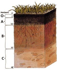
ဖိုင်:Soil profile.jpg
Soil_profile.jpg (၂၃၆ × ၂၈၈ pixels, ဖိုင်အရွယ်အစား - ၃၉ KB, MIME အမျိုးအစား image/jpeg)
ဖိုင်မှတ်တမ်း
ဖိုင်ကို ယင်းနေ့စွဲ အတိုင်း မြင်နိုင်ရန် နေ့စွဲ/အချိန် တစ်ခုခုပေါ်တွင် ကလစ်နှိပ်ပါ။
| နေ့စွဲ/အချိန် | နမူနာပုံငယ် | မှတ်တမ်း ဒိုင်မန်းရှင်းများ | အသုံးပြုသူ | မှတ်ချက် | |
|---|---|---|---|---|---|
| ကာလပေါ် | ၀၀:၃၅၊ ၂၄ နိုဝင်ဘာ ၂၀၀၄ |  | ၂၃၆ × ၂၈၈ (၃၉ KB) | Paleorthid | Soil profile 236x288 38.76 KB {{PD-USGov-USDA}} |
ဖိုင်သုံးစွဲမှု
ဤဖိုင်ကို အသုံးပြုထားသော စာမျက်နှာများမရှိပါ။
ဂလိုဘယ် ဖိုင်သုံးစွဲမှု
အောက်ပါ အခြားဝီကီများတွင် ဤဖိုင်ကို အသုံးပြုထားသည်-
- af.wikipedia.org တွင် အသုံးပြုမှု
- ar.wikipedia.org တွင် အသုံးပြုမှု
- ast.wikipedia.org တွင် အသုံးပြုမှု
- as.wikipedia.org တွင် အသုံးပြုမှု
- az.wikipedia.org တွင် အသုံးပြုမှု
- be-tarask.wikipedia.org တွင် အသုံးပြုမှု
- be.wikipedia.org တွင် အသုံးပြုမှု
- bh.wikipedia.org တွင် အသုံးပြုမှု
- bjn.wikipedia.org တွင် အသုံးပြုမှု
- bn.wikipedia.org တွင် အသုံးပြုမှု
- ca.wikipedia.org တွင် အသုံးပြုမှု
- cs.wikipedia.org တွင် အသုံးပြုမှု
- cy.wikipedia.org တွင် အသုံးပြုမှု
- da.wikipedia.org တွင် အသုံးပြုမှု
- de.wikipedia.org တွင် အသုံးပြုမှု
- Podsol
- Boden (Bodenkunde)
- Solonetz
- USDA Soil Taxonomy
- Inceptisol
- Entisol
- Andisol
- Gelisol
- Alfisol
- Oxisol
- Histosol
- Spodosol
- Ultisol
- Aridisol
- Vertisol
- Mollisol
- Portal:Geowissenschaften
- Portal:Geowissenschaften/Disziplinen
- Benutzer:BK-Thorsten/Entwurf
- Benutzer:BK-Thorsten
- Acrisol
- Ferralsol
- Nitisol
- Cryosol
- Benutzer:Flaovia/Humus
ဤဖိုင်ကို အခြားနေရာများတွင် အသုံးပြုထားမှုများအား ကြည့်ရှုရန်။


